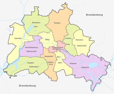
Boroughs and neighborhoods of Berlin

Last updated
The districts and neighbourhoods of Berlin Berlin, administrative divisions (+districts +boroughs -pop) - de - colored.svg
The districts and neighbourhoods of Berlin
The 12 Berlin Bezirke (districts) - following the 2001 district reform The 12 Berlin Bezirke.jpg
The 12 Berlin Bezirke (districts) - following the 2001 district reform

Berlin is both a city and one of Germany's federated states (city state). Since the 2001 administrative reform, it has been made up of twelve districts (German : Bezirke, pronounced [bəˈtsɪʁkə] ), each with its own administrative body. However, unlike the municipalities and counties of other German states, the Berlin districts are not territorial corporations of public law (Gebietskörperschaften) with autonomous competencies and property, but simple administrative agencies of Berlin's state and city government, the City of Berlin forming a single municipality (Einheitsgemeinde) since the Greater Berlin Act of 1920. Thus they cannot be equated to US or UK boroughs in the traditional meaning of the term.

Contents

Each district possesses a district representatives' assembly (Bezirksverordnetenversammlung) directly elected by proportional representation and an administrative body called district board (Bezirksamt). The district board, comprising since October 2021 six (until then five) members - a district mayor (Bezirksbürgermeister) as head and five (earlier four) district councillors (Bezirksstadträte) - is elected by the district representatives' assembly, proportionally reflecting its party composition according to popular vote. The district board is in charge of most local administrative matters directly relevant to local citizens; however, all of its decisions can at any moment be revoked by the Berlin Senate. Furthermore, the districts are financially completely dependent on state donations, as they neither possess any taxation power nor own any property. The district mayors form a council of mayors (Rat der Bürgermeister, led by the city's governing mayor), which advises the Senate.

History

Twenty-three former boroughs (1990-2000) Berliner Bezirke vor 2001.png
Twenty-three former boroughs (1990–2000)

Each borough is made up of several officially recognized subdistricts or neighborhoods (Ortsteile in German, sometimes called quarters in English). The number of neighborhoods that form a borough varies considerably, ranging from two (Friedrichshain-Kreuzberg) to fifteen (Treptow-Köpenick). These neighborhoods typically have a historical identity as former independent cities, villages, or rural municipalities that were united in 1920 as part of the Greater Berlin Act, forming the basis for the present-day city and state. The neighborhoods do not have their own governmental bodies but are recognized by the city and the boroughs for planning and statistical purposes. Berliners often identify more with the neighborhood where they live than with the borough that governs them. The neighborhoods are further subdivided into statistical tracts, which are mainly used for planning and statistical purposes. The statistical tracts correspond roughly but not exactly with neighborhoods recognized by residents.

When Greater Berlin was established in 1920, the city was organized into twenty boroughs, most of which were named after their largest component neighborhood, often a former city or municipality; others, such as Kreuzberg and Prenzlauer Berg, were named for geographic features. Minor changes to borough boundaries were made in 1938. After World War II, Berlin was divided into four sectors, with the Western sectors controlled by the United States, Britain, and France, and the Eastern sector controlled by the Soviet Union.

In 1961, the SED built the Berlin Wall to divide the city, effectively separating West Berlin from East Berlin and the rest of East Germany. Three new boroughs were created in East Berlin: Marzahn was split off from Lichtenberg in 1979, Hohenschönhausen from Weissensee in 1985, and Hellersdorf from Marzahn in 1986. In 1989, the Berlin Wall fell, and the city was reunified. This marked the end of the Cold War and the beginning of a new era in Berlin's history.

After reunification, Berlin underwent a process of rapid transformation, as the city worked to rebuild and modernize its infrastructure and economy. Many new businesses and cultural institutions were established, and the city became a center of creativity and innovation.

By 2000, Berlin comprised twenty-three boroughs, as three new boroughs had been created in East Berlin. Today Berlin is divided into twelve boroughs (Bezirke), reduced from twenty-three boroughs before Berlin's 2001 administrative reform.

Boroughs

An administrative reform in 2001 merged all but three of the existing boroughs into the current 12 boroughs, as listed below. [1] The three boroughs that were not affected were Spandau, Reinickendorf and Neukölln, as the population of each was already exceeding 200,000.

Borough Bundestag constituency Population
31 December 2023
Area
in km2
Density
per km2
Map
Charlottenburg-Wilmersdorf Berlin-Charlottenburg-Wilmersdorf
(excluding Charlottenburg-Nord and the neighbourhood of Kalowswerder)
343,08164.725,301 Berlin, administrative divisions (+districts -boroughs -pop) - de - colored.svg
Friedrichshain-Kreuzberg Berlin-Friedrichshain-Kreuzberg – Prenzlauer Berg East 293,45420.1614,556
Lichtenberg Berlin-Lichtenberg 311,88152.295,964
Marzahn-Hellersdorf Berlin-Marzahn-Hellersdorf 291,94861.744,728
Mitte Berlin-Mitte 397,13439.4710,062
Neukölln Berlin-Neukölln 330,01744.937,345
Pankow Berlin-Pankow
(excluding Prenzlauer Berg east of Prenzlauer Allee)
424,307103.014,119
Reinickendorf Berlin-Reinickendorf 268,79289.463,005
Spandau Berlin-Spandau – Charlottenburg North 257,09191.912,797
Steglitz-Zehlendorf Berlin-Steglitz-Zehlendorf 310,446102.503,029
Tempelhof-Schöneberg Berlin-Tempelhof-Schöneberg 355,86853.096,703
Treptow-Köpenick Berlin-Treptow-Köpenick 294,081168.421,746

Administration

The borough government is part of the two-tier administration of the Berlin city-state, whereby the Senate and its affiliated agencies, institutions, and municipal enterprises form the first tier of the so-called Hauptverwaltung (central administration). In the second tier, the boroughs enjoy a certain grade of autonomy—though in no way comparable to the German Landkreise districts or independent cities, nor even to the local government of a common municipality as a legal entity, as according to the Berlin Constitution the legal status of the city as a German state itself is that of a unified municipality (Einheitsgemeinde). The power of the borough governments is limited and their performance of assigned tasks is subject to regulatory supervision by the Senate.

Nevertheless, the twelve self-governing boroughs have constitutional status and are themselves subdivided into two administrative bodies: each is governed by the borough assembly (Bezirksverordnetenversammlung, BVV) and a full-time borough council (Bezirksamt), consisting of five councilors (Bezirksstadträte) and headed by a borough mayor (Bezirksbürgermeister). The BVV assembly is directly elected by the borough's population and therefore acts as a borough parliament, though it is officially part of the executive. It elects the members of the borough council, checks its daily administration, and is able to make applications and recommendations. The twelve borough mayors regularly meet in the Council of Mayors (Rat der Bürgermeister), led by the city's Governing Mayor; the council answers to and advises the Senate.

The localities have no local government bodies, and the administrative duties of the former locality representative, the Ortsvorsteher, were taken over by the borough mayors.

Coats of arms

The mural crown of the coats of arms of Berliner Bezirke Mural crown of the coat of arms of the Berlin boroughs.svg
The mural crown of the coats of arms of Berliner Bezirke

All the coats of arms of Berliner boroughs (the current as of the ones in the period 1990 to 2001) have some common points: The shield has a Spanish form and the coronet is represented by a mural crown: 3 towers in red bricks with the coat of arms of Berlin in the middle.

Most of the coats of arms of current boroughs [2] have changed some elements in their field: Some of them have created a "fusion" of themes of the merged Bezirke (Charlottenburg-Wilmersdorf, Lichtenberg, Steglitz-Zehlendorf, Tempelhof-Schöneberg); others have modified their themes taken from one of the two (or more) former merged boroughs (Friedrichshain-Kreuzberg, Marzahn-Hellersdorf, Mitte and Treptow-Köpenick). Only the unchanged boroughs of Neukölln, Reinickendorf and Spandau have not changed their field. The coat of arms of Pankow was created with a new design in 2008, having been the only district without an emblem for 7 years.

Coat of arms of Charlottenburg-Wilmersdorf.svg
Charlottenburg-Wilmersdorf
Coat of arms of borough Friedrichshain-Kreuzberg.svg
Friedrichshain-Kreuzberg
Coat of arms of borough Lichtenberg.svg
Lichtenberg
Coat of arms of borough Marzahn-Hellersdorf.svg
Marzahn-Hellersdorf
Coat of arms of borough Mitte.svg
Mitte
Coat of arms of borough Neukoelln.svg
Neukölln
Coat of arms of borough Pankow.svg
Pankow
Coat of arms of borough Reinickendorf.svg
Reinickendorf
Coat of arms of borough Spandau.svg
Spandau
Coat of arms of borough Steglitz-Zehlendorf.svg
Steglitz-Zehlendorf
Coat of arms of borough Tempelhof-Schoeneberg.svg
Tempelhof-Schöneberg
Coat of arms of borough Treptow-Koepenick.svg
Treptow-Köpenick

Localities

As of 2012, the twelve boroughs are made up of a total of 97 officially recognized localities (Ortsteile). Almost all of them are further subdivided into several other zones (defined in German as Ortslagen, Teile, Stadtviertel, Orte etc.). The largest Ortsteil is Köpenick (34.9 km2 or 13.5 sq mi), the smallest one is Hansaviertel (53 ha or 130 acres). The most populated is Neukölln (154,127 inhabitants in 2009), the least populated is Malchow (450 inhabitants in 2008). [3]

The coats of arms of the Localitys lost their validity with the incorporation into Greater Berlin/in new districts and thus disappeared from official use. The coats of arms listed here are the historically used signs.

(01) Mitte
LocalityArea
in km2
Population
as of 2008
Density
inhabitants per km2
Map
DEU Berlin-Mitte (district) COA.svg (0101) Mitte 10.7079,5827,445 Berlin Mitte.svg
Sin escudo.svg (0102) Moabit 7.7269,4258,993
Sin escudo.svg (0103) Hansaviertel 0.535,88911,111
Coat of arms de-be tiergarten 1955.png (0104) Tiergarten 5.1712,4862,415
DEU Wedding COA.svg (0105) Wedding 9.2376,3638,273
Sin escudo.svg (0106) Gesundbrunnen                 6.1382,72913,496
(02) Friedrichshain-Kreuzberg
LocalityArea
in km2
Population
as of 2008
Density
inhabitants per km2
Map
Coat of arms de-be friedrichshain 1991.png (0201) Friedrichshain                  9.78114,05011,662 Berlin Friedrichshain-Kreuzberg.svg
DEU Kreuzberg (district) COA.svg (0202) Kreuzberg 10.40147,22714,184
(03) Pankow
LocalityArea
in km2
Population
as of 2008
Density
inhabitants per km2
Map
DEU Prenzlauer Berg (Bezirk) COA.svg (0301) Prenzlauer Berg 11.00142,31912,991 Berlin Pankow.svg
DEU Weissensee (district) COA.svg (0302) Weißensee 7.9345,4855,736
Sin escudo.svg (0303) Blankenburg 6.036,5501,086
Sin escudo.svg (0304) Heinersdorf 3.956,5801,666
Sin escudo.svg (0305) Karow 6.6518,2582,746
Sin escudo.svg (0306) Stadtrandsiedlung Malchow       5.681,166205
Coat of arms de-be pankow 1987.png (0307) Pankow 5.6655,8549,868
Sin escudo.svg (0308) Blankenfelde 13.401,917144
Coat of arms de-be buch 1987.png (0309) Buch 18.2013,188727
Coat of arms de-be buchholz 1987.png (0310) Französisch Buchholz 12.0018,7661,560
Coat of arms de-be niederschoenhausen 1987.png (0311) Niederschönhausen 6.4926,9034,145
Coat of arms de-be rosenthal 1987.png (0312) Rosenthal 4.908,9331,823
Sin escudo.svg (0313) Wilhelmsruh 1.377,2165,267
(04) Charlottenburg-Wilmersdorf
LocalityArea
in km2
Population
as of 2008
Density
inhabitants per km2
Map
DEU Charlottenburg (district) COA.svg (0401) Charlottenburg 10.60118,70411,198 Berlin Charlottenburg-Wilmersdorf.svg
DEU Wilmersdorf (district) COA.svg (0402) Wilmersdorf 7.1692,81512,963
Coats of arms of None.svg (0403) Schmargendorf 3.5919,7505,501
Coats of arms of None.svg (0404) Grunewald 22.3010,014448
Coats of arms of None.svg (0405) Westend 13.5037,8832,800
Coats of arms of None.svg (0406) Charlottenburg-Nord             6.2017,3272,795
Coats of arms of None.svg (0407) Halensee 1.2713,96610,997
(05) Spandau
LocalityArea
in km2
Population
as of 2008
Density
inhabitants per km2
Map
Coats of arms of None.svg (0501) Spandau 8.0333,4334,164 Berlin Spandau.svg
Coats of arms of None.svg (0502) Haselhorst 4.7313,6682,891
Coats of arms of None.svg (0503) Siemensstadt 5.6611,3882,012
Coats of arms of None.svg (0504) Staaken 10.9041,4703,810
Coats of arms of None.svg (0505) Gatow 10.103,908386
Coats of arms of None.svg (0506) Kladow 14.8013,628922
Coats of arms of None.svg (0507) Hakenfelde 20.4026,3371,292
Coats of arms of None.svg (0508) Falkenhagener Feld             6.8834,7785,056
Coats of arms of None.svg (0509) Wilhelmstadt 10.4037,0803,558
(06) Steglitz-Zehlendorf
LocalityArea
in km2
Population
as of 2008
Density
inhabitants per km2
Map
DEU District Steglitz COA.svg (0601) Steglitz 6.7970,55510,391 Berlin Steglitz-Zehlendorf.svg
DEU Berlin-Lichterfelde COA.jpg (0602) Lichterfelde                    18.2078,3384,300
Coa Germany Town Berlin-Lankwitz.svg (0603) Lankwitz 6.9940,3855,778
Coat of arms de-be zehlendorf 1956.png (0604) Zehlendorf 18.8057,9023,075
Coats of arms of None.svg (0605) Dahlem 8.3614,9661,784
Coats of arms of None.svg (0606) Nikolassee 19.6115,899811
Coats of arms of None.svg (0607) Wannsee 23.689,044382
Coats of arms of None.svg (0608) Schlachtensee 4.0510,5732,611
(07) Tempelhof-Schöneberg
LocalityArea
in km2
Population
as of 2008
Density
inhabitants per km2
Map
Coat of arms de-be schoeneberg 1956.png (0701) Schöneberg                    10.60116,74311,003 Berlin Tempelhof-Schoneberg.svg
Coats of arms of None.svg (0702) Friedenau 1.6526,73616,204
DEU District Tempelhof COA.svg (0703) Tempelhof 12.2054,3824,458
Coats of arms of None.svg (0704) Mariendorf 9.3848,8825,211
Coats of arms of None.svg (0705) Marienfelde 9.1530,1513,295
Coats of arms of None.svg (0706) Lichtenrade 10.1049,4514,896
(08) Neukölln
LocalityArea
in km2
Population
as of 2008
Density
inhabitants per km2
Map
Coats of arms of None.svg (0801) Neukölln 11.70154,12713,173 Berlin Neukolln.svg
Coats of arms of None.svg (0802) Britz 12.4038,3343,091
Coats of arms of None.svg (0803) Buckow 6.3538,0185,987
Coats of arms of None.svg (0804) Rudow 11.8041,0403,478
Coats of arms of None.svg (0805) Gropiusstadt                    2.6635,84413,475
(09) Treptow-Köpenick
LocalityArea
in km2
Population
as of 2008
Density
inhabitants per km2
Map
Coat of arms de-be treptow 1992.png (0901) Alt-Treptow 2.3110,4264,513 Berlin Treptow-Kopenick.svg
Coats of arms of None.svg (0902) Plänterwald 3.0110,6183,528
Coats of arms of None.svg (0903) Baumschulenweg 4.8216,7803,481
Coat of arms de-be johannisthal 1987.png (0904) Johannisthal 6.5417,6502,699
Coats of arms of None.svg (0905) Niederschöneweide              3.4910,0432,878
Coats of arms of None.svg (0906) Altglienicke 7.8926,1013,308
Coats of arms of None.svg (0907) Adlershof 6.1115,1122,473
Coats of arms of None.svg (0908) Bohnsdorf 6.5210,7511,649
Coat of arms de-be oberschoeneweide 1987.png (0909) Oberschöneweide 6.1817,0942,766
DEU Kopenick (district) COA.svg (0910) Köpenick 34.9059,2011,695
Coat of arms de-be friedrichshagen 1987.png (0911) Friedrichshagen 14.0017,2851,233
Coat of arms de-be rahnsdorf 1987.png (0912) Rahnsdorf 21.508,891414
Coats of arms of None.svg (0913) Grünau 9.135,482600
Wappen Muggelheim (Berlin).png (0914) Müggelheim 22.206,350286
Coat of arms de-be schmoeckwitz 1987.png (0915) Schmöckwitz 17.104,117240
(10) Marzahn-Hellersdorf
LocalityArea
in km2
Population
as of 2008
Density
inhabitants per km2
Map
Coat of arms de-be marzahn 1992.png (1001) Marzahn 19.50102,3985,240 Berlin Marzahn-Hellersdorf.svg
Coats of arms of None.svg (1002) Biesdorf 12.4024,5431,973
Coats of arms of None.svg (1003) Kaulsdorf 8.8118,7322,126
Coat of arms de-be mahlsdorf 1987.png (1004) Mahlsdorf 12.9026,8522,075
Coat of arms de-be hellersdorf 1992.png (1005) Hellersdorf                     8.1072,6028,963
(11) Lichtenberg
LocalityArea
in km2
Population
as of 2008
Density
inhabitants per km2
Map
Coat of arms de-be friedrichsfelde 1987.png (1101) Friedrichsfelde 5.5550,0109,011 Berlin Lichtenberg.svg
Coats of arms of None.svg (1102) Karlshorst 6.6021,3293,232
Coat of arms de-be lichtenberg 1987.png (1103) Lichtenberg 7.2232,2954,473
Coats of arms of None.svg (1104) Falkenberg 3.061,164380
Coats of arms of None.svg (1106) Malchow 1.54450292
Coats of arms of None.svg (1107) Wartenberg 6.922,433352
Coats of arms of None.svg (1109) Neu-Hohenschönhausen          5.1653,69810,407
Coat of arms de-be hohenschoenhausen.png (1110) Alt-Hohenschönhausen 9.3341,7804,478
Coats of arms of None.svg (1111) Fennpfuhl 2.1230,93214,591
Coats of arms of None.svg (1112) Rummelsburg 4.5217,5673,887
(12) Reinickendorf
LocalityArea
in km2
Population
as of 2008
Density
inhabitants per km2
Map
Coats of arms of None.svg (1201) Reinickendorf 10.5072,8596,939 Berlin Reinickendorf.svg
Coats of arms of None.svg (1202) Tegel 33.7033,417992
Coats of arms of None.svg (1203) Konradshöhe 2.205,9972,726
Coats of arms of None.svg (1204) Heiligensee 10.7017,6411,649
Wappen-frohnau.jpg (1205) Frohnau 7.8017,0252,183
WappenvoHermsdorf.jpg (1206) Hermsdorf 6.1016,5032,705
Coats of arms of None.svg (1207) Waidmannslust 2.3010,0224,357
Coats of arms of None.svg (1208) Lübars 5.004,915983
Coat of arms de-be wittenau 1905.svg (1209) Wittenau 5.8722,6963,866
Coats of arms of None.svg (1210) Märkisches Viertel               3.2035,20611,002
Coat of arms de-be Borsigwalde.jpg (1211) Borsigwalde               2.036,4323,168

See also

Related Research Articles

<span class="mw-page-title-main">Pankow</span> Borough of Berlin in Germany

Pankow is the most populous and the second-largest borough by area of Berlin. In Berlin's 2001 administrative reform, it was merged with the former boroughs of Prenzlauer Berg and Weißensee; the resulting borough retained the name Pankow. Pankow was sometimes claimed by the Western Allies to be the capital of the German Democratic Republic, while the German Democratic Republic itself considered East Berlin to be its capital.

<span class="mw-page-title-main">Marzahn-Hellersdorf</span> Borough of Berlin in Germany

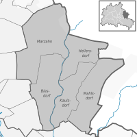
Marzahn-Hellersdorf is the tenth borough of Berlin, formed in 2001 by merging the former boroughs of Marzahn and Hellersdorf.

<span class="mw-page-title-main">Lichtenberg</span> Borough of Berlin in Germany

Lichtenberg is the eleventh borough of Berlin, Germany. In Berlin's 2001 administrative reform it absorbed the former borough of Hohenschönhausen.

<span class="mw-page-title-main">Rummelsburg</span> Quarter of Berlin in Germany

Rummelsburg is a subdivision or neighborhood (Ortsteil) of the borough (Bezirk) of Lichtenberg of the German capital, Berlin.

The Greater Berlin Act, officially Law Regarding the Creation of the New Municipality of Berlin, was a law passed by the Prussian state government in 1920, which greatly expanded the size of the Prussian and German capital of Berlin.

<span class="mw-page-title-main">Flag of Berlin</span> Official flag of the German city state of Berlin

The state flag of Berlin, Germany has three stripes of red-white-red, the two outer stripes each occupying a fifth of its height, the middle the remaining three-fifths. It is emblazoned with a bear on the civil flag, while it bears the coat of arms of Berlin on the state flag.

<span class="mw-page-title-main">Lichtenberg (locality)</span> Quarter of Berlin in Germany

Lichtenberg is a quarter (Ortsteil) of Berlin in the homonymous borough (Bezirk) of Lichtenberg. Until 2001 it was an autonomous district with the localities of Fennpfuhl, Rummelsburg, Friedrichsfelde and Karlshorst.
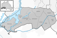
<span class="mw-page-title-main">Neukölln (locality)</span> Quarter of Berlin in Germany

Neukölln, until 1920 an independent city, is a large inner-city quarter (Ortsteil) of Berlin in the homonymous borough (Bezirk) of Neukölln, including the historic village of Alt-Rixdorf and numerous Gründerzeit apartment blocks. With 166,714 inhabitants (2018) the Ortsteil is the most densely populated of Berlin. It was originally characterized by mostly working-class inhabitants and later a relatively high percentage of immigrants, especially of Turkish and Russian descent, but since the turn of the millennium an influx of students, creatives, and western immigrants has led to gentrification.

<span class="mw-page-title-main">Alt-Treptow</span> Quarter of Berlin in Germany

Alt-Treptow is a German locality in the borough of Treptow-Köpenick in Berlin. Known also as Treptow it was, until 2001, the main and the eponymous locality of the former Treptow borough.

<span class="mw-page-title-main">Bus transport in Berlin</span> Overview of the bus transport in Berlin

Bus transport is the oldest public transport service in Berlin, the capital city of Germany, having been introduced in 1846. Since 1929, services have been operated by the Berlin Transport Company, although during the Cold War-era division of the city they operated in West Berlin only. In East Berlin the public transport agency split off from the BVG and rebranded as BVB, operating the busses in the soviet sector of Berlin.

<span class="mw-page-title-main">Ferry transport in Berlin</span> Overview of the ferry transport in Berlin

Ferry transport forms part of the transport network of Berlin due to the city's extensive network of rivers, lakes, and canals. 6 routes operate within the city boundaries and one serves the city of Potsdam, which are part of the common public transport tariff run by the Verkehrsverbund Berlin-Brandenburg (VBB).

<span class="mw-page-title-main">Mahlsdorf</span> Quarter of Berlin in Germany

Mahlsdorf is a locality (Ortsteil) within the Berlin borough (Bezirk) of Marzahn-Hellersdorf. Until 2001 it was part of the former borough of Hellersdorf.

<span class="mw-page-title-main">Biesdorf (Berlin)</span> Quarter of Berlin in Germany

Biesdorf is a locality (Ortsteil) within the Berlin borough (Bezirk) of Marzahn-Hellersdorf. Until 2001 it was part of the former borough of Marzahn.

<span class="mw-page-title-main">Plänterwald</span> Quarter of Berlin in Germany

Plänterwald is a German locality (Ortsteil) within the Berlin borough (Bezirk) of Treptow-Köpenick. Until 2001 it was part of the former borough of Treptow and the site of its former town hall.

<span class="mw-page-title-main">Politics of Berlin</span>

Berlin is a city-state and the capital of the Federal Republic of Germany.

The Berliner Abendblatt is the leading weekly advertising paper in Berlin, Germany alongside the Berliner Woche and, along with Einkaufaktuell, one of the three main media for the collective distribution of the weekly brochures of retail chains in Berlin.

References