This section may be too long to read and navigate comfortably. Consider splitting content into sub-articles, condensing it, or adding subheadings. Please discuss this issue on the article's talk page.(January 2022)
Originally named Dalldorf it was first mentioned in 1332.[2] In 1869 the city of Berlin had acquired land in the Dalldorf in order to build the Städtische Irrenanstalt zu Dalldorf (Municipal Mental Asylum at Dalldorf), today's Karl-Bonhoeffer-Nervenklinik (Karl Bonhoeffer mental home), between 1877 and 1879.[3] In the following years Dalldorf became the synonym for 'madhouse' in Berlin parlance.[4] Therefore, in 1903 Dalldorf applied at the Niederbarnim district commissioner for a new toponym, Wittenau after its late mayor Peter Witte, granted by the Prussian government with effect of 23 August 1905.[5] In 1920 Wittenau merged into Berlin by the Greater Berlin Act.
After the capture of the district by the Red Army was relatively quickly formed again a provisional local government. This was because small groups of anti-fascists found themselves ready to take over the administration in coordination with the occupiers. In Wittenau Anton Jadasch was appointed mayor. Immediately after the end of the fighting in Berlin, the Soviet occupying power began with the dismantling of undamaged industrial plants and their facilities. The temporary British occupying power did not continue this. However, with the arrival of the French Allies as final occupying power, the dismantling began again. These continue until the signing of the Petersberg Agreement on 22 November 1949. Nevertheless, some companies were able to produce different products again as early as November 1945, the former armaments factories in Wittenau mainly produced household goods and products needed for reconstruction (the Mauserwerke, for example, potato hoes and bread loaves, the former German weapons and munitions factories now made ovens and building hardware ago). However, the industry in Wittenau, which had just regained momentum, was suddenly slowed down by the Berlin blockade in the years 1948/1949. Numerous companies temporarily stopped production, especially craft enterprises only resumed work several months after the blockade ended. The political reconstruction progressed faster: already in September 1950, the foundation stone was laid for the cultivation at the town hall Reinickendorf. Only for the period after 1953 is a noticeable growth of industrial production demonstrable. Many companies were able to expand their production at this time (e.g. Waggon Union, ZF Friedrichshafen), others were just in this time in the district (e.g. Collonil). Not only industrial enterprises settled in Wittenau, also the largest of the residential complexes for the members of the French armed forces – the Cité Foch – originated here since 1953. Several blocks of flats along the Cyclopstraße later followed numerous residential, administrative and supply buildings northeast of the demolished today Wittenau freight yard on the border with Waidmannslust. The location on the edge of the district and the fact that the French representatives resided in Waidmannslust (see: Former residence of the High Commissioner of the French Republic for Germany), still today lead to the fact that the Cité Foch is falsely counted among Waidmannslust. Even the Federal Real Estate Agency, which manages the area today, makes that mistake.
The construction of the Berlin Wall in 1961 also had far-reaching consequences for the Wittenau economy. As in the entire district of Reinickendorf, the number of small businesses declined and work was increasingly carried out in companies with more than ten employees. Furthermore, the public administration with the construction of the tax office Reinickendorf in 1976 once again centralized. This constellation required – as well as the low cultural offer – an efficient infrastructure. As early as 1958, the then subway line C (today: Line U6) had been extended to Tegel, whereby at least Borsigwalde was affected by the subway. As part of the S-Bahn boycott in West Berlin Wittenau was increasingly dependent on the Berlin subway, buses and private transport. The complete suspension of train operations on the Kremmener Bahn and the Nordbahn in January 1984 exacerbated this situation even further. The eastern part of Wittenau already had a well developed north-south connection for private transport with the federal highway 96. In addition, in the 1970s with the construction of the A 111 – a feeder for the Berlin city highway and the Berlin Ring – began, the complete completion lasted until 1987. With the junction Holzhauser road West Wittenau was a direct connection to the city center. In the 1970s and 1980s not only Wittenau was invested in the transport infrastructure, but also in public buildings: In 1971, the construction of the Ringelnatz elementary school in Wilhelm-Gericke-Straße was completed, followed only a year later, the Peter Witte primary school in the town hall promenade. After the completion of the tax office Reinickendorf in 1976 and Eichborndamm followed in 1978, the school Am Park east of the Volkspark Wittenau. Finally, the new building for two upper grades centers was opened in 1983 in the Cyclopstraße, which are now run under the name Emil Fischer School and Ernst Litfaß School. In 1985, the new building of the Humboldt Hospital was opened on a site on the northern ditch.
With the fall of the Berlin Wall and the subsequent reunification, favorable building land was available north of Berlin. This and a coordinated economic promotion in the district of Oberhavel led in the following years increasingly to the exodus of young families and industrial companies to the northern outskirts of Berlin. In September 1994 Wittenau was connected to the U8 line of the Berlin subway, after already in 1992 the Northern Railway drove back to Oranienburg.
It was not until 1995 that operations on the Kremmener Bahn were resumed, meaning that Wittenau has been fully connected to the two historic north-south routes since this time. The partial migration of the Wittenauer industry caused a structural change in the district to a mixture of commercial and residential. In 1994, in the immediate vicinity of the Trift Park with the construction of a housing estate started, which is known today because of its facade color as Blue Settlement – analogous to the Yellow Settlement on the other side of the Trift Park, the terraced houses were completed in 1988. In addition, two terraced housing estates were built in the 1990s, but these two new construction measures were accompanied by various inconsistencies and corresponding protests. Originally on the park-like grounds Am Spießweg a replacement for the previously demolished retirement home should arise, this plan was never realized, instead, there is a terraced housing since 1999. Concluded, however, were the plans for the area of the former allotment colony "New Home", after various eviction since March 1996, could finally be laid in December 1996, the foundation stone for a row house and two-storey row buildings. Without protest, however, was the departure of the French from the Cité Foch, which were subsequently rehabilitated. The apartments there were managed and marketed in the course of the move of the Federal Government to Berlin by the Federal Agency for Real Estate Tasks; they should be made available mainly to federal officials with their families. In 1994, the Romain-Rolland-Gymnasium was founded here in the former rooms of the French elementary school École Victor Hugo, a high school with a French focus. In the late 1990s, the Cité Foch experienced a short-lived recovery, especially through the opening of a famila department store in the old shopping center. In July 2001 famila was taken over by Kaufland in Berlin, in February 2006 the branch in the Cité Foch was closed, the near Kaufland branch on Eichhorster Weg still exists. As was feared at the time, the settlement continued to desolate, in 2011 also closed the last grocery store.
Wittenau's former neighbourhood Märkisches Viertel was elevated to locality status in 1999. Until 24 April 2012 Borsigwalde, now also a locality of its own, was part of Wittenau. Also Wittenau was the outbreak zone known as "Verrückt" in Call Of Duty: World At War
Wittenau is flanked on its southwestern and its eastern district boundary of each route of the S-Bahn. A subway line connects these two routes and thus connects the historic core of the district to the Berlin subway. Traffic junction is the station Wittenau, from which numerous bus lines depart to the neighboring districts. The line 124 connects in east-west direction the districts Tegel and Märkisches Viertel, in north-south direction, the lines 120 connects the Wedding with Frohnau. Wittenau is connected to Charlottenburg-Nord via the M21 metro bus line and the parallel express bus X21. Even in subordinate roads some lines run, but these have rather feeder functions.
For motorized private transport Wittenau is connected to the federal highway 96, the federal highway 111 runs about one kilometer west. In addition, exist with the Eichborn dam and the southern Oranienburger Straße two more main roads to the south, the streets Am Nordgraben, Gorkistraße and Alt-Wittenau run through the district in an east-west direction. The major roads mentioned have predominantly road-side cycle paths, but in large parts they are in need of major refurbishment. Cobblestone is only present in a few minor roads; most of the roads are covered with a closed surface. In most public green areas separate bicycle paths are indicated. Especially in the vicinity of these facilities, many paths are reserved exclusively for pedestrians and serve as a connection between two roads. At the exit no. 5, it is named "Holzhauser Straße".
Related Research Articles
Pankow is the second largest area of Berlin by population. In Berlin's 2001 administrative reform, it was merged with the former boroughs of Prenzlauer Berg and Weißensee; the resulting borough retained the name Pankow. Pankow was sometimes claimed by the Western Allies to be the capital of the German Democratic Republic, while the German Democratic Republic itself considered East Berlin to be its capital.
Reinickendorf is the twelfth borough of Berlin. It encompasses the northwest of the city area, including the Berlin Tegel Airport, Lake Tegel, spacious settlements of detached houses as well as housing estates like Märkisches Viertel.
U6 is a 19.9 km (12.4 mi) long rapid transit line on the Berlin U-Bahn with 29 stations. It runs in a north-south direction from the Berlin locality of Tegel in the north via Friedrichstraße to Mariendorf, a locality in the southern part of the city. It is one of the five large profile ("Großprofil") lines.
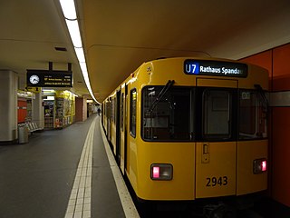
The U7 is a rail line on the Berlin U-Bahn. It runs completely underground for a length of 31.8 kilometres (19.8 mi) through 40 stations and connects Spandau, via Neukölln, to Gropiusstadt and Rudow. The U7 was originally the south-eastern branch of the Nord-Süd-Bahn (U6) that ran between the branching point at Belle-Alliance-Straße (Mehringdamm) and Grenzallee; however, in the 1960s, this stretch was separated from the rest of the line and extended at each end to form a new line.
U8 is a line on the Berlin U-Bahn. It has 24 stations and is 18.1 km (11.2 mi) long. The U8 is one of three north–south Berlin U-Bahn lines, and runs from Wittenau to Neukölln via Gesundbrunnen. The original proposal was for a suspended monorail like the Wuppertal Schwebebahn.
Tegel is a locality (Ortsteil) in the Berlin borough of Reinickendorf on the shore of Lake Tegel. The Tegel locality, the second largest in area of the 96 Berlin districts, also includes the neighbourhood of Saatwinkel.
Heiligensee is a locality within Reinickendorf, a borough of the German capital, Berlin.
Märkisches Viertel is a German locality (Ortsteil) in the borough (Bezirk) of Reinickendorf in Berlin. Its name refers to the March of Brandenburg.
Hermsdorf is a district (Ortsteil) of Berlin located in the borough (Bezirk) of Reinickendorf.
Berlin-Wittenau (in German S-Bahnhof Berlin-Wittenau, officially Wittenau (Wilhelmsruher Damm)) is a railway station in the Wittenau district of Berlin, Germany. It is served by the Berlin S-Bahn and numerous local buses. It is also the northern terminus of the Berlin U-Bahn line U8.
Berlin Karl-Bonhoeffer-Nervenklinik is a railway station in the Reinickendorf borough of Berlin, Germany. It is served by the Berlin S-Bahn, the U8 line of the Berlin U-Bahn and named after the adjacent homonymous psychiatric hospital in Wittenau. The namesake psychiatrist Karl Bonhoeffer (1868–1948) was the father of the resistance fighters Klaus and Dietrich Bonhoeffer. Whereas the hospital and the underground station are located in the locality of Wittenau, the S-Bahn station happens to be in the adjacent Reinickendorf, both localities of the Reinickendorf borough.
Berlin-Waidmannslust is a railway station in the neighbourhood of Waidmannslust, in the city of Berlin, Germany. It is served by the Berlin S-Bahn and by several local buses.
Reinickendorf is a locality of Berlin in the borough of Reinickendorf. It had a population of 83,972 in 2020.
Berlin Tegel is a railway station in Tegel, a locality of the Reinickendorf borough of Berlin. It is served by the S-Bahn line S25.
Heiligensee is a railway station in Heiligensee, a locality in the Reinickendorf borough of Berlin. It is served by the S-Bahn line S25.
Waidmannslust is a German locality (Ortsteil) within the borough (Bezirk) of Reinickendorf, Berlin.
Bus transport is the oldest public transport service in Berlin, the capital city of Germany, having been introduced in 1846. Since 1929, services have been operated by the Berlin Transport Company, although during the Cold War-era division of the city they operated in West Berlin only. In East Berlin the public transport agency split off from the BVG and rebranded as BVB, operating the buses in the Soviet sector of Berlin.
Lübars is a German locality (Ortsteil) within the borough (Bezirk) of Reinickendorf, Berlin.
Wilhelmsruh is a German locality (Ortsteil) within the borough (Bezirk) of Pankow, Berlin. It is the city's smallest locality, after Halensee and Hansaviertel.
Borsigwalde is a German locality (Ortsteil) within the borough (Bezirk) of Reinickendorf, Berlin. Until 2012 was a zone (Ortslage) part of Wittenau.
↑ Michael Zaremba,Reinickendorf im Wandel der Geschichte, Berlin: be.bra, 1999, p.99. ISBN3-930863-63-4.
↑ Reinickendorf, Axel Reibe and Wolfgang Ribbe (eds.), Berlin: Colloquium, 1988, (=Geschichte der Berliner Verwaltungsbezirke; vol.4), pp.69seq. ISBN3-7678-0714-9
↑ Gerd Koischwitz, Sechs Dörfer in Sumpf und Sand – Geschichte des Bezirks Reinickendorf von Berlin, Berlin: Der Nord-Berliner, 1984, pp.81–92. No ISBN
This page is based on this Wikipedia article Text is available under the CC BY-SA 4.0 license; additional terms may apply. Images, videos and audio are available under their respective licenses.