
The Spree is, with a length of approximately 400 kilometres (250 mi), the main tributary of the River Havel. The Spree is much longer than the Havel, which it flows into at Berlin-Spandau; the Havel then flows into the Elbe at Havelberg. The river rises in the Lusatian Highlands, that are part of the Sudetes, in the Lusatian part of Saxony, where it has three sources: the historical one called Spreeborn in the village of Spreedorf, the water-richest one in Neugersdorf, and the highest elevated one in Eibau. The Spree then flows northwards through Upper and Lower Lusatia, where it crosses the border between Saxony and Brandenburg. After passing through Cottbus, it forms the Spree Forest, a large inland delta and Biosphere reserve. It then flows through Lake Schwielochsee before entering Berlin, as Müggelspree(pronounced[ˈmʏɡl̩ˌʃpʁeː] ).

Pankow is the second largest area of Berlin by population. In Berlin's 2001 administrative reform, it was merged with the former boroughs of Prenzlauer Berg and Weißensee; the resulting borough retained the name Pankow. Pankow was sometimes claimed by the Western Allies to be the capital of the German Democratic Republic, while the German Democratic Republic itself considered East Berlin to be its capital.
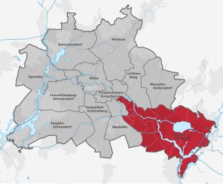
Treptow-Köpenick is the ninth borough of Berlin, Germany, formed in Berlin's 2001 administrative reform by merging the former boroughs of Treptow and Köpenick.

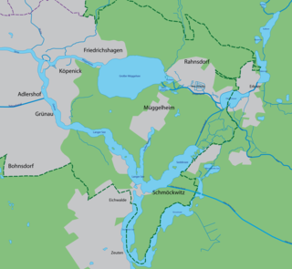
Köpenick is a historic town and locality (Ortsteil) in Berlin, situated at the confluence of the rivers Dahme and Spree in the south-east of the German capital. It was formerly known as Copanic and then Cöpenick, only officially adopting the current spelling in 1931. It is also known for the famous imposter Hauptmann von Köpenick.
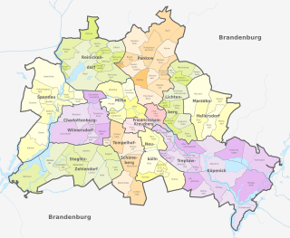
Berlin is divided into boroughs or districts for administration. The boroughs are further divided into neighborhoods which are officially recognised but have no administrative bodies of their own. Neighborhoods typically have strong identities that sometimes pre-date their inclusion into the modern boundaries of Berlin. These function differently to other subdivisions in Germany because of the dual status of Berlin as both a city and a federated state of Germany in its own right.

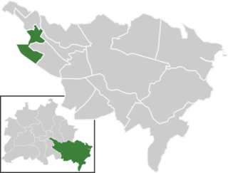
Altglienicke is a locality (Ortsteil) of Berlin in the borough (Bezirk) of Treptow-Köpenick. Until 2001 it was part of the former borough of Treptow.

Berlin has developed a highly complex transportation infrastructure providing very diverse modes of urban mobility. 979 bridges cross 197 kilometers of innercity waterways, 5,334 kilometres (3,314 mi) of roads run through Berlin, of which 73 kilometres (45 mi) are motorways. Long-distance rail lines connect Berlin with all of the major cities of Germany and with many cities in neighboring European countries. Regional rail lines provide access to the surrounding regions of Brandenburg and to the Baltic Sea.

The Zeuthener See is a lake situated to the south-east of Berlin, the capital city of Germany, in the states of Berlin and Brandenburg. At an elevation of 34 metres (112 ft), its surface area is 2.33 square kilometres (0.90 sq mi).

Bohnsdorf is a district in the borough Treptow-Köpenick of Berlin, Germany. It is located in the south-east of the city.

Müggelheim is a German locality (Ortsteil) within the Berlin borough (Bezirk) of Treptow-Köpenick. Until 2001 it was part of the former borough of Köpenick.
Schmöckwitz is a German locality (Ortsteil) within the Berlin borough (Bezirk) of Treptow-Köpenick. Until 2001 it was part of the former borough of Köpenick.

Bus transport is the oldest public transport service in Berlin, the capital city of Germany, having been introduced in 1846. Since 1929, services have been operated by the Berlin Transport Company, although during the Cold War-era division of the city they operated in West Berlin only. In East Berlin the public transport agency split off from the BVG and rebranded as BVB, operating the buses in the Soviet sector of Berlin.

Ferry transport forms part of the transport network of Berlin due to the city's extensive network of rivers, lakes, and canals. 6 routes operate within the city boundaries and one serves the city of Potsdam, which are part of the common public transport tariff run by the Verkehrsverbund Berlin-Brandenburg (VBB).

Rahnsdorf is a locality (Ortsteil) of Berlin, Germany, located in the southeast of the Berlin borough (Bezirk) of Treptow-Köpenick. Until 2001 it was part of the former borough of Köpenick.

Mahlsdorf is a locality (Ortsteil) within the Berlin borough (Bezirk) of Marzahn-Hellersdorf. Until 2001 it was part of the former borough of Hellersdorf.

Friedrichshagen is a German locality (Ortsteil) within the Berlin borough (Bezirk) of Treptow-Köpenick. Until 2001 it was part of the former borough of Köpenick.

Rudow is a locality (Ortsteil) within the Berlin borough (Bezirk) of Neukölln.
Baumschulenweg is a German locality (Ortsteil) within the Berlin borough (Bezirk) of Treptow-Köpenick. Until 2001 it was part of the former borough of Treptow. Its name means road (weg) of the plant nurseries (Baumschulen). It was named after the Späth nursery.

The Gosen Canal is a canal in the eastern suburbs of Berlin, the capital city of Germany. It takes its name from the village Gosen, at the southern end of the canal. It is 4 kilometres (2.5 mi) in length and links the Dämeritzsee and Seddinsee lakes. The Dämeritzsee and Seddinsee are both navigable, with the Seddinsee providing a link to the River Dahme and the Oder-Spree Canal, and the Dämeritzsee providing a link to the Müggelspree reach of the River Spree and to the Flakensee.
The Langer See is a lake situated in the south-eastern outskirts of Berlin, the capital city of Germany. The lake is aligned south-east to north-west and forms part of the course of the River Dahme. The Langer See is approximately 11 kilometres (6.8 mi) long, with an average width of 221 metres (725 ft) and an area of 2.43 square kilometres (0.94 sq mi).


