Berlin Schönefeld Airport was the secondary international airport of Berlin, the capital of Germany. It was located 18 km (11 mi) southeast of Berlin near the town of Schönefeld in the state of Brandenburg and bordered Berlin's southern boundary. It was the smaller of the two airports in Berlin, after Berlin Tegel Airport, and served as an operating base for easyJet and Ryanair. In 2017, the airport handled 12.9 million passengers by serving mainly European metropolitan and leisure destinations. In the same year, the travel portal eDreams ranked Berlin Schönefeld as the worst airport in the world after evaluating 65,000 airport reviews. Schönefeld Airport was the major civil airport of East Germany (GDR) and the only airport of the former East Berlin.

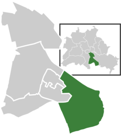
Neukölln is one of the twelve boroughs of Berlin, Germany. It is located south of Berlin's centre and stretches southeastwards to the city boundary, encompassing the localities of Neukölln, Britz, Buckow, Rudow and Gropiusstadt.
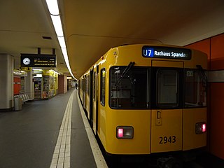
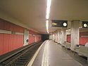
The U7 is a rail line on the Berlin U-Bahn. It runs completely underground for a length of 31.8 kilometres (19.8 mi) through 40 stations and connects Spandau, via Neukölln, to Gropiusstadt and Rudow. The U7 was originally the south-eastern branch of the Nord-Süd-Bahn (U6) that ran between the branching point at Belle-Alliance-Straße (Mehringdamm) and Grenzallee; however, in the 1960s, this stretch was separated from the rest of the line and extended at each end to form a new line.
Rathaus Spandau is the western terminus of Berlin U-Bahn line U7. It was opened on 1 October 1984 with the line's extension from Rohrdamm to Rathaus Spandau. The station takes its name from the nearby Rathaus Spandau, the historic city hall of Spandau.
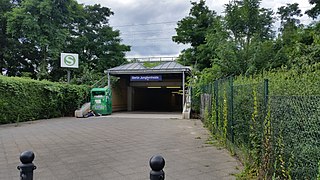
Berlin Jungfernheide is a railway station located at Charlottenburg-Nord, in the Charlottenburg-Wilmersdorf district of Berlin, served by the S-Bahn lines S41 and S42, the U-Bahn line U7 and Regional-Express trains of the Deutsche Bahn. Its name literally translates into "maidens' heathland"; it was named after the Jungfernheide, a former large forest in the proximity of this station.

Britz is a German locality (Ortsteil) within the Berlin borough (Bezirk) of Neukölln.

Schönefeld is a suburban municipality in the Dahme-Spreewald district, Brandenburg, Germany. It borders the southeastern districts of Berlin. The municipal area encompasses the old Berlin Schönefeld Airport (SXF) and the new Berlin Brandenburg Airport (BER).
Rudow is a Berlin U-Bahn station located on the U7 line. There is a bus link to Berlin Schönefeld Airport, served by the line 171 and the express bus X7. Since 2015, the station has been under extended refurbishment to provide a better interchange between buses serving Brandenburg Airport/BER and the trains.

Berlin Hermannstraße is a railway station in the Neukölln district of Berlin. It is served by the S-Bahn lines S41, S42, S45, S46 and S47 and the U-Bahn line U8, of which it is the southern terminus. It was formerly also possible to transfer there to the Neukölln-Mittenwalde railway line, which is now only used for goods traffic.

Altglienicke is a locality (Ortsteil) of Berlin in the borough (Bezirk) of Treptow-Köpenick. Until 2001 it was part of the former borough of Treptow.

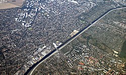
Berlin has developed a highly complex transportation infrastructure providing very diverse modes of urban mobility. 979 bridges cross 197 kilometers of innercity waterways, 5,334 kilometres (3,314 mi) of roads run through Berlin, of which 73 kilometres (45 mi) are motorways. Long-distance rail lines connect Berlin with all of the major cities of Germany and with many cities in neighboring European countries. Regional rail lines provide access to the surrounding regions of Brandenburg and to the Baltic Sea.

Gropiusstadt is a locality within the Berlin borough of Neukölln. It was named after the architect who projected the complex: Walter Gropius.
Johannisthal is a German locality (Ortsteil) within the Berlin borough (Bezirk) of Treptow-Köpenick. Until 2001 it was part of the former borough of Treptow.

Lankwitz is a German locality (Ortsteil) within the borough (Bezirk) of Steglitz-Zehlendorf, Berlin. Until 2001 it was part of the former borough of Steglitz.

Lichtenrade is a German locality (Ortsteil) within the borough (Bezirk) of Tempelhof-Schöneberg, Berlin. Until 2001 it was part of the former borough of Tempelhof.
Buckow is a locality (Ortsteil) within the Berlin borough (Bezirk) of Neukölln.
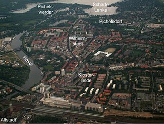
Wilhelmstadt is a German locality (Ortsteil) of Berlin in the borough (Bezirk) of Spandau.
Baumschulenweg is a German locality (Ortsteil) within the Berlin borough (Bezirk) of Treptow-Köpenick. Until 2001 it was part of the former borough of Treptow. Its name means road (weg) of the plant nurseries (Baumschulen). It was named after the Späth nursery.

Waßmannsdorf is a village and a civil parish (Ortsteil) of the German town of Schönefeld, located in the district of Dahme-Spreewald in Brandenburg. As of 2007 its population was of around 1,000.

The Waßmannsdorf station is a stop of the Berlin S-Bahn in Waßmannsdorf in the municipality of Schönefeld on the Grünau Cross–Berlin Brandenburg Airport railway. It was completed in October 2011 and opened on 26 October 2020, five days before Berlin Brandenburg Airport (BER) opened on 31 October 2020. A railway station already existed in the village from 1951 to 1982. It was not located at the same place and was exclusively a depot (Betriebsbahnhof) on the Berlin outer ring.