Frog Bridge

Last updated

Frog Bridge
Frog Bridge in Windham, Connecticut LCCN2012630525.tif
One of the four copper frogs on the bridge
Coordinates 41°42′36″N72°12′34″W / 41.71°N 72.2094°W / 41.71; -72.2094
CarriesSouth St. (CT 661)
Crosses Willimantic River and New England Central Railroad
Official nameThread City Crossing
Named for Named after the city's history with thread mills
Owner Connecticut Department of Transportation
Preceded byAn 1857 stone arch bridge, currently a garden bridge (CT 601)
Characteristics
Design Simple Compression Arch Bridge
Material Steel
Total length476 feet (145 m)
Width66 feet (20 m)
No. of spans1
No. of lanes 4
History
Designer Connecticut Department of Transportation
Constructed byO & G Industries
Construction startMarch 1999 (1999-03)
Construction endFall 2001
Construction cost$13 million
OpenedSeptember 2000 (2000-09)
Location
Frog Bridge

The Frog Bridge (officially known as the Thread City Crossing) is a bridge located in Willimantic, Connecticut which carries South Street (CT 661) across the Willimantic River. It is known as the Frog Bridge because it has four copper frog sculptures on each end of the bridge, sitting on concrete thread spools. The sculptures were designed and created by artist Leo Jensen of Ivoryton, Connecticut. [1] [2] [3]

Contents

Naming

The design of the bridge relates to the local story of the "Battle of the Frogs". In 1754, thousands of bullfrogs in Frog Pond, about a mile east of Windham Center, awoke residents with loud croaking sounds. Many people mistook the sound for war drums or shouted words, and feared it was the French or Indians attacking the small town. [4] [5] [6]

History

Previous bridge

The old bridge Willimantic River with bridge.jpg
The old bridge

The bridge was built to replace an 1857 stone arch bridge located in the middle of the mill complex. The original bridge was planned to be replaced as early as 1872. Another effort to replace the old bridge was made at the turn of the 20th century, but ended up with a compromise resulting in the Willimantic Footbridge. The bridge was closed shortly after the opening of the Frog Bridge, remaining closed until October 2006 when it reopened as the Windham Garden on the Bridge, a pedestrian bridge. [7]

Current bridge

In 1986, then-state legislator John Lescoe introduced a bill to fund a feasibility study for a new bridge over the Willimantic River. The funding was finally approved in 1991.[ citation needed ] The first design for the bridge just had the spools of thread but after the community did not approve it, an architect was hired from the state who added the frogs. The bridge started construction in March 1999 and it opened in September 2000 but full project for the surrounding area was not completed until the Fall of 2001. [8] In 2002, the FHA awarded the Frog Bridge an honorable mention for Excellence in Highway Design in the category of Historic Preservation. [9] [10] [6] The bridge was built over a man-made waterfall which used to provide power for the Jillson Mills. [11]

Design

The Frog Bridge in December 2018 Frog Bridge, December 2018.JPG
The Frog Bridge in December 2018

The bridge is a simple compression iron arch bridge that crosses the Willimantic River and a railroad line owned by the New England Central Railroad. It carries South St. that connects to Route 32 and Route 66. It has 8 concrete thread spools, 4 with green-colored copper frogs, the frogs eye's have gold leaf covering it. The four frogs are named Manny, Willy, Windy and Swifty. [12] Outside of the frogs, the bridge is more like a conventional highway bridge. [1]

The Frog Bridge was depicted in the Bill Griffith's Zippy comic strip in 2001. [13] [14]

Related Research Articles

<span class="mw-page-title-main">Windham County, Connecticut</span> County in Connecticut, United States

Windham County is one of the eight historical counties in the U.S. state of Connecticut, located in its northeastern corner. As of the 2020 census, the population was 116,418, making it the least populous county in Connecticut. It forms the core of the region known as the Quiet Corner. Windham County is included in the Worcester, MA-CT Metropolitan Statistical Area, which is also included in the Boston-Worcester-Providence, MA-RI-NH-CT Combined Statistical Area. The entire county is within the Quinebaug and Shetucket Rivers Valley National Heritage Corridor, as designated by the National Park Service.

<span class="mw-page-title-main">Interstate 91</span> Interstate Highway in the U.S. states of Connecticut, Massachusetts, and Vermont

Interstate 91 (I-91) is an Interstate Highway in the New England region of the United States. It is the primary north–south thoroughfare in the western part of the region. Its southern terminus is in New Haven, Connecticut, at I-95, while the northern terminus is in Derby Line, Vermont, at the Canada–United States border. Past the Derby Line–Rock Island Border Crossing, the road continues into Canada as Quebec Autoroute 55. I-91 is the longest of three Interstate highways whose entire route is located within the New England states and is also the only primary (two-digit) Interstate Highway in New England to intersect all five of the other highways that run through the region. The largest cities along its route, from south to north, are New Haven, Connecticut; Hartford, Connecticut; Springfield, Massachusetts; Northampton, Massachusetts; Greenfield, Massachusetts; Brattleboro, Vermont; White River Junction, Vermont; St. Johnsbury, Vermont; and Newport, Vermont.

<span class="mw-page-title-main">Willimantic, Connecticut</span> Census-designated place in Connecticut, United States

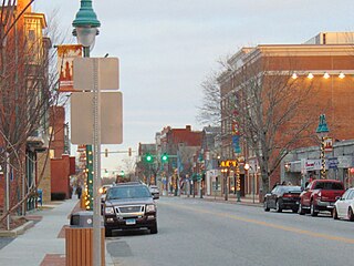
Willimantic is a census-designated place located in Windham, Connecticut. Previously organized as a city and later as a borough, Willimantic is currently one of two tax districts within the Town of Windham. Willimantic is located within Windham County and the Southeastern Connecticut Planning Region. Known as "Thread City" for the American Thread Company's mills along the Willimantic River, it was a center of the textile industry in the 19th century. Originally incorporated as a city in 1893, it entered a period of decline after the Second World War, culminating in the mill's closure and the city's reabsorption into the town of Windham in the 1980s.

<span class="mw-page-title-main">Windham, Connecticut</span> Town in Connecticut, United States

Windham is a town in Windham County, Connecticut, United States. It contains the former city of Willimantic as well as the communities of Windham Center, North Windham, and South Windham. Willimantic, an incorporated city since 1893, was consolidated with the town in 1983. The town is part of the Southeastern Connecticut Planning Region. The population was 24,428 at the 2020 census.

<span class="mw-page-title-main">U.S. Route 5</span> Highway in the United States

U.S. Route 5 (US 5) is a north–south United States Numbered Highway running through the New England states of Connecticut, Massachusetts, and Vermont. Significant cities along the route include New Haven, Connecticut; Hartford, Connecticut; and Springfield, Massachusetts. From Hartford northward to St. Johnsbury, Vermont, the road closely follows the route of the Connecticut River.

<span class="mw-page-title-main">Willimantic River</span> River in Connecticut, United States

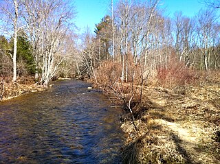
The Willimantic River is a tributary of the Shetucket River, approximately 25 miles (40 km) long in northeastern Connecticut in the New England region of the United States.

<span class="mw-page-title-main">Windham Textile and History Museum</span> Textile museum in Willimantic, Connecticut

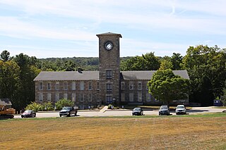
The Windham Textile and History Museum is a museum in Willimantic, Connecticut, in the New England region of the United States. It is currently located in Main St.

<span class="mw-page-title-main">U.S. Route 6 in Connecticut</span> Segment of American highway

U.S. Route 6 (US 6) within the state of Connecticut runs for 116.33 miles (187.21 km) from the New York state line near Danbury to the Rhode Island state line in Killingly. West of Hartford, the route either closely parallels or runs along Interstate 84 (I-84), which has largely supplanted US 6 as a through route in western Connecticut. East of Hartford, US 6 serves as a primary route for travel between Hartford and Providence.

<span class="mw-page-title-main">Connecticut Route 14</span> State highway in Windham County, Connecticut, US

Connecticut Route 14 is one of several secondary routes from eastern Connecticut into Rhode Island. It runs from the Willimantic section of the town of Windham to the Rhode Island state line in Sterling.

<span class="mw-page-title-main">Air Line State Park Trail</span> Rail trail in Connecticut, US

Air Line State Park Trail is a rail trail and linear state park located in Connecticut. The trail is divided into sections designated South, North a piece of the East Coast Greenway, and the Thompson addition. An additional 3.6-mile spur to Colchester is sometimes designated as part of the Air Line trail. At the Massachusetts state line, the trail connects to the Southern New England Trunkline Trail, a 22-mile-long trail to Franklin, MA built on the same right-of-way. Since 2018, the town of Portland, Connecticut has also maintained a 2.3-mile portion of the Air Line trail, connecting to the southern end of the state park at the town line with East Hampton.

<span class="mw-page-title-main">Hop River State Park Trail</span> Recreation rail trail in Connecticut, United States

Hop River State Park Trail is a Connecticut rail trail that winds for 20.8 miles (33.5 km) eastward from Colonial Drive in the town of Manchester to the Air Line State Park Trail S. in the town of Windham. The trail parallels the Hop River for much of its length. It is owned and operated by the Connecticut Department of Energy and Environmental Protection, with upgrades and maintenance done by town forces and community volunteer groups in coordination with the state. The trail is used for hiking, biking, horseback riding, and cross-country skiing.

<span class="mw-page-title-main">Connecticut Route 203</span> State highway in Windham County, Connecticut, US

Route 203 is a state highway in eastern Connecticut, running entirely within the town of Windham.

<span class="mw-page-title-main">Connecticut Route 195</span> State highway in northeastern Connecticut, US

Route 195 is a state highway in northeastern Connecticut, running from the Willimantic section of Windham to the town center of Tolland via the Storrs section of Mansfield. The road is the main thoroughfare to access the main campus of the University of Connecticut.

<span class="mw-page-title-main">Interstate 84 in Connecticut</span> Highway in Connecticut

Interstate 84 (I-84) is an east–west Interstate Highway across the state of Connecticut through Danbury, Waterbury, Hartford, and Union.
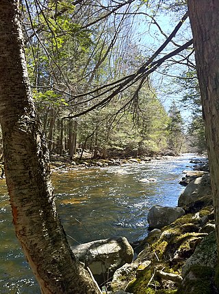
<span class="mw-page-title-main">Natchaug School</span> Public school in Willimantic, , Connecticut, United States

Natchaug Elementary School is a public elementary school in Willimantic, Connecticut, United States. The school opened in 1865 at the junction of Milk Street and Jackson Street, in downtown Willimantic. It is part of the Windham Public School system and one of four elementary schools and a K-8 STEM magnet school. Natchaug is accredited by the New England Association of Schools and Colleges. The name Natchaug comes from the Nipmuc word meaning "land between the rivers." The school colors are bright green and blue.

<span class="mw-page-title-main">Fenton River</span>

The Fenton River is a major water source for the University of Connecticut that runs through Mansfield, Storrs, and Willington, as well as small parts of Windham, all but the latter in Tolland County, Connecticut. spanning 18.895 miles. It feeds into Mansfield Hollow reservoir at its end, making it a tributary to the Mount Hope, Natchaug, and Willimantic rivers. The Fenton River is fed by several smaller brooks, streams, and creeks. It is used as a water source by the University of Connecticut Storrs Campus, and is as thus relatively shallow.

<span class="mw-page-title-main">Jillson Mills</span> Mill complex in Connecticut, U.S.

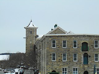
The Jillson Mills is a mill complex in Willimantic, Connecticut. The mills produced cotton thread throughout the lifespan of the operation of the mill.

<span class="mw-page-title-main">Windham Town Hall</span> Town hall in Connecticut, United States

The Windham Town Hall is a town hall in Willimantic, Windham, Connecticut, United States.

<span class="mw-page-title-main">Jillson Square Park</span>

Jillson Square Park is park located in Willimantic, Connecticut. It holds the William Jillson Stone House on its area, and is home to the Willimantic Carnival. The park was created after the Windham Historical Society bought the property in 1972, and gave the area to the Town of Windham Recreation Department for park development. The park was the former land of William Jillson, the creator of the Jillson Mills nearby. The Air Line Trail starts less than 200 feet (61 m) away from here.

<span class="mw-page-title-main">Battle of the Frogs</span> Local legend in Windham, Connecticut

The Battle of the Frogs is a local legend concerning an incident in the Connecticut Colony town of Windham in 1754.

References

  1. 1 2 Bendici, Ray. "The Frog Bridge, Willimantic". Damned Connecticut. Archived from the original on October 19, 2016. Retrieved September 20, 2016.
  2. Pelland, Dave (August 23, 2011). "Frog Bridge, Willimantic". CT Monuments.net. Archived from the original on October 4, 2011. Retrieved September 20, 2016.
  3. Boyer, Crispin (March 13, 2012). National Geographic Kids Ultimate U. S. Road Trip Atlas: Maps, Games, Activities, and More for Hours of Backseat Fun. National Geographic Books. ISBN   9781426309335. Archived from the original on December 29, 2021. Retrieved December 29, 2021.
  4. "The Battle of the Frogs". Windham Historical Society. Archived from the original on October 18, 2016. Retrieved September 20, 2016.
  5. "Bridge Ornaments Help Tell the Legend of the Windham Frog Fight". ConnecticutHistory.org. Archived from the original on July 6, 2014. Retrieved September 20, 2016.
  6. 1 2 D'Agostino, Thomas; Nicholson, Arlene (August 16, 2011). Connecticut Ghost Stories and Legends. Arcadia Publishing. ISBN   9781614237938. Archived from the original on December 29, 2021. Retrieved December 29, 2021.
  7. "Windham Garden on the Bridge - Willimantic, CT". Willimantic River Alliance. Archived from the original on September 6, 2016. Retrieved April 23, 2018.
  8. Polk, Nancy (December 3, 2000). "Once Again, Frogs Land in Willimantic". The New York Times . Archived from the original on June 22, 2018. Retrieved June 22, 2018.
  9. "2002 Thread City Crossing 'The Frog Bridge', Willimantic, Connecticut - 2002 Awards - Excellence in Highway Design - Design Standards - Design". Federal Highway Administration. Archived from the original on October 18, 2016. Retrieved September 20, 2016.
  10. Steve (November 3, 2007). "Frog Bridge (Willimantic)". CTMQ. Archived from the original on October 31, 2020. Retrieved August 4, 2023.
  11. "Thread City Crossing". ThreadCity.com. Archived from the original on March 16, 2017. Retrieved March 15, 2017.
  12. Curland, Richard (February 25, 2018). "Historically Speaking: Bridge's frogs have roots in Willimantic's past". The Bulletin. Archived from the original on August 4, 2023. Retrieved August 4, 2023.
  13. "Frog Bridge". CTMQ. November 3, 2007.
  14. Landrigan, Leslie (May 18, 2015). "The Great Windham Frog Fight of 1754". New England Historical Society.