
The San Francisco Peninsula is a peninsula in the San Francisco Bay Area that separates San Francisco Bay from the Pacific Ocean. On its northern tip is the City and County of San Francisco. Its southern base is Los Altos, Mountain View, in Santa Clara County, south of Palo Alto and north of Sunnyvale and Los Altos. Most of the Peninsula is occupied by San Mateo County, between San Francisco and Santa Clara counties, and including the cities and towns of Atherton, Belmont, Brisbane, Burlingame, Colma, Daly City, East Palo Alto, El Granada, Foster City, Hillsborough, Half Moon Bay, La Honda, Loma Mar, Los Altos, Menlo Park, Millbrae, Mountain View, Pacifica, Palo Alto, Pescadero, Portola Valley, Redwood City, San Bruno, San Carlos, San Mateo, South San Francisco, and Woodside.

San Francisco, officially the City and County of San Francisco, is a commercial, financial, and cultural center in Northern California. With a population of 808,437 residents as of 2022, San Francisco is the fourth most populous city in the U.S. state of California. The city covers a land area of 46.9 square miles at the end of the San Francisco Peninsula, making it the second-most densely populated large U.S. city after New York City and the fifth-most densely populated U.S. county, behind only four New York City boroughs. Among the 92 U.S. cities proper with over 250,000 residents, San Francisco is ranked first by per capita income and sixth by aggregate income as of 2022.
Pacifica is a city in San Mateo County, California, on the coast of the Pacific Ocean between San Francisco and Half Moon Bay.

Mission Beach is a community built on a sandbar between the Pacific Ocean and Mission Bay. It is part of the city of San Diego, California.

Belmont Park is an oceanfront historic amusement park located in the Mission Beach area of San Diego, California. The park was developed by sugar magnate John D. Spreckels and opened on July 4, 1925 as the Mission Beach Amusement Center. In addition to providing recreation and amusement, it also was intended as a way to help Spreckels sell land in Mission Beach. Located on the beach, it attracts millions of people each year.

The Golden Gate National Recreation Area (GGNRA) is a U.S. National Recreation Area protecting 82,116 acres (33,231 ha) of ecologically and historically significant landscapes surrounding the San Francisco Bay Area. Much of the park is land formerly used by the United States Army. GGNRA is managed by the National Park Service and is the second-most visited unit of the National Park system in the United States, with more than 15.6 million visitors in 2022. It is also one of the largest urban parks in the world, with a size two-and-a-half times that of the consolidated city and county of San Francisco.

The Golden Gate International Exposition (GGIE) (1939 and 1940), held at San Francisco's Treasure Island, was a World's Fair celebrating, among other things, the city's two newly built bridges. The San Francisco–Oakland Bay Bridge opened in 1936 and the Golden Gate Bridge in 1937. The exposition opened from February 18, 1939, through October 29, 1939, and from May 25, 1940, through September 29, 1940; it drew 17 million visitors to Treasure Island.

Capuchino High School is a public high school in San Bruno, California, United States. It is one of seven high schools in the San Mateo Union High School District, a division of the San Mateo County Office of Education.
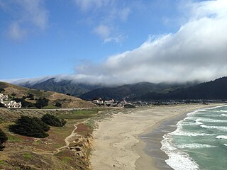
Pacifica State Beach is the southernmost of Pacifica, California's large beaches. It is a 0.75-mile-long (1.21 km) crescent-shaped beach located at the mouth of the San Pedro Valley in downtown Pacifica off State Route 1, in San Mateo County. Over one million people visit this beach annually.

The Sánchez Adobe Park, home to the Sánchez Adobe, is located in Pacifica, California, at 1000 Linda Mar Boulevard, on the north bank of San Pedro Creek, approximately 0.91 miles (1,470 m) from the Pacific Ocean in Linda Mar Valley. The 5.46-acre (2.21 ha) county park, established in 1947 contains the Sanchez Adobe Historical site, designated a National Register Historical District in 1976 and is California registered landmark 391.

The Ocean Shore Railroad was a railroad built between San Francisco and Tunitas Glen, and Swanton and Santa Cruz that operated along the Pacific coastline from 1905 until 1921. The route was originally conceived to be a continuous line between San Francisco and Santa Cruz, but the 1906 San Francisco Earthquake, financial difficulties, and the advent of the automobile caused the line to never reach its goals, and remain with a Northern and Southern division.

Pedro Mountain Road describes a series of historical road crossings of Pedro Mountain, a promontory ridge located between Montara Mountain and the coastal cliffs of Devil's Slide in San Mateo County, California. This Pedro Mountain headland blocks the easy passage of coastal travelers between the Pedro Valley in Pacifica, California and Montara, California. The most prominent of these Pedro Mountain roads was Coastside Boulevard, the 1914 to 1937 coastal highway 57, which remains in use today as part of the trail network of McNee Ranch State Park.

Montara Mountain, positioned between the unincorporated community of Montara, California, to the southwest and the city of Pacifica, California, to the north, forms the northern spur of the Santa Cruz Mountains, a narrow mountain range running the length of the San Francisco Peninsula that separates San Francisco Bay from the Pacific Ocean. Its highest point rises to 1,898 feet (579 m) above sea level. Montara and Pacifica are connected by the Tom Lantos Tunnels, which run through the Mountain.

Extreme Pizza, Inc. is a privately held restaurant franchise chain specializing in conventional and California-style pizza, founded by Todd Parent and Michael Pastor in 1994 in San Francisco, California. The chain currently includes over 30 locations in the United States; a previous location in Ireland has now closed. 24 franchises are located in Central California. Others are present in Boise, Idaho; McAllen, Texas; Clearwater Beach, Florida; Grosse Pointe, Michigan; Wantage, New Jersey; and Charlottesville and Henrico, Virginia. Entrepreneur Ernest Harris has recently brought the franchise to Northern Virginia, opening locations in Pentagon City and Arlington County. The company primarily sells pizza; other menu items include calzones, sandwiches, and salads.

Pilarcitos Creek is a 13.5-mile-long (21.7 km) coastal stream in San Mateo County, California, United States, that rises on the western slopes of the Santa Cruz Mountains and descends through Pilarcitos Canyon to discharge into the Pacific Ocean Half Moon Bay State Beach.
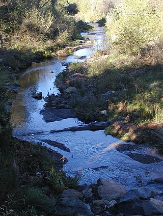
San Pedro Creek is a perennial stream in the City of Pacifica, San Mateo County, California, in the San Francisco Bay Area whose tributaries originate on Sweeney Ridge in the Golden Gate National Recreation Area and Montara Mountain in the Santa Cruz Mountains.The creek mainstem flows 2.5 miles (4.0 km) through the San Pedro Valley to its mouth near Shelter Cove of the Pacific Ocean The stream is notable as the 1769 campsite for Gaspar de Portolà before he ascended Sweeney Ridge and discovered San Francisco Bay.

San Pedro Valley County Park is a San Mateo County park located in Pacifica, California, which includes the headwaters of San Pedro Creek.
Rancho San Pedro was a 8,926-acre (36.12 km2) Mexican land grant in present-day San Mateo County, California given in 1839 by Governor Juan Alvarado to Francisco Sanchez. The grant encompasses present-day Pacifica.
Marinscope Community Newspapers is a chain of six weekly newspapers in Marin County, California.

The Rockaway Quarry was a Calera limestone quarry in Pacifica, California, in the San Francisco Bay Area. Limestone from the site was first extracted by Ohlone from the village of Pruristac. Beginning in 1776, New Spaniards used California Indian labor to mine limestone and build structures like the Presidio and San Francisco missions. After the 1906 earthquake, the quarry's limestone was used to rebuild San Francisco. By the 1960s, operations declined, and the quarry permanently closed in 1987. Today it is privately held but is used as an informal hiking trail.

