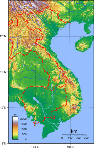
Vietnam is located on the eastern margin of the Indochinese peninsula and occupies about 331,211.6 square kilometres (127,881.5 sq mi), of which about 25% was under cultivation in 1987. It borders the Gulf of Tonkin, Gulf of Thailand, and Pacific Ocean, along with China, Laos, and Cambodia. The elongated roughly S shaped country has a north-to-south distance of 1,650 km (1,030 mi) and is about 50 km (31 mi) wide at the narrowest point. With a coastline of 3,260 km (2,030 mi), excluding islands, Vietnam claims 12 nautical miles as the limit of its territorial waters, an additional 12 nautical miles as a contiguous customs and security zone. It has an exclusive economic zone of 417,663 km2 (161,261 sq mi) with 200 nautical miles.
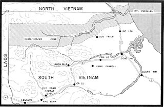
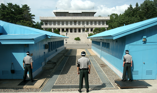
A demilitarized zone is an area in which treaties or agreements between states, military powers or contending groups forbid military installations, activities, or personnel. A DZ often lies along an established frontier or boundary between two or more military powers or alliances. A DZ may sometimes form a de facto international border, such as the Korean Demilitarized Zone. Other examples of demilitarized zones are a 9-mile wide area between Iraq and Kuwait; Antarctica ; and outer space.
Borders are usually defined as geographical boundaries, imposed either by features such as oceans and terrain, or by political entities such as governments, sovereign states, federated states, and other subnational entities. Political borders can be established through warfare, colonization, or mutual agreements between the political entities that reside in those areas.

West Asia, also called Western Asia or Southwest Asia, is the westernmost region of Asia. As defined by most academics, UN bodies and other institutions, the subregion consists of Anatolia, the Arabian Peninsula, Iran, Mesopotamia, the Armenian highlands, the Levant, the island of Cyprus, the Sinai Peninsula, and the southern part of the Caucasus Region (Transcaucasia). The region is separated from Africa by the Isthmus of Suez in Egypt, and separated from Europe by the waterways of the Turkish Straits and the watershed of the Greater Caucasus. Central Asia lies to its northeast, while South Asia lies to its east. Twelve seas surround the region (clockwise): the Aegean Sea, the Sea of Marmara, the Black Sea, the Caspian Sea, the Persian Gulf, the Gulf of Oman, the Arabian Sea, the Gulf of Aden, the Red Sea, the Gulf of Aqaba, the Gulf of Suez, and the Mediterranean Sea. The area contains the vast majority of the similarly defined Middle East, but excluding most of Egypt and the northwestern part of Turkey, and including the southern part of the Caucasus.

Southern Europe is the southern region of Europe. It is also known as Mediterranean Europe, as its geography is marked by the Mediterranean Sea. Definitions of southern Europe include some or all of these countries and regions: Albania, Andorra, Bosnia and Herzegovina, Bulgaria, Croatia, Cyprus, Gibraltar, Greece, Italy, Kosovo, Malta, Monaco, Montenegro, North Macedonia, Portugal, San Marino, Serbia, Slovenia, southern France, Spain, Turkey, and Vatican City.
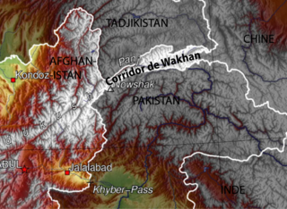
The Wakhan Corridor is a narrow strip of territory located within the Badakhshan province of Afghanistan. This corridor stretches eastward, connecting Afghanistan to Xinjiang, China. It also separates the Gorno-Badakhshan Autonomous Region of Tajikistan in the north from northern Pakistan in the south. This high mountain valley serves as the source of both the Panj and Pamir rivers, which converge to form the larger Amu River. For countless centuries, a vital trade route has traversed this valley, facilitating the movement of travelers to and from East, South, and Central Asia.

Kandal is a province of Cambodia located in the southeast portion of the country. It completely surrounds the Cambodian capital of Phnom Penh and borders the provinces of Kampong Speu and Takéo to the west, Kampong Chhnang and Kampong Cham to the north, Prey Veng to the east, and shares an international border with Vietnam to the south. It is the second most populous province in Cambodia after the capital Phnom Penh. Its capital and largest city is Ta Khmau, which is approximately eight kilometres (5.0 mi) south of central Phnom Penh. Kandal is one of the wealthier provinces in the country.

An exclusive economic zone (EEZ), as prescribed by the 1982 United Nations Convention on the Law of the Sea, is an area of the sea in which a sovereign state has exclusive rights regarding the exploration and use of marine resources, including energy production from water and wind. EEZ does not define the ownership of any maritime features within the EEZ.

Europe is traditionally defined as one of seven continents. Physiographically, it is the northwestern peninsula of the larger landmass known as Eurasia ; Asia occupies the centre and east of this continuous landmass. Europe's eastern frontier is usually delineated by the Ural Mountains in Russia, which is the largest country by land area in the continent. The southeast boundary with Asia is not universally defined, but the modern definition is generally the Ural River or, less commonly, the Emba River. The boundary continues to the Caspian Sea, the crest of the Caucasus Mountains, and on to the Black Sea. The Bosporus, the Sea of Marmara, and the Dardanelles conclude the Asian boundary. The Mediterranean Sea to the south separates Europe from Africa. The western boundary is the Atlantic Ocean. Iceland is usually included in Europe because it is over twice as close to mainland Europe as mainland North America. There is ongoing debate on where the geographical centre of Europe falls.

Geography of Asia reviews geographical concepts of classifying Asia, the central and eastern part of Eurasia, comprising 58 countries and territories.

Determining the boundaries between the continents is generally a matter of geographical convention. Several slightly different conventions are in use. The number of continents is most commonly considered seven but may range as low as four when Afro-Eurasia and the Americas are both considered as single continents. An island can be considered to be associated with a given continent by either lying on the continent's adjacent continental shelf or being a part of a microcontinent on the same principal tectonic plate. An island can also be entirely oceanic while still being associated with a continent by geology or by common geopolitical convention. Another example is the grouping into Oceania of the Pacific Islands with Australia and Zealandia.

The largest enlargement of the European Union (EU), in terms of number of states and population, took place on 1 May 2004.
The Treaties of Erzurum were two treaties of 1823 and 1847 that settled boundary disputes between the Ottoman Empire and Persia.

A maritime boundary is a conceptual division of Earth's water surface areas using physiographical or geopolitical criteria. As such, it usually bounds areas of exclusive national rights over mineral and biological resources, encompassing maritime features, limits and zones. Generally, a maritime boundary is delineated at a particular distance from a jurisdiction's coastline. Although in some countries the term maritime boundary represents borders of a maritime nation that are recognized by the United Nations Convention on the Law of the Sea, maritime borders usually serve to identify the edge of international waters.

The Congo–Nile Divide or the Nile–Congo Watershed is the continental divide that separates the drainage basins of the Congo and Nile rivers. It is about 2,000 kilometres (1,200 mi) long.

The Cambodia–Thailand border is the international border between Cambodia and Thailand. The border is 817 km (508 mi) in length and runs from the tripoint with Laos in the north-east to the Gulf of Thailand in the south.

The Cambodia–Vietnam border is the international border between the territory of Cambodia and Vietnam. The border is 1,158 km in length and runs from the tripoint with Laos in the north to Gulf of Thailand in the south.