
Fugalei is an islet of Wallis and Futuna. It is located off the east coast of Mata-Utu, Wallis Island. [1]
Fugalei is an islet of Wallis and Futuna. It is located off the east coast of Mata-Utu, Wallis Island. [1]

Wallis and Futuna, officially the Territory of the Wallis and Futuna Islands, is a French island collectivity in the South Pacific, situated between Tuvalu to the northwest, Fiji to the southwest, Tonga to the southeast, Samoa to the east, and Tokelau to the northeast.

Briarcliff is a second-class city in Baxter County, Arkansas, United States. The population was 236 at the 2010 census.
Olive Township is a civil township of Ottawa County in the U.S. state of Michigan. The population was 4,735 at the 2010 census.
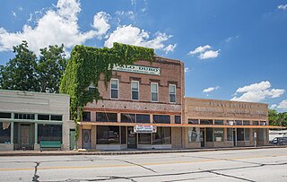
Wallis is a city in far southeastern Austin County, Texas, United States. The city is located along State Highway 36 (SH 36) and the BNSF Railway between Rosenberg and Sealy. The city's population was 1,292 at the 2020 census.

Orchard is a city in western Fort Bend County, Texas, United States, within the Houston–Sugar Land–Baytown metropolitan area. The community is located along State Highway 36 (SH 36) and the BNSF Railway between Rosenberg in Fort Bend County and Wallis in Austin County. The population was 352 at the 2010 census, down from 408 at the 2000 census.

U.S. Route 176 is a spur of US 76 in the U.S. states of North Carolina and South Carolina. The U.S. Highway runs 237.98 miles (382.99 km) from US 25 Business and North Carolina Highway 225 in Hendersonville, North Carolina, east to US 52 in Goose Creek, South Carolina. US 176 serves the transition region between the Blue Ridge Mountains and Foothills of Western North Carolina and the Upstate, Midlands, and Lowcountry regions of South Carolina. The highway passes through and connects Spartanburg, one of two major cities in the Upstate, and Columbia, the South Carolina state capital and central city of the Midlands. US 176 parallels and serves as a secondary highway to Interstate 26 (I-26) except for between Spartanburg and Columbia, where the U.S. Highway deviates from the I-26 corridor to serve Union.

Wallis is a Polynesian atoll/island in the Pacific Ocean belonging to the French overseas collectivity of Wallis and Futuna. It lies north of Tonga, northeast of Fiji, east-northeast of the Hoorn Islands, east of Fiji's Rotuma, southeast of Tuvalu, southwest of Tokelau and west of Samoa. Its area is almost 100 km2 (39 sq mi) with 8,333 people. Its capital is Mata Utu. Roman Catholicism is the predominant religion. Its highest point is Mount Lulu Fakahega. Wallis is of volcanic origin with fertile soil and some remaining lakes. Rainfall is plentiful.

Mata Utu is the capital city of Wallis and Futuna, an overseas collectivity of France. It is located on the island of Uvéa (ʻUvea), in the district of Hahake, of which it is also the capital. It is one of two ports in Wallis and Futuna, the other being at Leava on Futuna. Hihifo Airport, the main airport serving the island and city, is 5.6 kilometres (3.5 mi) to the northwest. Its population was 1,029 in 2018, up from 815 in 1998.
Stade de Mata Utu, also Stade de Kafika is a multi-use stadium in Mata Utu, Wallis Island, Wallis and Futuna. It is currently used mostly for football matches. The stadium holds 1,500 people.

Hakake is one of the 5 districts of Wallis and Futuna, located in Wallis Island, in the Pacific Ocean. It is part of the Chiefdom of Uvea.
The Roman Catholic Diocese of Wallis et Futuna in Wallis and Futuna is a suffragan diocese of the Roman Catholic Archdiocese of Nouméa. It was erected as a Vicariate Apostolic in 1935 and elevated to a diocese in 1966. The Bishop of Wallis et Futuna is a member of the Episcopal Conference of the Pacific.
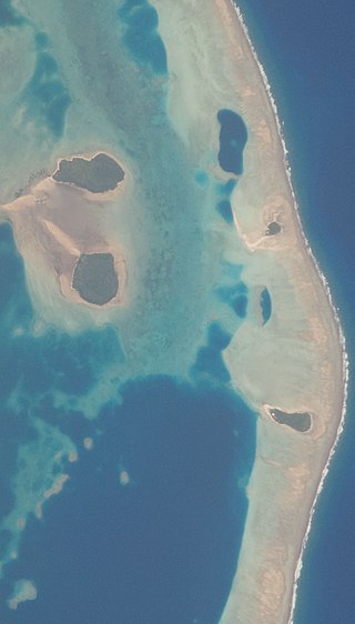
Luaniva is an islet of Wallis and Futuna. It is located off the east coast of Mata-Utu, Wallis Island.
Nukuhione is an islet of Wallis and Futuna. It is located off the east coast of Mata-Utu, Wallis Island.
Nukuhifala is an islet of Wallis and Futuna. It is located off the east coast of Mata-Utu, Wallis Island. The only settlement is a tiny hamlet on the southwest coast. It lies on the outer coral reef. It has a population of four.
Stade Laione Rugby is a stadium in Mata-Utu, Wallis Island, Wallis and Futuna.
Stade Lomipeau is a stadium in Mata-Utu, Wallis Island, Wallis and Futuna.

Mua is one of the 5 districts of Wallis and Futuna, located in Wallis Island, in the Pacific Ocean. It is part of the Chiefdom of Uvea.

Skaplizo Glacier is 2 nautical miles long and 0.8 nautical miles wide glacier on the west side of Urda Ridge on Clarence Island in the South Shetland Islands, Antarctica situated south of Giridava Glacier. It drains the slopes of Mount Irving and Duclos-Guyot Bluff, flows west-northwestwards and enters the Southern Ocean northeast of Chichil Point.
Coordinates: 13°16′50″S176°8′47″W / 13.28056°S 176.14639°W
| | This Wallis and Futuna location article is a stub. You can help Wikipedia by expanding it. |