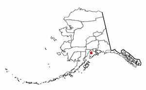
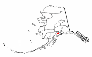
Kenai Peninsula Borough is a borough of the U.S. state of Alaska. As of the 2020 census, the population was 58,799, up from 55,400 in 2010. The borough seat is Soldotna, the largest city is Kenai, and the most populated community is the census-designated place of Kalifornsky.
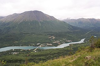
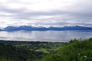
Cooper Landing is a census-designated place (CDP) in Kenai Peninsula Borough, Alaska, United States, about 100 miles (160 km) south of Anchorage, at the outlet of Kenai Lake into the Kenai River. The town was first settled in the 19th century by gold and mineral prospectors, and has become a popular summer tourist destination thanks to its scenic location and proximity to the salmon fishery of the Kenai River and Russian River. As of the 2010 census, the population in Cooper Landing was 289, down from 369 in 2000.
Funny River is a census-designated place (CDP) in Kenai Peninsula Borough, Alaska, United States. At the 2010 census the population was 877, up from 636 in 2000.

Kalifornsky is a census-designated place (CDP) in Kenai Peninsula Borough, Alaska, United States. The population was 8,487 at the 2020 census, up from 7,850 in 2010. It is the most populated locality in the borough.

Kenai is a city in the Kenai Peninsula Borough in the U.S. state of Alaska. By road, it is 158 miles southwest of Anchorage. The population was 7,424 as of the 2020 census, up from 7,100 in 2010, the fifteenth-most populated city in the state.

Soldotna is a city in the Kenai Peninsula Borough in the U.S. state of Alaska. At the 2020 census, the population was 4,342, up from 4,163 in 2010. It is the seat of the Kenai Peninsula Borough.
Sterling is a census-designated place (CDP) in Kenai Peninsula Borough, Alaska, United States. At the 2020 census the population was 5,918, up from 5,617 in 2010. Sterling is the tenth-most populated CDP in Alaska.

The Kenai Peninsula is a large peninsula jutting from the coast of Southcentral Alaska. The name Kenai is derived from the word "Kenaitze" or "Kenaitze Indian Tribe", the name of the Native Athabascan Alaskan tribe, the Kahtnuht’ana Dena’ina, who historically inhabited the area. They called the Kenai Peninsula Yaghanen.
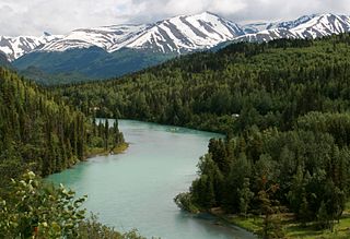
The Kenai River called Kahtnu in the Dena'ina language, is the longest river in the Kenai Peninsula of southcentral Alaska. It runs 82 miles (132 km) westward from Kenai Lake in the Kenai Mountains, through the Kenai National Wildlife Refuge and Skilak Lake to its outlet into the Cook Inlet of the Pacific Ocean near Kenai and Soldotna.

The Denaʼina, or formerly Tanaina, are an Alaska Native Athabaskan people. They are the original inhabitants of the south central Alaska region ranging from Seldovia in the south to Chickaloon in the northeast, Talkeetna in the north, Lime Village in the northwest and Pedro Bay in the southwest. The Denaʼina homeland is more than 41,000 sq mi (110,000 km2) in area. They arrived in the south-central Alaska sometime between 1,000 and 1,500 years ago. They were the only Alaskan Athabaskan group to live on the coast. The Denaʼina have a hunter-gatherer culture and a matrilineal system. The Iditarod Trail's antecedents were the native trails of the Denaʼina and Deg Hitʼan Athabaskan Native Alaskans and the Inupiaq Inuit.

The Kenai National Wildlife Refuge is a 1.92-million-acre (7,770 km2) wildlife habitat preserve located on the Kenai Peninsula of Alaska, United States. It is adjacent to Kenai Fjords National Park. This refuge was created in 1941 as the Kenai National Moose Range, but in 1980 it was changed to its present status by the Alaska National Interest Lands Conservation Act. The refuge is administered from offices in Soldotna. The Kenai Wilderness protects 1,354,247 acres of the refuge as wilderness area.
The Caribou Hills Fire was a 2007 wildfire that burned near Ninilchik, Alaska, and expanded extremely rapidly, making it at one point the top firefighting priority in the United States. It soon moved toward the town and at its peak threatened approximately 300 structures.
Skyview High School was a four-year public school, serving grades 9 through 12. The school is located along the Sterling Highway in Kalifornsky, Alaska, a short distance south of Soldotna city limits and directly west of the boundary of the Kenai National Wildlife Refuge. The school's attendance area covered an approximately 75–mile stretch of the Sterling Highway, from Tern Lake to Cohoe. This area includes Cooper Landing and Kasilof, and portions of Kalifornsky, Soldotna and Sterling. The remainder of the central Kenai Peninsula was served by Soldotna High School and Kenai Central High School.
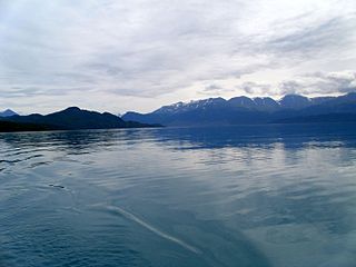
Skilak Lake is a large lake on the Kenai Peninsula, Alaska. The lake is part of the Kenai River system but also contains glacial runoff, being fed by meltwater from Skilak Glacier. The water is exceptionally clear with a mostly rocky bottom, relatively free of aquatic vegetation. It is within the Kenai National Wildlife Refuge, and can be accessed by Skilak Lake Loop Road via the Sterling Highway. Maximum depth is 632 feet (193 m), it is 15 miles (24 km) long and up to 4 miles (6.4 km) wide in places. Early Russian explorers mistakenly believed Skilak and Tustumena Lake to be a single body of water. It is a popular destination for Alaskans due to it being only about a half-hour drive from Soldotna, and approximately two hours from Anchorage. There are two campgrounds at the lake, one is a developed campground with a host, the other un-hosted and with only basic facilities. There are many well-developed and maintained trails along the lake and its access road, as well as campgrounds and public-access cabins.

The Shanta Creek Wildfire was a lightning caused forest fire that started on June 29, 2009, in the Kenai National Wildlife Refuge on the Kenai Peninsula of Alaska. More than 13,000 acres were burned and over 400 personnel were involved in the firefighting effort.

Soldotna Airport is a city-owned, public use airport located one nautical mile (1.85 km) southeast of the central business district of Soldotna, Alaska.

The Kenai Spur Highway is a 39-mile-long (63 km) highway on the Kenai Peninsula in the U.S. state of Alaska. The road begins at a junction with the Sterling Highway in Soldotna and provides access to the towns of Kenai and Nikiski, dead-ending at the entrance to the Captain Cook State Recreation Area. Visitors traveling between the Homer area and these areas can bypass Soldotna and access the Spur Highway via Kalifornsky Beach Road. The highway is a four-lane undivided road inside of the cities of Soldotna and Kenai and a two-lane road elsewhere. The northern section of the road is also known as the North Kenai Road. In 2018, the Federal Highway Administration approved a plan to extend the road by eight miles to improve access to remote homes in the area.
Skyview Middle School is a public middle school serving grades 7–8 in Soldotna, Alaska, under the jurisdiction of the Kenai Peninsula Borough School District. The school's mascot is the panther, and the colors are purple and white. The school serves the student population of the central Kenai Peninsula from miles 75.5–110 of the Sterling Highway, and the communities of Soldotna, Kasilof, Sterling, and Cooper Landing. The school receives students from Soldotna, Sterling, Redoubt, Tustumena, and Kalifornsky Beach Elementary schools, as well as Soldotna Montessori School.

The Miller’s Reach Fire, also known as the Big Lake Fire, was a wildfire that began on June 2, 1996 in an area around Miller’s Reach Road near Houston, Alaska, approximately 33 miles (53 km) north of Anchorage, Alaska. The fire burned over 37,000 acres (15,000 ha), destroyed at least 344 structures, and caused more than $10 million in damage to structures and property. The fire was at the time the most destructive in Alaska history, consuming more structures than all other wildfires in Alaskan history combined. 37 fire departments and 1,800 firefighting and support personnel responded to the fire. It took nearly two weeks to completely control the fire.

The Swan Lake Fire was a large lightning-caused wildfire that burnt between Sterling and Cooper Landing on the Kenai Peninsula in Alaska from June 5, 2019, until the autumn of that year. In total, the fire burned approximately 170,000 acres.

