
Funchal is the largest city, the municipal seat and the capital of Portugal's Autonomous Region of Madeira, bordered by the Atlantic Ocean. The city has a population of 105,795, making it the sixth largest city in Portugal. Because of its high cultural and historical value, Funchal is one of Portugal's main tourist attractions; it is also popular as a destination for New Year's Eve, and it is the leading Portuguese port on cruise liner dockings.
São Miguel Island, nicknamed "The Green Island", is the largest and most populous island in the Portuguese archipelago of the Azores. The island covers 760 km2 (290 sq mi) and has around 140,000 inhabitants, with 45,000 people residing in Ponta Delgada, the archipelago's largest city.
The Madeira Football Association is the regional governing body for the all football competitions in the former Portuguese district of Funchal, including both Madeira Island and Porto Santo Island. It is also the regulator of the clubs registered in the autonomous region.

Povoação is a municipality located in the southeastern corner of the island of São Miguel in the Portuguese archipelago of the Azores. The population in 2011 was 6,327, in an area of 106.41 km².

Furnas is a civil parish in the municipality of Povoação on the island of São Miguel in the Portuguese Azores. The population in 2011 was 1,439, in an area of 34.43 km2. The parish is one of the largest in the island and in the Azores. It is located east of Lagoa and Ponta Delgada, west of Povoação and southeast of Ribeira Grande.

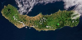
Machico is a municipality, parish and city in the southeast part of the island of Madeira, in the Autonomous Region of Madeira. The easternmost municipality on the island, it is also the third-most populous area with a population of 21,828 in 2011. The town, proper, had a population of 10,894 in 2001.

Água de Pena is a civil parish in the municipality of Machico on the south-east coast of the Portuguese island of Madeira. The population in 2011 was 2,434, in an area of 5.15 km².

Caniçal is a civil parish in the municipality of Machico in the Portuguese island of Madeira. The population in 2011 was 3,924, in an area of 11.85 km2. Equidistant from Funchal and Santana (20 km), the community is connected to these centres by the Regional 109 roadway. Caniçal is now the principal cargo port in Madeira. Living in this parish is a 109 year old man as of March 7, 2021.
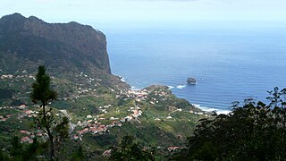
Porto da Cruz ([ˈpoɾtu dɐ ˈkɾuʃ], is a civil parish in the municipality of Machico in the northeastern corner of Madeira. The population in 2011 was 2,597, in an area of 25.22 km².
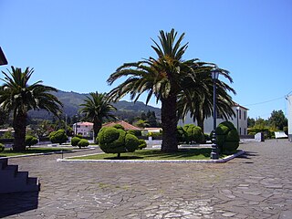
Santo António da Serra is a civil parish in the interior of the municipality of Machico, on the island of Madeira. The parish is adjacent to another parish in the neighbouring municipality of Santa Cruz to the south, which is also named Santo António da Serra. The population in 2011 was 1,617, in an area of 8.62 km².
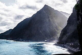
São Vicente is a municipality along the north-west coast of the island of Madeira.

Campanário is a civil parish in the municipality of Ribeira Brava in the Portuguese island of Madeira. The population in 2011 was 4,582, in an area of 11.74 km².

The history of Madeira begins with the discovery of the islands by Portugal in 1419. There is no record of anyone living on the islands at that time. Portugal began populating the island in 1420.

Associação Desportiva de Machico, or simply Machico is a sports club based in the city of Machico, on the Portuguese island of Madeira.
Furna de Água is a cave system located in the municipality of Angra do Heroísmo, on the island of Terceira in the Portuguese archipelago of the Azores. The 560 metres (1,840 ft) long volcanic lava tube, is one of the main sources of fresh water on the island, due to the presence of several springs within the cave. Although known since 1838, Furna de Água only began to be prospected and used in the mid-20th century.

The Azores Geopark is a network of 121 geographically-dispersed sites of geographic heritage and marine areas that covers the nine volcanic islands of the archipelago of the Azores. This network is managed by the Azores Geopark Association, a non-profit association, with its headquarters in Horta on the island of Faial, established 19 May 2010. It is part of the European Geoparks Network and the UNESCO Global Geoparks Network. The Association's mission is to ensure the geological conservation, environmental education and sustainable development, while promoting the well-being of the population and a respect for the environment.
On the island of Madeira, a large number of different sports are practiced, both outdoor and indoor the various facilities available throughout the island.

The São Vicente Caves are caves located in the parish and county of São Vicente, Madeira. Entrance is charged at €8 for adults, but have been closed since March 2020.

