Gabas, Pyrénées-Atlantiques

Last updated
The hamlet of Gabas Gabas 005.jpg
The hamlet of Gabas

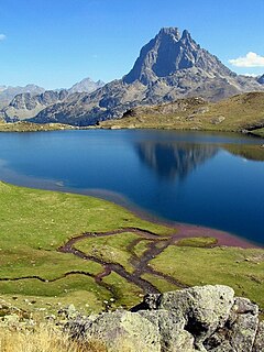
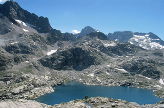
Gabas is a hamlet in the valley of the Gave d'Ossau in the French Pyrenees. It is located where that river is formed by the confluence of two mountain streams, the Gave de Bious and the Gave du Brousset, which flow respectively from the western and eastern sides of the Pic du Midi d'Ossau. [1]

Hamlet (place) small settlement in a rural area

A hamlet is a small human settlement. In different jurisdictions and geographies, hamlets may be the size of a town, village or parish, be considered a smaller settlement or subdivision or satellite entity to a larger settlement. The word and concept of a hamlet have roots in the Anglo-Norman settlement of England, where the old French hamlet came to apply to small human settlements. In British geography, a hamlet is considered smaller than a village and distinctly without a church.

Gave dOssau river

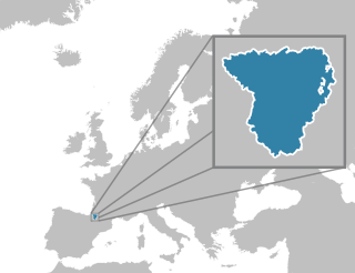
The Gave d'Ossau is the torrential river flowing through the Ossau Valley, one of the three main valleys of the High-Béarn (Pyrénées-Atlantiques), in the Southwest of France.

France Republic with mainland in Europe and numerous oversea territories

France, officially the French Republic, is a country whose territory consists of metropolitan France in Western Europe and several overseas regions and territories. The metropolitan area of France extends from the Mediterranean Sea to the English Channel and the North Sea, and from the Rhine to the Atlantic Ocean. It is bordered by Belgium, Luxembourg and Germany to the northeast, Switzerland and Italy to the east, and Andorra and Spain to the south. The overseas territories include French Guiana in South America and several islands in the Atlantic, Pacific and Indian oceans. The country's 18 integral regions span a combined area of 643,801 square kilometres (248,573 sq mi) and a total population of 67.3 million. France, a sovereign state, is a unitary semi-presidential republic with its capital in Paris, the country's largest city and main cultural and commercial centre. Other major urban areas include Lyon, Marseille, Toulouse, Bordeaux, Lille and Nice.

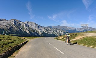
The hamlet is on the D934 road that runs from Pau to Spain, via the Col du Pourtalet, at the point where it is crossed by the GR10 long distance footpath that runs the length of the Pyrenees. Because of this location, Gabas has become a tourist gateway with an importance beyond its size. It is the site of an information centre of the Pyrenees National Park, a mountain ecology centre, a mountain refuge and several hotels. [1]

Pau, Pyrénées-Atlantiques Prefecture and commune in Nouvelle-Aquitaine, France

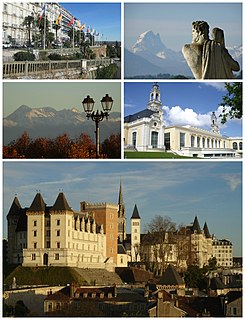
Pau is a commune on the northern edge of the Pyrenees, and capital of the Pyrénées-Atlantiques Département in the region of Nouvelle-Aquitaine, France.

Spain Kingdom in Southwest Europe

Spain, officially the Kingdom of Spain, is a country mostly located in Europe. Its continental European territory is situated on the Iberian Peninsula. Its territory also includes two archipelagoes: the Canary Islands off the coast of Africa, and the Balearic Islands in the Mediterranean Sea. The African enclaves of Ceuta, Melilla, and Peñón de Vélez de la Gomera make Spain the only European country to have a physical border with an African country (Morocco). Several small islands in the Alboran Sea are also part of Spanish territory. The country's mainland is bordered to the south and east by the Mediterranean Sea except for a small land boundary with Gibraltar; to the north and northeast by France, Andorra, and the Bay of Biscay; and to the west and northwest by Portugal and the Atlantic Ocean.

Col du Pourtalet

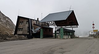
The Col du Pourtalet, El Portalet or Portalet d'Aneu is a mountain pass and border crossing in the Pyrenees, between France and Spain. The pass reaches an elevation of 1,794 m (5,886 ft), and links the Ossau and Tena valleys.

Politically, Gabas forms part of the commune of Laruns in the département of Pyrénées-Atlantiques. The actual village of Laruns is some 13 km (8.1 mi) to the north of Gabas on the D934.

Laruns Commune in Nouvelle-Aquitaine, France

Laruns is a commune in the Pyrénées-Atlantiques department in south-western France.

Pyrénées-Atlantiques Department of France

Pyrénées-Atlantiques is a department in the region of Nouvelle-Aquitaine, in southwestern France. It takes its name from the Pyrenees mountains and the Atlantic Ocean. It covers the French Basque Country and the Béarn.

Related Research Articles

Pyrenees Range of mountains in southwest Europe

The Pyrenees is a range of mountains in southwest Europe that forms a natural border between Spain and France. Reaching a height of 3,404 metres (11,168 ft) altitude at the peak of Aneto, the range separates the Iberian Peninsula from the rest of continental Europe, and extends for about 491 km (305 mi) from the Bay of Biscay to the Mediterranean Sea.

Béarn Place in France

Béarn is one of the traditional provinces of France, located in the Pyrenees mountains and in the plain at their feet, in southwest France. Along with the three Basque provinces of Soule, Lower Navarre, and Labourd, the principality of Bidache, as well as small parts of Gascony, it forms in the southwest the current département of Pyrénées-Atlantiques (64). The capitals of Béarn were Beneharnum, Morlaàs, Orthez, then Pau.

Pic du Midi dOssau mountain

The Pic du Midi d'Ossau is a mountain rising above the Ossau Valley in the French Pyrenees. Despite possessing neither a glacier nor, in the context of the range, a particularly high summit, its distinctive shape makes it a symbol of the French side of the Pyrenees. This familiar shape also makes it easily recognisable from afar, and it is particularly distinctive from the Boulevard des Pyrénées in Pau, some 55 km to the north.

Col dAubisque mountain pass

The Col d'Aubisque is a mountain pass in the Pyrenees 30 km (19 mi) south of Tarbes and Pau in the department of the Pyrénées-Atlantiques, in the Aquitaine region of France.

The French word gave is a generic name referring to torrential rivers, in the west side of the Pyrenees. In the central part of the Pyrenees, the name neste has the same function.

Gourette ski resort

Gourette is a winter sports resort in the French Pyrenees. It is located in the commune of Eaux-Bonnes in the département of Pyrénées-Atlantiques, on the D 918 road which passes through the Col d'Aubisque mountain pass. The closest air access is Pau Pyrénées Airport.

Col de Marie-Blanque mountain pass

Col de Marie-Blanque is a mountain pass in the western Pyrenees in the department of Pyrénées-Atlantiques in France. The pass is situated south-east of Oloron-Sainte-Marie and connects the valleys of the Aspe and the Ossau rivers.

Aste-Béon Commune in Nouvelle-Aquitaine, France

Aste-Béon is a commune in the Pyrénées-Atlantiques department in the Nouvelle-Aquitaine region of south-western France.

Asasp-Arros Commune in Nouvelle-Aquitaine, France

Asasp-Arros is a commune in the Pyrénées-Atlantiques department in the Nouvelle-Aquitaine region of south-western France.

Arudy Commune in Nouvelle-Aquitaine, France

Arudy is a commune in the Pyrénées-Atlantiques department in the Nouvelle-Aquitaine region of south-western France.

Goust Hamlet in Aquitaine, France

Goust is a hamlet in the Pyrénées-Atlantiques department of southwestern France. At some point in the 19th century, folklore began to describe it as an independent Republic. Noted for its centenarians, one pensioner was reported to have reached the age of 123, although this is unconfirmed.

Lys, Pyrénées-Atlantiques Commune in Nouvelle-Aquitaine, France

Lys is a commune in the Pyrénées-Atlantiques department in southwestern France.

Eaux-Chaudes human settlement in France

Eaux-Chaudes is a spa in the valley of the Gave d'Ossau in the French Pyrenees.

Boulevard des Pyrénées thoroughfare in Pau, France

The Boulevard des Pyrénées is a boulevard in the town of Pau in the Pyrénées-Atlantiques département of south-west France. With buildings on its northern side only, and a terrace overlooking the valley of the Gave de Pau to its south, the boulevard is notable for its panoramic view of the peaks of the Pyrenees some 50 km to the south.

Petit train dArtouste

The Petit train d'Artouste is a narrow gauge tourist railway situated in the French Pyrenees close to the Spanish border, some 55 km (34.2 mi) south of the town of Pau, and within the commune of Laruns. The line runs high above the headwaters of the Gave d'Ossau, and provides access to the Lac d'Artouste, a semi-artificial lake in the mountains at an altitude of over 2,000 m (6,562 ft).

The canton of Laruns is a former canton located in the arrondissement of Oloron-Sainte-Marie, in the département of Pyrénées-Atlantiques, in the Aquitaine région of France. It was disbanded following the French canton reorganisation which came into effect in March 2015. It consisted of 8 communes, which joined the canton of Oloron-Sainte-Marie-2 in 2015.

Ossau Valley

The Ossau Valley is a valley of the French Pyrénées, in the Pyrénées-Atlantiques département.

References

  1. 1 2 Reynolds, Kev (2004). The Pyrenees: The High Pyrenees from the Cirque De Lescun to the Carlit Massif. Cicerone Press. p. 135. ISBN   1-85284-420-5.


Coordinates: 42°53′23″N0°25′40″W / 42.889764°N 0.427858°W / 42.889764; -0.427858

Geographic coordinate system Coordinate system

A geographic coordinate system is a coordinate system that enables every location on Earth to be specified by a set of numbers, letters or symbols. The coordinates are often chosen such that one of the numbers represents a vertical position and two or three of the numbers represent a horizontal position; alternatively, a geographic position may be expressed in a combined three-dimensional Cartesian vector. A common choice of coordinates is latitude, longitude and elevation. To specify a location on a plane requires a map projection.