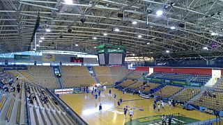
Zlatorog Arena is an indoor sporting arena located in Celje, Slovenia which opened in December 2003. The arena has 5,191 seats, depending on the seating configuration, and also a standing area for approximately 500 people. It hosts the home games of RK Celje team handball club. Zlatorog Arena hosted the Group C of preliminary round at the EuroBasket 2013.
The Roman Catholic Diocese of Celje is a diocese located in the city of Celje in the Ecclesiastical province of Maribor in Slovenia.
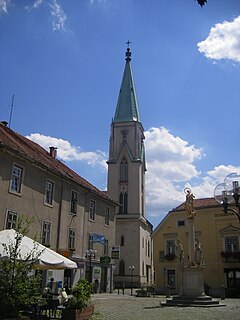
Center is a district and the central neighborhood of the city of Celje in central-eastern Slovenia.
Dečkovo Naselje is a district and a neighborhood of the city of Celje in Slovenia.

Dolgo Polje is a district of the City Municipality of Celje and a neighborhood of the city of Celje in central-eastern Slovenia.
Hudinja is a district along the Hudinja in the northern part of Celje, Slovenia. Hudinja consists of two informal parts: Spodnja Hudinja and Zgornja Hudinja. It is named after the Hudinja River, a tributary of the Savinja, which flows through it. Zgornja Hudinja was an independent settlement until 1982.
Karel Destovnik Kajuh is a district of the City Municipality of Celje and a neighborhood of the city of Celje in Slovenia. It was named after the Slovene Partisan hero Karel Destovnik, a.k.a. Kajuh.

Lava is a district of the City Municipality of Celje and a locality in the northwestern part of the city of Celje. Until 1982, Lava was an independent settlement.

Nova Vas is a district of the City Municipality of Celje and a neighborhood of the city of Celje in Slovenia.
Savinja is a district of the City Municipality of Celje and a neighborhood of the city of Celje in Slovenia. It is named after the Savinja River.
Slavko Šlander is a district of the City Municipality of Celje and a neighborhood of the city of Celje in Slovenia. It was named after the Slovene Partisan hero Slavko Šlander.
Ostrožno is a local community of the City Municipality of Celje in central-eastern Slovenia. Until 1982, Ostrožno was an independent settlement.

The Celje Water Tower is a well-preserved part of the town walls of Celje, Slovenia. It was built as a corner tower after 1451 and redesigned in the 16th century. Since 2010, it has been protected as a cultural monument of local significance.

Novo Celje is a late Baroque mansion in the settlement of Novo Celje in the Municipality of Žalec west of Celje in the Styria region of Slovenia.
The People's Savings Bank also known as Celje Bank is a bank in the town of Celje in Slovenia. It was founded in 1895 by the Catholic middle class. It has branches in Celje and Ljubljana. Its building was designed by Slovene architect Jože Plečnik and was built between 1928 and 1929.
Celje National Hall is a city hall in Celje, a town in central-eastern Slovenia. It was built between 1895 and 1896 and today hosts the seat of a township. It was designed by the Czech architects Jan Vladimír Hráský and Jan Vejrych and was a multimodal building. Such national halls were typical of the Slovene Lands of the period.

The Celje Post Office is the administrative post office in the city of Celje, Slovenia. Celje used the post number 63000 between 1945-1991. Since 1991, when Slovenia became independent, it uses the number SI-3000.
Gaberje is a Slovene place name that may refer to:
Krzesin-Parcel is a settlement in the administrative district of Gmina Kutno, within Kutno County, Łódź Voivodeship, in central Poland.

The Sava Hills are the eastern part of the Slovene Prealps. They are oriented in the east-west direction and are located to the north and south of the Sava River in central and eastern Slovenia, among the Ljubljana Basin to the west, the Celje Basin to the north, the Lower Carniola valley system and the Krško Basin to the south, and the Sotla Hills to the east. They cover an area of 1,909 square kilometres (737 sq mi) and are the largest Slovenian mesoregion.