Hudinja (district)

Last updated

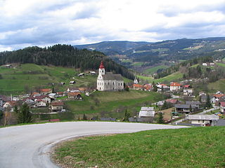
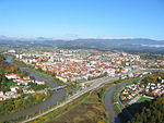
Hudinja (pronounced  [xuˈdiːnja] ) is a district (mestna četrt) along the Hudinja in the northern part of Celje, Slovenia. Hudinja consists of two informal parts: Spodnja Hudinja (literally, 'Lower Hudinja') and Zgornja Hudinja (literally, 'Upper Hudinja'). It is named after the Hudinja River, a tributary of the Savinja, which flows through it. Zgornja Hudinja was an independent settlement until 1982. [1]

Hudinja (river) river in Slovenia

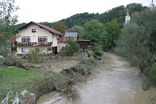
The Hudinja is a river in Styria, Slovenia. The river is 32 kilometres (20 mi) in length. Its source is on the Pohorje Massif southwest of Mount Rogla, about 1380 m above sea level, near the source of Dravinja River. The river passes Vitanje, Socka Castle, Vojnik, and Celje, where it flows into the Voglajna. A district of Celje also named Hudinja lies on the river.

Celje Place in Slovenia

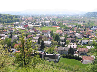
Celje is the third-largest town in Slovenia. It is a regional center of the traditional Slovenian region of Styria and the administrative seat of the City Municipality of Celje. The town of Celje is located below Upper Celje Castle at the confluence of the Savinja, Hudinja, Ložnica, and Voglajna rivers in the lower Savinja Valley, and at the crossing of the roads connecting Ljubljana, Maribor, Velenje, and the Central Sava Valley. It lies 238 m (781 ft) above mean sea level (MSL).

Slovenia republic in Central Europe

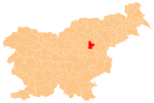
Slovenia, officially the Republic of Slovenia, is a sovereign state located in southern Central Europe at a crossroads of important European cultural and trade routes. It is bordered by Italy to the west, Austria to the north, Hungary to the northeast, Croatia to the southeast, and the Adriatic Sea to the southwest. It covers 20,273 square kilometers (7,827 sq mi) and has a population of 2.07 million. One of the successor states of the former Yugoslavia, Slovenia is a parliamentary republic and a member of the United Nations, of the European Union, and of NATO. The capital and largest city is Ljubljana.

A modern sports center was recently built in Hudinja. The main buildings are the Arena Petrol football stadium (built between 1999 and 2003) and the Zlatorog Arena.

Soccer-specific stadium

Soccer-specific stadium is a term used mainly in the United States and Canada to refer to a sports stadium either purpose-built or fundamentally redesigned for soccer and whose primary function is to host soccer matches, as opposed to a multipurpose stadium which is for a variety of sports. A soccer-specific stadium may host other sporting events and concerts, but the design and purpose of a soccer-specific stadium is primarily for soccer. Some facilities have a permanent stage at one end of the stadium used for staging concerts.

Zlatorog Arena

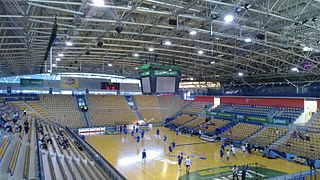
Zlatorog Arena is an indoor sporting arena located in Celje, Slovenia which opened in December 2003. The arena has 5,191 seats, depending on the seating configuration, and also a standing area for approximately 500 people. It hosts the home games of RK Celje team handball club. Zlatorog Arena hosted the Group C of preliminary round at the EuroBasket 2013.

Related Research Articles

Savinja river in Slovenia

The Savinja is a river in northeast Slovenia which flows mostly in the Upper and Lower Savinja Valley and through the cities of Celje and Laško. The Savinja is the main river of the Savinja Alps. It flows into the Sava River at the town of Zidani Most. It has often flooded, such as in the 1960s, 1990, and 1995. The Savinja has a length of 101.75 kilometres (63.22 mi) and a catchment area of 1,847.7 km2 (713.4 sq mi).

Vitanje Town and Municipality in Slovenia

Vitanje is a small town and a municipality in northeastern Slovenia. It lies on the Hudinja River north of Celje. Traditionally the area was part of the Styria region. The municipality is now included in the Savinja Statistical Region. From the 11th century onwards it became a regional centre and was granted market rights in 1306.

Vojnik, Vojnik Place in Styria, Slovenia

Vojnik is the largest settlement and the centre of the Municipality of Vojnik in eastern Slovenia. It lies on the Hudinja River, north of Celje. Traditionally the area was part of the Lower Styria region. The municipality is now included in the Savinja Statistical Region.

Lava (district)

Lava is a district of the City Municipality of Celje and a locality in the northwestern part of the city of Celje. Until 1982, Lava was an independent settlement.

Škofja Vas Place in Styria, Slovenia

Škofja Vas is a settlement in the City Municipality of Celje in eastern Slovenia. It lies on the Hudinja River in the northern outskirts of Celje. The area was traditionally part of the Styria region. It is now included with the rest of the municipality in the Savinja Statistical Region.

Celje Water Tower fortified tower in Celje, Slovenia

The Celje Water Tower is a well-preserved part of the town walls of Celje, Slovenia. It was built as a corner tower after 1451 and redesigned in the 16th century. Since 2010, it has been protected as a cultural monument of local significance.

Novo Celje Mansion

Novo Celje is a late Baroque mansion in the settlement of Novo Celje in the Municipality of Žalec west of Celje in the Styria region of Slovenia.

Peoples Savings Bank (Celje)

The People's Savings Bank also known as Celje Bank is a bank in the town of Celje in Slovenia. It was founded in 1895 by the Catholic middle class. It has branches in Celje and Ljubljana. Its building was designed by Slovene architect Jože Plečnik and was built between 1928 and 1929.

Celje National Hall

Celje National Hall is a city hall in Celje, a town in central-eastern Slovenia. It was built between 1895 and 1896 and today hosts the seat of a township. It was designed by the Czech architects Jan Vladimír Hráský and Jan Vejrych and was a multimodal building. Such national halls were typical of the Slovene Lands of the period.

Celje Post Office

The Celje Post Office is the administrative post office in the city of Celje, Slovenia. Celje used the post number 63000 between 1945-1991. Since 1991, when Slovenia became independent, it uses the number SI-3000.

Šmarjeta pri Celju Place in Styria, Slovenia

Šmarjeta pri Celju is a settlement in the City Municipality of Celje in eastern Slovenia. It lies on the Hudinja River in the northern outskirts of Celje. The area was traditionally part of the Styria region. It is now included with the rest of the municipality in the Savinja Statistical Region.

Dobrova, Celje Place in Styria, Slovenia

Dobrova is a settlement in the City Municipality of Celje in eastern Slovenia. It lies on the northern outskirts of the town of Celje. The area was traditionally part of the Styria region. It is now included in the Savinja Statistical Region.

Zgornja Lipnica Place in Upper Carniola, Slovenia

Zgornja Lipnica is a settlement in the Municipality of Radovljica in the Upper Carniola region of Slovenia.

Nova Cerkev Place in Styria, Slovenia

Nova Cerkev is a settlement in the Municipality of Vojnik in eastern Slovenia. It lies on the left bank of the Hudinja River northwest of Vojnik off the main road to Velenje. The area was traditionally part of the Styria region. It is now included with the rest of the municipality in the Savinja Statistical Region.

Galicija, Žalec in Styria, Slovenia

Galicija is a settlement in the Municipality of Žalec in east-central Slovenia. It lies in the Hudinja Hills north of Žalec. The area is part of the traditional region of Styria. The municipality is now included in the Savinja Statistical Region.

Mass graves in Celje were created in Celje, Slovenia, after the Second World War, from 1945 to 1956. The 11 known mass graves in Celje itself and 14 in the immediate vicinity include some of the largest mass graves in Slovenia.

Zgornja Zadobrova Place in Upper Carniola, Slovenia

Zgornja Zadobrova is a formerly independent settlement in the eastern part of the capital Ljubljana in central Slovenia. It was part of the traditional region of Upper Carniola and is now included with the rest of the municipality in the Central Slovenia Statistical Region.

References

  1. "Celje". Place Names (in Slovenian). Statistical Office of the Republic of Slovenia. Retrieved 23 June 2015.

Coordinates: 46°14′55.26″N15°16′34.05″E / 46.2486833°N 15.2761250°E / 46.2486833; 15.2761250

Geographic coordinate system Coordinate system

A geographic coordinate system is a coordinate system that enables every location on Earth to be specified by a set of numbers, letters or symbols. The coordinates are often chosen such that one of the numbers represents a vertical position and two or three of the numbers represent a horizontal position; alternatively, a geographic position may be expressed in a combined three-dimensional Cartesian vector. A common choice of coordinates is latitude, longitude and elevation. To specify a location on a plane requires a map projection.