Related Research Articles
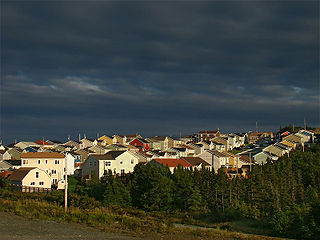
Paradise is a town on the Avalon Peninsula in the province of Newfoundland and Labrador, Canada. The town is a part of the St. John's Metropolitan Area and borders the City of St. John's, the City of Mount Pearl, the Town of Portugal Cove-St. Philip's, and the town of Conception Bay South. According to the 2016 Canadian census the population of Paradise is 21,389, after recording a 21% increase in population over five years.
Division No. 1, Subdivision A is an unorganized subdivision on the Avalon Peninsula in Newfoundland and Labrador, Canada. It is in Division No. 1, and lies between Trinity Bay and Placentia Bay.

Badger is a town in north-central Newfoundland, Newfoundland and Labrador, Canada on the Exploits River. It supplied pulp and paper for the mills in Grand Falls for many years and was famous for its large spring log drives. The town is located in the interior of the island, twenty miles west of Grand Falls in Division No. 6. Badger was incorporated as a Town on September 30, 1963.

Deer Lake is a town in the western part of the island of Newfoundland in the province of Newfoundland and Labrador, Canada.

The Newfoundland Railway operated on the island of Newfoundland from 1898 to 1988. With a total track length of 906 miles (1,458 km), it was the longest 3 ft 6 in narrow-gauge railway system in North America.

Lewisporte is a town in central Newfoundland, Canada, with a population of 3,409. It is situated in Burnt Bay which opens on to the Bay of Exploits. Lewisporte has a deep water port and related facilities that serve many communities in the region.

Conception Bay South is a town located on the southern shore of Conception Bay on the Avalon Peninsula of the island of Newfoundland, Province of Newfoundland and Labrador, Canada. The town is commonly called C.B.S.
Quarry is an abandoned railway community that was located in the Gaff Topsails area of the province of Newfoundland, Canada. The community lies just north of Buchans and takes its name from the quarry established in the 1890s when the Newfoundland Railway was being built.

The Great Northern Peninsula is the largest and longest peninsula of Newfoundland, Canada, approximately 270 km long and 90 km wide at its widest point and encompassing an area of 17,483 km2. It is defined as that part of Newfoundland from Bonne Bay northwards around Cape Norman and Cape Bauld and thence southwards to the head of White Bay, bounded by the Gulf of St. Lawrence on the west, the Strait of Belle Isle on the north and the Labrador Sea and White Bay on the east.
Buchans is a town located in the central part of the island of Newfoundland in the province of Newfoundland and Labrador. It is situated on the northwest shore of Red Indian Lake on the Buchans River.
Baie Verte is a town located on the north coast of the island portion of the Canadian province of Newfoundland and Labrador on the Baie Verte Peninsula.
Garia was a small town located in Garia Bay on the south coast of Newfoundland and Labrador. The origin of the town's name is probably from the French word 'gare'. The first record of the existence of this community was in 1765 when James Cook recorded one fishing stage in the area. The first record of permanent inhabitants was in the 1836 census when 12 inhabitants were living in the town. The population peaked in 1869 at 195. In 1873 approximately three quarters of the population left for work on Anticosti Island leaving only 55 inhabitants by 1874. The population continued to decline until the community was abandoned sometime after 1911.
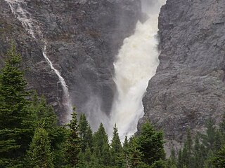
Rattling Brook is a small inlet coastal village located in North Central Newfoundland, close to Baie Verte, Springdale and other coastal towns nearby. Formerly a fishing village, its main residents are retirees and seasonal tourists. The town has a park at the base of Rattling Brook Falls, a 140-meter waterfall beneath a natural rock formation.
Little Bay is a town located in the Canadian province of Newfoundland and Labrador. Its current population is about 166 people. It is located in Green Bay, which is part of Notre Dame Bay, which is located in the central part of Newfoundland and Labrador. Some towns near Little Bay include Beachside, St Patrick's, Little Bay Islands, and the main center for Green Bay, Springdale.
Millertown is a town in the Canadian province of Newfoundland and Labrador on the north-east side of Red Indian Lake. The town had a population of 81 in the Canada 2016 Census.

South Brook is a town in the Canadian province of Newfoundland and Labrador. It is located in the center region of the island of Newfoundland. The town had a population of 482 in 2016, down from 531 in the Canada 2006 Census.
Westport is a town in the Canadian province of Newfoundland and Labrador. The town had a population of 195 in 2016, down from 220 in the Canada 2011 Census.

Millertown Junction is a settlement on the island of Newfoundland in the Canadian Province of Newfoundland and Labrador. It is located at the northeast end of the small lake called Joe Glodes Pond, about where the original railway settlement was though summer cabins have spread in recent years down the eastern fringe of the lake, and a short distance to the west. Millertown Junction was last officially reported in the census in 1981 when it returned a population of 23, the latest in a series of dramatic falls connected with the closing of the railway. Recent years have seen an increase in population, however.
Buchans Junction is a community located in the central part of the island of Newfoundland in the province of Newfoundland and Labrador. It is situated on the banks of Mary March River near where the Mary March River flows into the northeast end of Red Indian Lake. The community is on a site first known as "Four Mile Siding" on the railway which was constructed in 1900 to connect the community of Millertown to the Newfoundland Railway at Millertown Junction. The site itself became a rail junction in 1927 when Asarco subsidiary, the Buchans Mining Company, completed a rail link from the newly formed mining town of Buchans. Ever since 1927, even after the Buchans Railway closed in 1977, the community has been known as "Buchans Junction."
Route 371, also known as Millertown Junction Road, is a 19.9-kilometre-long (12.4 mi) north–south highway in central Newfoundland in the Canadian province of Newfoundland and Labrador. It is an entirely unsigned, narrow, gravel road for its entire length, serving as the only access road to the community of Millertown Junction, connecting with Route 370 at the other end. It is believed by some that this road has been abandoned, even though this is clearly not the case. There are no other major intersections or communities along the entire length of Route 371.