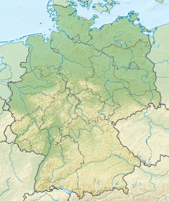
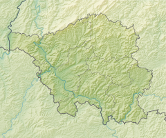
The Saarland is a state of Germany in the west of the country. With an area of 2,570 km2 (990 sq mi) and population of 995,600 in 2015, it is the smallest German state in area apart from the city-states of Berlin, Bremen, and Hamburg, and the smallest in population apart from Bremen. Saarbrücken is the state capital and largest city; other cities include Neunkirchen and Saarlouis. Saarland is mainly surrounded by the department of Moselle in France to the west and south and the neighboring state of Rhineland-Palatinate in Germany to the north and east; it also shares a small border about 8 kilometres long with the canton of Remich in Luxembourg to the northwest.

Saarbrücken is the capital and largest city of the state of Saarland, Germany. Saarbrücken is Saarland's administrative, commercial and cultural centre and is next to the French border.

Saarlouis is a town in Saarland, Germany, capital of the district of Saarlouis. In 2017, the town had a population of 34,758. Saarlouis, as the name implies, is located on the river Saar. It was built as a fortress in 1680 and was named after Louis XIV of France.

The Saarland national football team was the association football team representing the Saar Protectorate in international football from 1950 to 1956 during the French occupation following World War II. As France opposed the inclusion of the Saarland in the Federal Republic of Germany until 1956, they administered it separately from Germany as the Saar Protectorate.
The Saar Protectorate officially Saarland was a French protectorate partitioned from Germany after its defeat in World War II. It was administered by the French Fourth Republic. On rejoining the Federal Republic of Germany in 1957, it became the smallest "federal state" (Bundesland), the Saarland, not counting the "city states" of West Berlin, Hamburg, and Bremen. It is named after the Saar River.
Überherrn is a municipality in the district of Saarlouis, in Saarland, Germany. It is situated along the river Bist on the border with France, approx. 10 km (6.21 mi) southwest of Saarlouis, and 20 km (12.43 mi) west of Saarbrücken. It has 12,150 inhabitants. At the part Felsberg-Berus, there is the Longwave transmitter Europe 1.

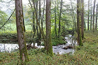
The Blies is a right tributary of the Saar in southwestern Germany (Saarland) and northeastern France (Moselle). The Blies flows from three springs in the Hunsrück near Selbach, Germany. It is roughly 100 km long, ending in the French city of Sarreguemines. It flows through Sankt Wendel, Ottweiler, Neunkirchen, Bexbach, Homburg and Blieskastel. Its lower extent demarcates part of the Franco–German border. The section within France and on the French-German border is 19.7 km (12.2 mi) long.

Saarländischer Rundfunk is a public radio and television broadcaster serving the German state of Saarland. With headquarters in the Halberg Broadcasting House in Saarbrücken, SR is a member of the ARD consortium of German public-broadcasting organizations.

The Glan is a river in southwestern Germany, right tributary of the Nahe. It is approximately 68 km long. It rises in the Saarland, northwest of Homburg. It flows generally north, through Rhineland-Palatinate, and empties into the Nahe near Odernheim am Glan, at Staudernheim, across the Nahe from Bad Sobernheim. Other towns along the Glan are Altenglan, Glan-Münchweiler, Lauterecken and Meisenheim.

Bous is a municipality in the district of Saarlouis, in Saarland, Germany. It is situated on the river Saar, approx. 5 km southeast of Saarlouis, and 15 km west of Saarbrücken.
Völklingen is a town in the district of Saarbrücken, in Saarland, Germany. It is situated on the river Saar, approx. 10 km west of Saarbrücken, and directly borders France.

Kleinblittersdorf is a village and a municipality in the district of Saarbrücken, in Saarland, Germany. It is situated on the river Saar, opposite Grosbliederstroff in France, approx. 10 km south of Saarbrücken.

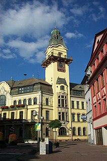
Bexbach is a town in the Saarpfalz district, in Saarland, Germany. It is situated on the river Blies, approximatively 6 km east of Neunkirchen, and 25 km northeast of Saarbrücken. The Saarländisches Bergbaumuseum is located in the town.
The Nied is a river in Lorraine, France, and Saarland, Germany. It is a left tributary of the Saar. It is formed where two streams converge: the Nied allemande and the Nied française, which join in Condé-Northen.
The Bist is a river in France and in Germany, and a 26.3-kilometre-long (16.3 mi) left tributary of the Saar. It is 26.3 km (16.3 mi) long, of which 15.8 km (9.8 mi) within France and on the French-German border.
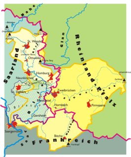
The Bliesgau is a region in the state of Saarland in the south-west of Germany and borders with France. It is named after the River Blies, which is a tributary to the Saar.
Bickenalb is a river of Moselle, France and Saarland, Germany. It flows into the Horn near Zweibrücken. Its course within France is 10.3 km (6.4 mi) long.

Rossel is a river flowing on the border of the department of Moselle (France) and Saarland (Germany). It rises in Longeville-les-Saint-Avold near the border of France and Germany and flows northwards into the Saar near Völklingen. Its course within France and on the French-German border is 32.8 km (20.4 mi) long.