Kayunga District is a district in Central Uganda. It is named after its chief town, Kayunga.

Mukono is one of the districts in the Central Region of Uganda. The town of Mukono is home to the district's main commercial center and district headquarters.
Kayunga is a town in the Central Region of Uganda. It is the main municipal, administrative, and commercial center of Kayunga District.
Amolatar District is a district in Northern Uganda. Like many other Ugandan districts, it is named after its main municipal and administrative centre, Amolatar Town.
The Kampala–Jinja Highway is a road in Uganda, connecting the cities of Kampala and Jinja. Sometimes referred to as Kampala–Jinja Road, it is a busy road, with several towns, trading centers and other points of interest along the way. As of October 2016, a new, wider, four-lane dual carriageway expressway, the Kampala–Jinja Expressway, is proposed to be constructed south of the present highway to relieve traffic and complement existing transport infrastructure between Kampala and Jinja.

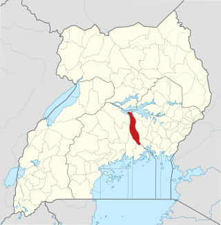
The Sezibwa River is a river in Central Uganda, in East Africa. The name is derived from the Luganda phrase "sizibwa kkubo", which translates into "my path cannot be blocked".
Gombe, is a small town in Wakiso District in the Central Region of Uganda.
Nsangi is a town in the Central Region of Uganda. It is one of the urban centers in Wakiso District.

Kajjansi is a town in Central Uganda. It is one of the urban centers in Wakiso District.
Nakifuma is a town in the Central Region of Uganda.
Bbaale is a town in the Kayunga District in Uganda. It is the location of the headquarters of Bbaale County. The correct phonetic spelling is with two "b"s and two "a"s, although literature exists in which it is spelled Bale.

Buyende District is a district in Eastern Uganda. It is named after Buyende, the 'chief town' in the district and the location of the district headquarters.
Kole is a town in Northern Uganda. It is the main municipal, administrative and commercial center of Kole District. The district is named after the town.
Nazigo is a town in Kayunga District in the Central Region of Uganda.
River Lwajjali is a river in Uganda, in East Africa.
Kayunga–Galiraya Road is a road in the Central Region of Uganda connecting the town of Kayunga to the towns of Bbaale and Galilaya (Galiraya) on the shores of Lake Kyoga.
Karuma is a settlement in the Western Region of Uganda.
Mbalwa is a neighborhood in Kyaliwajjala Parish, Kira Municipality, Wakiso District in the Central Region of Uganda.
Kijabijo is a neighborhood in Kira Town, in Wakiso District in the Buganda Region of Uganda.
Nagojje is a town in the Buganda Region of Uganda. It is a municipality in Mukono District.

