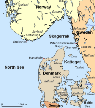
The Kattegat is a 30,000 km2 (12,000 sq mi) sea area bounded by the Jutlandic peninsula in the west, the Danish Straits islands of Denmark and the Baltic Sea to the south and the provinces of Bohuslän, Västergötland, Halland and Skåne in Sweden in the east. The Baltic Sea drains into the Kattegat through the Danish Straits. The sea area is a continuation of the Skagerrak and may be seen as a bay of the North Sea, but in traditional Scandinavian usage, this is not the case.

Västergötland, also known as West Gothland or the Latinized version Westrogothia in older literature, is one of the 25 traditional non-administrative provinces of Sweden, situated in the southwest of Sweden.
Hisingen is the fifth-largest island of Sweden, with an area of 199 km2 (77 sq mi). It is a river island, formed by the split of the Göta Älv at Bohus, and is defined to the east and south by the main arm of that river, to the north by the smaller arm, and to the west by the Kattegat. The southern part of Hisingen is extensively urbanised, representing the northern suburbs of the city of Gothenburg. The island is divided between the historical provinces of Västergötland and Bohuslän, but lies entirely within the modern county of Västra Götaland.
The Skagerrak is a strait running between the Jutland peninsula of Denmark, the southeast coast of Norway and the west coast of Sweden, connecting the North Sea and the Kattegat sea.
Mölle is a locality situated in Höganäs Municipality, Skåne County, Sweden with 715 inhabitants in 2010.

Svartrå is a former village and parish in Falkenberg Municipality, Sweden with about 200 citizens. It formed a parish until 2006, when the parish merged with Köinge and Okome parishes to form Okome parish. It was a municipality between 1863 and 1951. A brook, Svartån, flows through the area. It is likely to have given name to the village which in turn gave the parish its name. Svartrå was first mentioned in 1461, then spelt Swa[r]teraa. Svart means black, while rå means owner's mark or border.
Ny Varberg was a city founded sometime between 1429 and 1434 about five kilometres north of present-day Varberg, Sweden. It was abandoned around 1612. The city was located at a crossroads where the roads from Småland and Västergötland met the royal road through Halland. To have access to the sea, a canal 700 metres long was built between Kattegat and Himleån. It is unclear who founded the city or why.

Kullaberg is a peninsula and nature reserve of land protruding into the Kattegat in Höganäs Municipality near the town of Mölle in southwest Sweden. The site in the province of Skåne is an area of considerable biodiversity supporting a number of rare species and has been designated as an Important Bird Area (IBA) in Sweden as well as a Special Protection Area (SPA). The terrain is dominated by steep cliffs rising from the sea and rocky outcrops on the ridge above, the highest elevation being Håkull at 188 metres. Ridgetop vegetation includes a mixed hardwood broadleaf forest consisting of birch, beech, oak and pine trees with an understory of hawthorn, juniper, wild honeysuckle and blackthorn. Among the notable rare plants are spring vetchling, Lathyrus sphaericus.

The E1 European long-distance path, or just E1 path, is one of the European long-distance paths designated by the European Ramblers' Association. It has a total length of some 7,000 kilometres (4,300 mi). It begins in Norway at Nordkapp, and crosses the Kattegat between Sweden and Denmark by ferry. It passes through Denmark, Germany, and Switzerland to finish at Scapoli, Italy. This path was extended southwards to Sicily, in Italy in 2018.

Ås Abbey was a Cistercian monastery situated near the present village of Åskloster about 14 km north of Varberg, in Varberg Municipality. It was located near the mouth of the River Viskan into the Kattegat in Halland, formerly part of Denmark but now in Sweden

Balgö is an island and a nature reserve in Kattegat, off Tångaberg in Varberg Municipality, Sweden. Balgö is the largest island in Halland. The nature reserve was established in 1950. Some smaller islands around Balgö are also included in the nature reserve.

Gässlösa is a nature reserve in Varberg Municipality, Sweden. It's situated close to Rolfstorp. The reserve has an area of 34.5 hectares. It was established in 1977.

Skärbäck is a nature reserve in Varberg Municipality, Sweden. It's situated between the lakes Skärsjön, Humsjön and Grytsjön. The reserve has an area of 98 hectares and is dominated by broad-leaved deciduous forest. It was established in 1978.

Getterön Nature Reserve is a nature reserve at Getterön in Varberg Municipality, Sweden. It consists of parts of the peninsula Getterön and an area to the north. It has an area of 350 hectares, of which 235 are land. The reserve was established in 1970.

Western Getterön Nature Reserve is a nature reserve at the westernmost part of Getterön in Varberg Municipality, Sweden. It consists of a peninsula which is popularly known as Stora Gubbanäsan, and the surrounding part of the Kattegat. The nature reserve has an area of 183 hectares, of which 53 are land. It was established in 1974.
Skärte is a nature reserve in Varberg Municipality, Sweden. It has an area of 18.2 hectares. The reserve was established in 2006. The land is privately owned but managed by Halland County Council.

Vendelsöarna is an archipelago and a nature reserve in Varberg Municipality, Sweden, near the border with Kungsbacka Municipality. The reserve consists of the northern part of the main island Vendelsö and the surrounding islands Brattö, Norstön, Kidholmen, and Älmö. There are two other islands in the archipelago, Ustö and Knarrskär, but they are not included in the reserve. The protected area has an area of 563 hectares, of which 128 hectares are land. It was established in 2002.
Fegen is a locality situated in Falkenberg Municipality, Halland County, Sweden, with 235 inhabitants in 2015. The village is located at the south shore of lake Fegen, close to the nature reserve Fegen. The country road 153, from Varberg to Värnamo, goes through the village.
Mölle Golf Club is a golf club located on the Kullen peninsula in Höganäs Municipality, southwestern Sweden. It has hosted the Höganäs Ladies Open on the Ladies European Tour.
