Sciotodale is a census-designated place (CDP) in Scioto County, Ohio, United States. The population was 1,081 at the 2010 census.
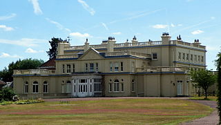
Childwickbury Manor is a manor house in the hamlet of Childwickbury, Hertfordshire, England, between St Albans and Harpenden.
Ford is a hamlet in the parish of Dinton-with-Ford and Upton, in Buckinghamshire, England. It is located in the south eastern corner of the main parish.

Meadle is a hamlet in the civil parish of Longwick-cum-Ilmer, in Buckinghamshire, England. It is located to the north of the village of Monks Risborough and near Little Kimble. The current population of Meadle is about 75. Most of the buildings are very old: farmhouses and labourers' cottages build in traditional red clay brick with thatched roofs. A small stream rises in the village and ultimately joins the Thames.
Milbury Heath is a hamlet in South Gloucestershire, England, located east of Thornbury. The hamlet has a garden centre and a few other farm shops. The heath is a local high point and offers views west across the Severn Vale, and north into the Vale of Berkeley. A seat at the viewpoint commemorates the centenary of Falfield Parish Council in 1994. The hamlet has a former (Methodist?) chapel now converted to a private house, and a duck-pond.

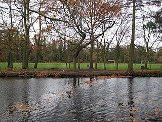
Mile End Park is a park located in the London Borough of Tower Hamlets. It is a linear park of some 32 hectares, and was created on industrial land devastated by World War II bombing. Some of the park is within Limehouse and Globe Town, with the park lying on land to the east of the Regent's Canal. In the north, it is separated from the southern edge of Victoria Park by the Hertford Union Canal. It is open 24 hours a day.
Piddington is a hamlet in the parish of Piddington and Wheeler End in Buckinghamshire, England. It is located on the main A40 between Stokenchurch and West Wycombe.

Balzac is a hamlet in the southern portion of the Canadian province of Alberta, in Rocky View County. It is located immediately west of Queen Elizabeth II Highway, at the intersection with Highway 566, 24 km (15 mi) north of Calgary city centre and 12 km (7.5 mi) south of Airdrie.
Endiang, Alberta is a hamlet in Alberta, Canada within the County of Stettler No. 6. It is located approximately 80 kilometres (50 mi) southeast of Stettler, Alberta.
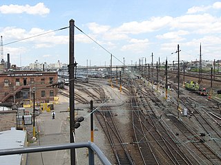
Sunnyside Yard is a large coach yard, a railroad yard for passenger cars, in Sunnyside, Queens in New York City.

The International Bowling Museum is located inside the International Bowling Campus in Arlington, Texas. It reopened there on January 26, 2010, after having been located in St. Louis, Missouri, until November 2008. The design and fabrication of the new facility was awarded to Museum Arts Inc., a Dallas company.

Longborough is a village and civil parish 2.5 miles (4.0 km) north of the market town of Stow on the Wold, Gloucestershire. The parish population taken at the 2011 census was 471.

Girvin is a former village of 20 people in Saskatchewan, Canada. It is located midway between Regina and Saskatoon on Highway 11 between the towns of Davidson and Craik. The village was formally dissolved in 2005; its remaining population is now counted as part of the rural municipality of Arm River.
Valle de Zamanzas is a municipality located in the province of Burgos, Castile and León, Spain. According to the 2004 census (INE), the municipality has a population of 78 inhabitants.
Belair Park is a park located in the West Dulwich part of the London Borough of Southwark, southeast London, England. The park grounds once belonged to Belair House, a country villa built in Adam style that is now a Grade II listed building. There are also two other Grade II listed structures within the park: the lodge and entrance gate, and an old stable building.
Nant-y-derry is a village in the county of Monmouthshire, Wales, located six miles south east of Abergavenny and four miles northwest of Usk.

Altario is a hamlet in east-central Alberta, Canada within Special Area No. 4. It is located on Highway 899 just north of Highway 12, approximately 12 kilometres (7.5 mi) east of Kirriemuir and 14 kilometres (8.7 mi) west of Compeer.

Iniesta is a municipality located in the province of Cuenca, Castile-La Mancha, Spain. According to the 2009 census (INE), the municipality has a population of 4,685 inhabitants.

The Coach and Horses is a Grade II listed public house at 5 Hill Street, Mayfair, London. It dates from the 1740s.

The Coach and Horses is a Grade II listed public house at London Road, Isleworth, London.
