Small hydro is the development of hydroelectric power on a scale suitable for local community and industry, or to contribute to distributed generation in a regional electricity grid. Precise definitions vary, but a "small hydro" project is less than 50 megawatts (MW), and can be further subdivide by scale into "mini" (<1MW), "micro" (<100 kW), "pico" (<10 kW). In contrast many hydroelectric projects are of enormous size, such as the generating plant at the Three Gorges Dam at 22,500 megawatts or the vast multiple projects of the Tennessee Valley Authority.

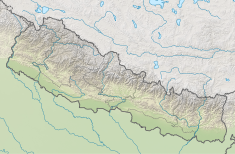
Ghaghara, also called Karnali is a perennial trans-boundary river originating on the Tibetan Plateau near Lake Manasarovar. The Karnali cuts through the Himalayas in Nepal and joins the Sharda River at Brahmaghat in India. Together they form the Ghaghara River, a major left bank tributary of the Ganges. With a length of 507 kilometres (315 mi) it is the longest river in Nepal. The total length of Ghaghara River up to its confluence with the Ganges at Revelganj in Bihar is 1,080 kilometres (670 mi). It is the largest tributary of the Ganges by volume and the second longest tributary of the Ganges by length after Yamuna.

Bhakra Dam is a concrete gravity dam on the Sutlej River in Bilaspur, Himachal Pradesh in northern India. The dam forms the Gobind Sagar reservoir.

The Gandaki River, also known as the Narayani and the Gandak, is one of the major rivers in Nepal and a left bank tributary of the Ganges in India. Its total catchment area amounts to 46,300 km2 (17,900 sq mi), most of it in Nepal. In the Nepal Himalayas, it is notable for its deep canyon. The basin also contains three mountains over 8,000 m (26,000 ft), namely Dhaulagiri, Manaslu and Annapurna I. Dhaulagiri is the highest point of the Gandaki basin.
The Balimela Reservoir is located in Malkangiri district, Odisha, India on the river Sileru which is a tributary of the Godavari river. The gross storage capacity of Balimela reservoir is 3610 million cubic meters.

The Gandhi Sagar Dam is one of the four major dams built on India's Chambal River. The dam is located in the Mandsaur, districts of the state of Madhya Pradesh. It is a masonry gravity dam, standing 62.17 metres (204.0 ft) high, with a gross storage capacity of 7.322 billion cubic metres from a catchment area of 22,584 km2 (8,720 sq mi). The dam's foundation stone was laid by Prime Minister of India Pandit Jawaharlal Nehru on 7 March 1954, and construction of the main dam was done by leading contractor Dwarka Das Agrawal & Associates and was completed in 1960. Additional dam structures were completed downstream in the 1970s.

Nagarjuna Sagar Dam is a masonry dam across the Krishna River at Nagarjuna Sagar which straddles the border between Nalgonda district in Telangana and Guntur district in Andhra Pradesh. The dam provides irrigation water to the Nalgonda, Suryapet, Krishna, Khammam, West Godavari, Guntur, and Prakasam districts along with electricity generation.

The Kosi or Koshi is a trans-boundary river which flows through Tibet, Nepal and India. It drains the northern slopes of the Himalayas in Tibet and the southern slopes in Nepal. From a major confluence of tributaries north of the Chatra Gorge onwards, the Kosi River is also known as Saptakoshi for its seven upper tributaries. These include the Tamor River originating from the Kanchenjunga area in the east and Arun River and Sun Kosi from Tibet. The Sun Koshi's tributaries from east to west are Dudh Koshi, Bhote Koshi, Tamakoshi River, Likhu Khola and Indravati. The Saptakoshi crosses into northern Bihar, India where it branches into distributaries before joining the Ganges near Kursela in Katihar district.

Damodar Valley Corporation (DVC) is an Indian governmental organization which operates in the Damodar River area of West Bengal and Jharkhand states of India. The corporation operates both thermal power stations and hydel power stations under the Ministry of Power, Govt of India. DVC is headquartered in the Kolkata city of West Bengal, India.
The Jawahar Sagar Dam is the third dam in the series of Chambal Valley Projects on the Chambal River, located 29 km upstream of Kota city and 26 km downstream of Rana Pratap Sagar dam. It is a concrete gravity dam, 45 meters high and 393 meters long, generating 60 MW of power with an installed capacity of 3 units of 33 MW. Its construction was completed in 1972. The total catchment area of the dam is 27,195 km2, of which only 1,496 km2 are in Rajasthan. The free catchment area below Rana Pratap Sagar dam is 2,331 km2. The dam is located after the Gandhi Sagar Dam and Rana Pratap Sagar Dam, but before the Kota Barrage.
Bihar is India's most flood-prone state, with 76% population in the North Bihar living under the recurring threat of flood devastation. Bihar makes up 16.5% of India's flood affected area and 22.1% of India's flood affected population. About 73.06% of Bihar's geographical area, ie 68,800 square kilometres (26,600 sq mi) out of 94,160 square kilometres (36,360 sq mi), is flood affected. On an annual basis, they destroy thousands of human lives apart from livestock and assets worth millions. In total, they have claimed 9,500 lives since the government started publishing figures in 1979. North Bihar districts are vulnerable to at least five major flood-causing rivers during monsoon – Mahananda River, Koshi River, Bagmati River, Burhi Gandak River and Gandak – which originate in Nepal. Some south Bihar districts have also become vulnerable to floods from Son, Punpun and Phalgu rivers. The 2013 flood affected over 5.9 million people in 3,768 villages in 20 districts of the state. 2017 flood affected 19 districts of North Bihar killing 514 people. and affecting 1.71 crore people.

The Sharda River, also called Kali River and Mahakali River, originates at Kalapani in the Himalayas at an elevation of 3,600 m (11,800 ft) in the Pithoragarh district in Uttarakhand, India. It flows along Nepal's western border with India and has a basin area of 14,871 km2 (5,742 sq mi). It joins Ghaghra River, a tributary of the Ganges. It takes the name Kali River from the union of the two streams at Gunji as it flows through the hills. After Brahmadev Mandi near Tanakpur, it enters the Terai plains, where it is called Sharda River.

The Polavaram Project is an under construction multi-purpose irrigation project on the Godavari River in the West Godavari District and East Godavari District in Andhra Pradesh. The project has been accorded National project status by the Union Government of India. Its reservoir back water spreads up to the Dummugudem Anicut and approx 115 km on Sabari River side. Thus back water spreads into parts of Chhattisgarh and Odisha States. It gives major boost to tourism sector in Godavari Districts as the reservoir covers the famous Papikonda National Park, Polavaram hydro electric project (HEP) and National Waterway 4 are under construction on left side of the river. It is located 40 km to the upstream of Sir Arthur Cotton Barrage in Rajamahendravaram City and 25 km from Rajahmundry Airport.

Idamalayar Dam is a multipurpose concrete gravity dam located at Ennakkal between Ayyampuzha and Bhoothathankettu in Ernakulam district of Kerala on the Idamalayar, a tributary of the Periyar River in Kerala, South India. The dam however extends east as far as Malakkappara. Completed in 1985, with a length of 373 metres (1,224 ft) and a height of 102.8 metres (337 ft), the dam created a multipurpose reservoir covering 28.3 km2 (10.9 sq mi) in the scenic hills of the Anamalais.

The Kulekhani Dam is a rock-fill dam on the Kulekhani River near Kulekhani in Makwanpur District of Narayani Zone, Nepal. The primary purpose of the dam is hydroelectric power generation and it supports the 60 MW Kulekhani I and 32 MW Kulekhani II Hydropower Stations. Construction began in 1977 and Kulekhani I was commissioned in 1982. Kulekhani II was commissioned in 1986 and a third power station, the 14 MW Kulekhani III was expected to be commissioned in May 2015 but was delayed due to issues with the builder. The US$117.84 million project received funding from the World Bank, Kuwait Fund, UNDP, Overseas Economic Cooperation Fund and OPEC Fund. It is owned by Nepal Electricity Authority.
The Shahpurkandi Dam project is located on the Ravi River in Pathankot district, Punjab, India, downstream from the existing Ranjit Sagar Dam. The power houses will be constructed on Hydel Channel, which is downstream from Shahpurkandi Dam. The water released by Ranjit Sagar Dam is to be utilised for generating power for this project. The project will generate electricity of up to 206MW and provide irrigation to Punjab and Jammu and Kashmir. The construction of the dam is as per the framework of the Indus Water Treaty regarding sharing of rivers between India and Pakistan.
Mahakali Treaty or महाकाली सन्धि is an agreement between the Government of Nepal and the Government of India regarding the development of watershed of Mahakali River. The treaty was signed in 1996. The treaty has 12 articles agreements for an integrated development of barrage, dams and hydropower for mutual cooperation of the two countries by managing the water resources. The treaty recognizes the Mahakali River as a boundary river between the two countries.

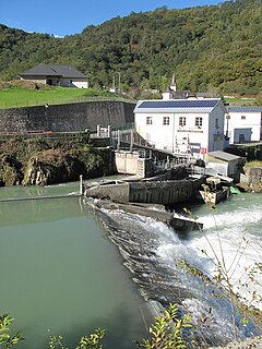
Andhi Khola Hydropower Station is a run-of-river hydro-electric plant located in Syangja District of Nepal. The flow from Andhi River, a tributary of Kali Gandaki River, is used to generate 9.4 MW electricity and annual energy of 68.38 GWh. The plant is owned and developed by Butwal Power Company Limited, an IPP of Nepal in technical help from UMN. The plant started generating electricity since 2052-01-08 BS. The generation licence will expire in 2101-12-30 BS, after which the plant will be handed over to the government. The power station is connected to 132 kV national grid through the substation at Rang Khola and sells electricity to Nepal Electricity Authority.

Middle Marsyandgi Hydropower Station is a run-of-river hydro-electric plant located in Lamjung district of western Nepal. The flow from Marshyangdi River is used to generate 70 MW electricity. The plant is connected to the national grid of Nepal.
Kabeli B1 Hydropower Station is a 25 MW run-of-river hydro-electric plant located in Panchthar District of Nepal. The promoter and operator, with a 20% share, is Arun Kabeli Power Limited (AKPL), a subsidiary of Arun Valley Group.