
Andhra Pradesh is a state in the south-eastern coastal region of India. It is the seventh-largest state by area covering an area of 162,975 km2 (62,925 sq mi) and tenth-most populous state with 49,386,799 inhabitants. It is bordered by Telangana to the north-west, Chhattisgarh to the north, Odisha to the north-east, Tamil Nadu to the south, Karnataka to the west and the Bay of Bengal to the east. It has the second longest coastline in India after Gujarat, of about 974 km (605 mi). Andhra Pradesh is the first state to be formed on a linguistic basis in India on 1 October 1953. Andhra Pradesh was once a major Buddhist pilgrimage site in India and a Buddhist learning center which can be seen in many sites in the state in the form of ruins, chaityas and stupas Andhra Pradesh is also known as the land of the world-famous diamond Koh-i-Noor and many other global known diamonds due to their presence in its Kollur Mine once. It is also known as the "rice bowl of India" for being a major producer of rice in India. Its official language is Telugu; one of the classical languages of India, the fourth most spoken language in India and the 11th-most spoken language in the world.

East Godavari is a district in the Coastal Andhra region of Andhra Pradesh, India. Its district headquarters is at Kakinada. As of Census 2011, it became the most populous district of the state with a population of 5,151,549. Rajahmundry and Kakinada are the major cities in the district in terms of population.

Coastal Andhra is a region in the state of Andhra Pradesh, India. It was part of Madras State before 1953 and Andhra State from 1953 to 1956. According to the 2011 census, it has an area of 95,442 square kilometres (36,850 sq mi) which is 57.99% of the total state area and a population of 34,193,868 which is 69.20% of Andhra Pradesh state population. This area includes the coastal districts of Andhra Pradesh on the Coromandel Coast between the Eastern Ghats and the Bay of Bengal, from the northern border with Odisha to Pulicat lake in the South.
Rajahmundry, officially known as Rajamahendravaram, is a city in the Indian state of Andhra Pradesh. It is located on the banks of Godavari River in the East Godavari district of the state and is the seventh most populated city in the state. During British rule, the District of Rajahmundry was created in the Madras Presidency in 1823. It was reorganised in 1859 and bifurcated into the Godavari and Krishna districts. Rajahmundry was the headquarters of Godavari District, which was further bifurcated into East Godavari and West Godavari districts in 1925. When the Godavari District was bifurcated, Kakinada became the headquarters of East Godavari and Eluru became the headquarters of West Godavari. It is administered under Rajahmundry revenue division. The city is known for its floriculture, history, culture, agriculture, economy, tourism, and its heritage. It is known as the " Cultural Capital of Andhra Pradesh ".

West Godavari district or Paschima Godavari Jilla is one of the nine districts in the Coastal Andhra region of the Indian state of Andhra Pradesh. The administrative headquarters of the district is situated at Eluru. As of 2011 census of India, the district has an area of 7,742 km2 (2,989 sq mi) and a population of 3,936,966. It is bounded by Krishna district on the west, East Godavari district on the east, Bay of Bengal on the south and the state of Telangana on the north.
Khammam district is a district in the eastern region of the Indian state of Telangana. The city of Khammam is the district headquarters. The district shares boundaries with Suryapet, Mahabubabad, Bhadradri districts and with Andhra pradesh state.

Amalapuram is a town in East Godavari of the Indian state of Andhra Pradesh. It is the mandal and divisional headquarters of Amalapuram mandal and Amalapuram revenue division. The town is situated in the delta of Konaseema.
Peddapuram is a town in the East Godavari District of Andhra Pradesh in South India. The town also forms a part of Godavari Urban Development Authority.

Rampachodavaram is a census town in East Godavari district of the Indian state of Andhra Pradesh. It is located in Rampachodavaram mandal of Rampachodavaram revenue division. Rampachodavaram is known for its dense jungle and waterfalls which can be accessed by road transport only.
Samalkota or Samarlakota (Telugu:సామర్లకోట) is a town in East Godavari district of the Indian state of Andhra Pradesh. The town also forms a part of Godavari Urban Development Authority. Previously, spelled as Chamarlakota (Telugu:చామర్లకోట) as evident from local a Kaifiyat written during mid eighteenth century.

Gollaprolu is a town in East Godavari district of the Indian state of Andhra Pradesh. It is a Municipality in Gollaprolu mandal of Kakinada revenue division Business is the main occupation of this town. The town also forms a part of Godavari Urban Development Authority.
Allavaram is a village in Allavaram Mandal, East Godavari district in the state of Andhra Pradesh in India. It is located in Allavaram mandal of Amalapuram revenue division of the district.
Ambajipet mandal is one of the 59 mandals in East Godavari of the Indian state of Andhra Pradesh.
Jaggampeta is a town in Jaggampeta mandal, located in East Godavari district of the Indian state of Andhra Pradesh. It is located on the banks of river Godavari. A town in which worked under British rule since 17th century, Primarily known as an exporter of Tiles to london from India, and today it still shines between the old and tallest pipeholes that used in the creation of tiles. This town also had an primary role in the Andhra Pradesh politics. This city also named as "Uddandula kota", "The gate of Agency", "The Entrance of Maredumilli forests" and "The Center of East Godavari".
Kakinada (rural) mandal is one of the 59 mandals in East Godavari of the state of Andhra Pradesh, India. It has its headquarters at Kakinada. The mandal is bounded by Samalkota mandal, Pedapudi mandal, Karapa mandal, Kothapalle mandal and waters of Bay of Bengal.

As per the 2011 census of India, Andhra Pradesh has an overall literacy rate of 67.35%, significantly lower than the overall national average of 74.04%. Among the Indian states and union territories, it stands at 32nd position. During the same census, there are a total of 29,859,982 literates: 16,549,514 males and 13,310,468 females. In terms of district-wise literates, East Godavari has the most with 3,348,077 and Vizianagaram has the least with 1,238,388. While, in terms of district-wise literacy rates, West Godavari stands top with 74.32% and Vizianagaram at bottom with 58.89%. The government also implements fee reimbursement scheme for the economically backward sections of the state.

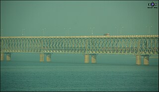
National Highway 216 is a National Highway in the Indian state of Andhra Pradesh. The former highways of NH 214 and 214A were merged and renumbered as NH 216. It starts from NH 16 junction at Kattipudi and passes through Kakinada, Amalapuram, Digamarru (Palakollu), Narasapuram, Machilipatnam, Bapatla, Chirala before it junctions NH 16 again at Ongole. Visakhapatnam–Kakinada Petro Chemical Corridor, is a proposed project along the highway.
Rowthulapudi Mandal is one of the 64 mandals in East Godavari District of Andhra Pradesh. As per census 2011, there are 38 villages.

