
Yeoju is a city in Gyeonggi Province, South Korea. Yeoju was a county but was raised to the status of a city in September 2013. Together with the neighboring city of Icheon, it is known as a major center of contemporary South Korean ceramics, and hosts the World Ceramic Exposition every year. Other local products of note include rice, sweet potatoes, and yellow melons. Yeoju is the birthplace of Korea's last queen, Empress Myeongseong.
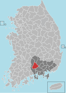
Sancheong County (Sancheong-gun) is a county in South Gyeongsang Province, South Korea.

The Sobaek Mountains are a mountain range cutting across the southern Korean peninsula. They split off from the Taebaek Mountains and trend southwest across the center of the peninsula. They are traditionally considered to reach their southwestern limit at Jirisan, which is also the highest peak of the range. Other famous mountains in the range include Songni Mountain, Joryeong Mountain, Gaya Mountain, Worak Mountain, and Sobaek Mountain itself. The peaks of the Sobaek Mountains are generally well over 1000 m above sea level.
Wonji-dong is a dong, neighbourhood of Seocho-gu in Seoul, South Korea. It is a legal dong administered under its administrative dong, Yangjae 2-dong.
Cheonmasan is a mountain in Gyeonggi-do, South Korea. It can be found within the boundaries of the city of Namyangju. Cheonmasan has an elevation of 810.2 m (2,658 ft).
Bokgyesan is a mountain in the county of Cheorwon, Gangwon-do in South Korea. It has an elevation of 1,054 m (3,458 ft).
Daeyasan is a mountain of South Korea. It has an elevation of 931 metres
Gubyeongsan is a mountain of Chungcheongbuk-do, South Korea. It has an elevation of 876 metres.
Hwangaksan is a mountain of South Korea. It has an elevation of 1,111 metres.
Daedunsan is a mountain of Chungcheongnam-do, western South Korea. It has an elevation of 878 metres. Daedunsan has a thousand stone rods extending for 6 km. Daedun Mountain belongs to the "Old Mountain Range". The vegetation is generally 600m in height, with pine trees, oak trees, korean plum-yem trees and so on. Above that, deciduous broad-leaved trees are dense.
Jangansan is a mountain of Jeollabuk-do, western South Korea. It has an elevation of 1,237 metres.
Jeoksangsan is a mountain of Jeollabuk-do, western South Korea. It has an elevation of 1,034 metres.

Maisan is a mountain of Jeollabuk-do, western South Korea. It has an elevation of 686 metres.
Moaksan is a mountain of Jeollabuk-do, western South Korea. It has an elevation of 793 metres.
Unjangsan is a mountain of Jeollabuk-do, western South Korea. It has an elevation of 1,126 metres.
Jogyesan, or Mount Jogye, is a mountain of South Jeolla Province in southwestern South Korea. It has an elevation of 887 metres (2,910 ft). It is the main attraction of Mount Jogye Provincial Park (조계산도립공원).
Nogodan is a mountain of Jeollanam-do, southwestern South Korea. It has an elevation of 1,507 metres.

Hwangmaesan is a mountain of Gyeongsangnam-do, southeastern South Korea. It has an elevation of 1,108 metres.
Hwangseoksan is a mountain of Gyeongsangnam-do, southeastern South Korea. It has an elevation of 1,235 metres.

Minle station is a station on Line 4 of the Shenzhen Metro. It opened on 16 June 2011.

