
Krishna district is one of the twenty-six districts in the Indian state of Andhra Pradesh, with Machilipatnam as its administrative headquarters. It is the coastal district of Andhra Pradesh. Machilipatnam is the most populated city in the district. It is surrounded on the east by Bay of Bengal, west by Guntur and north by Eluru and NTR districts and south by Bay of Bengal. In 2022 Krishna district was divided into Krishna and NTR districts.

East Godavari is a district in the Coastal Andhra region of Andhra Pradesh, India. Its district headquarters is at Rajahmundry. As of census 2011, it became the most populous district of the state with a population of 5,151,549.

West Godavari district is one of the twenty-six districts in the Andhra region of the Indian state of Andhra Pradesh. The administrative headquarters of the district is situated at Bhimavaram. As of 2011 census of India, the district has an area of 7,742 km2 (2,989 sq mi) and a population of 1,779,935. It is bounded by Eluru District to the north, Krishna district and Bay of Bengal to the south, East Godavari district to the east, and Eluru District, Kolleru Lake and Upputeru Drain to the west.

Vijayawada (rural) mandal is one of the 20 mandals in NTR district of the Indian state of Andhra Pradesh. It is under the administration of Vijayawada revenue division and has its headquarters at Nunna. The mandal is bounded by Ibrahimpatnam, G. Konduru, Gannavaram, Kankipadu, Penamaluru and Patamata Mandals. The mandal is also a part of the Andhra Pradesh Capital Region under the jurisdiction of APCRDA.
Rajahmundry Rural mandal, officially known as Rajamahendravaram Rural mandal, is one of the 19 mandals in East Godavari district of the state of Andhra Pradesh, India. The mandal is bounded by Seethanagaram mandal, Korukonda mandal, Rajanagaram mandal, Kadiam mandal and Atreyapuram mandal.
Seethanagaram is one of the 19 mandals in East Godavari district of the state of Andhra Pradesh, India. Its headquarters are located at Seethanagaram. The mandal is bounded by Devipatnam mandal, Korukonda mandal, Rajahmundry (rural) mandal and a part of it lies on the banks of Godavari River. It is sub urban growth of Rajamahendravaram City.
Razole Assembly constituency is an SC reserved constituency in East Godavari district of Andhra Pradesh, representing the state legislative assembly in India. It is one of the seven assembly segments of Amalapuram Lok Sabha constituency, along with Ramachandrapuram, Mummidivaram, Amalapuram (SC), Gannavaram, Kothapeta, and Mandapeta. Rapaka Varaprasada Rao is the present MLA of the constituency, who won the 2019 Andhra Pradesh Legislative Assembly election from Jana Sena Party. As of 25 March 2019, there a total of 186,819 electors in the constituency.
Kajuluru mandal is one of the 21 mandals in Kakinada district of the state of Andhra Pradesh, India. It has its headquarters at Kajuluru town. The mandal is bounded by Ramachandrapuram, Karapa, Thallarevu and Pamarru mandals.

Gannavaram mandal is one of the 25 mandals in Krishna district of the Indian state of Andhra Pradesh. It is under the administration of Gudivada revenue division and the mandal headquarters are located at Gannavaram. The mandal is bounded by Agiripalle, Bapulapadu, Unguturu, Vijayawada (rural) and Kankipadu mandals. The mandal is also a part of the Andhra Pradesh Capital Region under the jurisdiction of APCRDA.
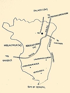
Narasapuram Mandal is one of the 19 mandals in the West Godavari district of the Indian state of Andhra Pradesh. Its headquarters are in Narasapuram, a town in the mandal. The mandal is bordered by the Godavari River to the north, the Bay of Bengal to the east, the Mogalthur mandal to the south, and the Palacole mandal to the west.

Biccavolu mandal is one of the 19 mandals in East Godavari district of the Indian state of Andhra Pradesh. It is under the administration of Rajahmundry revenue division and the headquarters are located at Biccavolu village. Biccavolu Mandal is bounded by Rayavaram Mandal towards South, Pedapudi Mandal towards East, Anaparthy Mandal towards west, Ramachandrapuram Mandal towards north. It is located ata distance of 41 kilometres from Rajahhmundry.
Lingapalem Mandal is one of 28 mandals in the Eluru district of Andhra Pradesh in India. Its headquarters are located in Lingapalem. It is bordered by T.Narasapuram and Chintalapudi in the North, Khammam district tin the West, Kamavarapukota mandal in the East, and Pedavegi mandal in the South.
Unguturu mandal is one of 28 mandals in the Eluru district of the Indian state of Andhra Pradesh. The headquarters are located at Unguturu. The mandal is bordered by Tadepalligudem mandal and Pentapadu mandal to the north, Nallajerla mandal to the west, Nidamarru mandal to the east, and by Dwaraka Tirumala mandal and Bhimadole mandal to the south
Akividu mandal is one of the 19 mandals in West Godavari district of the Indian state of Andhra Pradesh. The headquarters is located at Akividu town. The mandal is bordered by Nidamarru mandal to the west, Krishna district to the south, Tanuku and Undi mandal to the north and Kalla mandal to the east.
Attili mandal is one of the 46 mandals in West Godavari district of the Indian state of Andhra Pradesh. The headquarters are located in the town Attili. The mandal is bordered by Iragavaram mandal and Penumantra mandal to the north, Palacoderu mandal to the east, Ganapavaram mandal and Tanuku mandal to the west.

Bapulapadu mandal is one of the 25 mandals in Krishna district of the Indian state of Andhra Pradesh. The headquarters of this mandal is located at Bapulapadu town. The mandal is bordered by Nuzvid mandal and Agiripalle mandal to the north, West Godavari district to the east, Nandivada mandal to the south and Unguturu mandal to the west.
Kadiam Mandal is one of the 19 mandals in East Godavari District of Andhra Pradesh. As per census 2011, there are 7 villages.
Y. Ramavaram is one of the 22 mandals in Alluri Sitharama Raju district of Andhra Pradesh. As per census 2011, there are 137 villages in this mandal.
Pasaruginne is a village in Y. Ramavaram Mandal, East Godavari district in the state of Andhra Pradesh in India.

Konaseema district is a district between the tributaries of Godavari river in the Indian state of Andhra Pradesh. It was carved out of East Godavari district on 4 April 2022 by Y. S. Jagan Mohan Reddy's government. Amalapuram is the district headquarters and largest city.

