Garba Tula

Last updated

Garba Tula
(shortened to Garba)
Town
Garbatulla Masjid.jpg
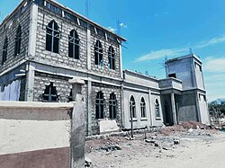
Jamia Mosque being built in Garba Tula town
Nickname: 
El Borte (From Borana Bitter Well)
Kenya adm location map.svg
Red pog.svg
Garba Tula
Location in Kenya
Coordinates: 0°31′36″N38°30′54″E / 0.52654°N 38.51492°E / 0.52654; 38.51492
CountryFlag of Kenya.svg  Kenya
County Isiolo County
Time zone UTC+3 (EAT)

Garba Tula (also spelled Garbatulla) and popularly nicknamed by the locals El Borte (meaning Bitter Well , probably due to its salty water) is a town in Isiolo County, Northern Kenya. The town has an urban population of about 5,500. [1] In 2007 it was up-graded to a District status. But with the new administrative sub-divisions of Kenya, Garba Tula is a sub-county of Isiolo County, as well as an administrative ward. [2]

The First Settlement of Indians was back in 1900. In the 1940s Garba Tulla was a very small village and only had three shops on the main road. Mr. Joseph Onyango became the first District Commissioner on 17 November 2007. The town has been known for its famous National School run by NCCK.

Garba Tula is located 120 km East of Isiolo town. The urban center of Mado Gashi is located about 100 km North East of Garba Tula. It is about 90 km to Maua town via Kinna, up to which the road is an all-weather one, and then tarmac which starts right at the gates of Meru National Park which is about 60 km away from Garba Tula town and about 14 km from Kinna town. The locals of the town are the Sakuye people who are of Bimaal origin.

Related Research Articles

<span class="mw-page-title-main">Trans-Nzoia County</span> County of Kenya

Trans-Nzoia County is a county in the former Rift Valley Province, Kenya, located between the Nzoia River and Mount Elgon, 380 km northwest of Nairobi. At its centre is the town of Kitale which is the capital and largest town. The county borders Bungoma to the west, Uasin Gishu and Kakamega to the south, Elgeyo-Marakwet to the east, West Pokot to the north and the Republic of Uganda to the Northwest. Trans Nzoia covers an area of 2495.5 square kilometres.

Meru is a town in eastern Kenya. It is the headquarters of the Meru County, and the seventh largest urban centre in the country. Meru urban center has a population of 80,191 residents (2019).

<span class="mw-page-title-main">Meru County</span> County in Kenya

Meru County is one of the 47 counties of Kenya. It borders Isiolo County to the north, Tharaka-Nithi County to the South, Nyeri County to the southwest and Laikipia County to the west. The home of the Meru people, Meru County has a population of 1.35 million people.

<span class="mw-page-title-main">Isiolo</span> District capital in Kenya

Isiolo is a town in Isiolo County, of which it is the capital. It is located in the upper eastern region of Kenya and is geographically considered the center of the country Kenya. It lies 285 kilometers north of the capital Nairobi. The town grew around the local military camps. Much of the population consists of Somali, Borana and Ameru community. The town has an estimated population of 78,250, most of them living around the outskirts of the town. Like most African cities, there has been a steady increase in the urban population in recent years, especially moving from as far as Moyale, Marsabit and Mandera. Isiolo town is also becoming a centre of interest because of its newly acquired status as a resort city cashing in on the popular Samburu and Shaba Game reserves, which have become preferred destinations after the famed Maasai Mara. Isiolo lies along the long A2 Road, leading towards Marsabit and Moyale much further north.

<span class="mw-page-title-main">Laikipia County</span> County in Kenya

Laikipia County is one of the 47 Counties of Kenya, located on the Equator in the former Rift Valley Province of the Country. Laikipia is a cosmopolitan County and is Listed as County number 31. The county has two major urban centres: Nanyuki to the southeast, and Nyahururu to the southwest. Its County government headquarters town is Rumuruti. The County lies between latitudes 0° 18" South and 0° 51" North and between longitudes 36° 11" and 37° 24' East. It borders Samburu County to the North, Isiolo County to the North East, Meru County to the East, Nyeri County to the South East, Nyandarua County to the South, Nakuru County to the South West and Baringo County to the West.

<span class="mw-page-title-main">Kericho County</span> County in Kenya

Kericho County is one of the 47 counties in Kenya. The county seats between longitude 35°02' and 35°40' East and between the equator and latitude 0°23' South with an altitude of about 2002m above sea level. It borders Uasin Gishu County to the North West, Baringo County to the North-East, Nandi County to the North-West, Nakuru County to the East and Bomet County to the South, Kisumu County to the Northwest and Nyamira County to the West. It has a population of 901,777 and an area of 2,111 km². Its capital and largest town is Kericho.

Kajiado is a town in Kajiado County, Kenya. The town is located 80 km (49.7 mi) south of Nairobi, along the Nairobi – Arusha highway. Kajiado has an urban population of 24,678. Local people are predominantly of the Maasai tribe.

<span class="mw-page-title-main">Marsabit County</span> County in Kenya

Marsabit County is a county in Kenya. Covering a surface area of 66,923.1 square kilometres. Marsabit is the second largest county by size in Kenya after Turkana county which has an area of 71,597.8 km2. Its capital is Marsabit and its largest town is Moyale. According to the 2019 census, the county has a population of 459,785. It is bordered to the North by Ethiopia, to the West by Turkana County to the South by Samburu County and Isiolo County, and to the East by Wajir County.

<span class="mw-page-title-main">Isiolo County</span> County in Kenya

Isiolo County is a county in the former Eastern Province of Kenya. Its population is 268,002 and its capital and largest city is Isiolo. Isiolo County is to be the first county to be developed as part of the Kenya Vision 2030 program. Other upcoming urban centres are: Garbatulla, Modogashe, Kinna, Merti and Oldonyiro.The county is home to Sakuye and Borana tribes but also has a significant number of people from Turkana, Samburu, Gabra, Garre and Meru communities.

<span class="mw-page-title-main">Kajiado County</span> County in Kenya

Kajiado County is a county in the former Rift Valley Province of Kenya. As of 2019, Kajiado county spanned an area of 21,292.7 km2, with a recorded population of 1,117,840. The county borders Nairobi and to its south it borders the Tanzanian regions of Arusha and Kilimanjaro. The county capital is Kajiado, but the largest town is Ongata Rongai. Its main tourist attraction is its wildlife.

Mado Gashi is a small remote town in Kenya. There are no large cities near Mado Gashi. It is connected by road to Isiolo, Wajir and Garissa. Mado Gashi has an unpaved airstrip. The village of Garba Tula is located 75 km west of Mado Gashi. Residential areas in Mado Gashi are called Bulas. Bula Market, Bula Digs and Bula Jua are among the big Bulas found in Mado Gashi.

<span class="mw-page-title-main">Local authorities of Kenya</span> Bodies controlling local governance in urban areas in Kenya

Local authorities in Kenya are the bodies controlling local governance in urban areas in Kenya.

<span class="mw-page-title-main">Makueni County</span> County in Kenya

Makueni County is a county in the former Eastern Province of Kenya. Its capital town is Wote.The largest town is Emali town. Emali town is also an important market and stop over for the Standard Gauge Railway (SGR). Emali town is multicultural and adds diversity to Makueni county.The county has a population of 987,653. The county lies between Latitude 1° 35' and 2° 59' South and Longitude 37° 10' and 38° 30' East. It borders Machakos County to the North, Kitui County to the East, Taita Taveta County to the South and Kajiado County to the West and covers an area of 8,008.9 km2.

<span class="mw-page-title-main">Garissa County</span> County in Kenya

Garissa County is an administrative county in Kenya. It is located in Eastern Kenya bordering Somalia to the East, Wajir County and Isiolo County to the North, Tana River County to the West and Lamu County to the South. Its capital and largest urban area is Garissa.

<span class="mw-page-title-main">Mandera County</span> County in Kenya

Mandera County is one of the counties in Kenya. Its capital and largest town is Mandera. The county is bordered by Ethiopia to the north, Somalia to the east and Wajir County to the southwest. According to the 2019 census, the county has a population of 1,200,890 and an area of 25,939.8 square kilometres (10,015.4 sq mi). The main economic activity in the county is pastoralism, while others include cross-border trade with Ethiopia, artisanal mining, beekeeping, and agriculture along the Dawa River.

<span class="mw-page-title-main">Sub-Counties of Kenya</span>

Sub-counties, also known as Districts, are the decentralised units through which government of Kenya provides functions and services. At national level, sub-counties take a more administrative function like security, statistical purposes, provision of government services, etc. Even though the sub-counties are divisions of counties, powers to create new national sub-counties lies with the national government. As of 2023, there are 314 sub-counties, compared to 290 constituencies. A deputy county commissioner is appointed by the state to lead each sub-county. The sub-counties are further divided into divisions, locations and sub-locations.

Isiolo District was an administrative district in Eastern Province of Kenya, with its capital at Isiolo town.

<span class="mw-page-title-main">Lamu–Garissa–Isiolo Road</span>

Lamu–Garissa–Isiolo Road, is a road in Kenya, and is part of the Lamu-Garissa-Isiolo-Lokichar Road, which itself is a component of the Lamu Port and Lamu-Southern Sudan-Ethiopia Transport Corridor (LAPSSET) Project.

Merti is a small town in Isiolo County in northern Kenya. Merti is one of the upcoming urban centres in Isiolo County. It is also the capital of Merti sub-county, which has a population of 47,206.

Isiolo–Mandera Road, is a road in Kenya. It is a major transport route linking north-central Kenya to Kenya's northeast. The counties that the road traverses are generally arid, and have hitherto been undeserved. This road project is the largest and most expensive infrastructure project in northeastern Kenya since the country became independent in 1963.

References

  1. https://web.archive.org/web/20110718022538/http://www.ilri.cgiar.org/html/Urban%20Poverty%20all%20Kenya%20Province%20through%20Location%20Final.xls
  2. "Isiolo County Integrated Development Plan, CIDP 2018-2022" (PDF). County Government of Isiolo. Archived from the original (PDF) on 2 August 2019. Retrieved 2 August 2019.