County Kerry is a county in Ireland. It is located in the South-West Region and forms part of the province of Munster. It is named after the Ciarraige who lived in part of the present county. The population of the county was 155,258 at the 2022 census, a 5.1% increase from the 2016 census.

Tralee is the county town of County Kerry in the south-west of Ireland. The town is on the northern side of the neck of the Dingle Peninsula, and is the largest town in County Kerry. The town's population was 23,691 as of the 2016 census, thus making it the eighth largest town, and 14th largest urban settlement, in Ireland. Tralee is well known for the Rose of Tralee International Festival, which has been held annually in August since 1959.

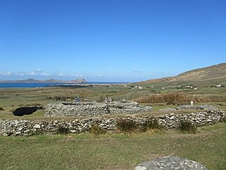
A clochán or beehive hut is a dry-stone hut with a corbelled roof, commonly associated with the south-western Irish seaboard. The precise construction date of most of these structures is unknown with the buildings belonging to a long-established Celtic tradition, though there is at present no direct evidence to date the surviving examples before c. 700 CE. Some associated with religious sites may be pre-Romanesque, some consider that the most fully intact structures date after the 12th century or later. It is where monks lived.

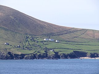
The Dingle Peninsula is the northernmost of the major peninsulas in County Kerry. It ends beyond the town of Dingle at Dunmore Head, the westernmost point of Ireland and arguably Europe.

Ballyferriter is a Gaeltacht village in County Kerry, Ireland. It is in the west of the Corca Dhuibhne (Dingle) peninsula and according to the 2002 census, about 75% of the town's population speak the Irish language on a daily basis. The village is named after the Norman-Irish Feiritéar family who settled in Ard na Caithne in the late medieval period. The last Chief of the Name was the seventeenth-century Bard and leader Piaras Feiritéar who was executed. The older Irish name for the village An B[h]uailtín is still used locally.

Camp is a village near the Slieve Mish Mountains in County Kerry, Ireland, on the Dingle Peninsula. It is close to the Dingle Way and is a destination for tourists.
Leacanabuaile is a stone ringfort (cashel) and National Monument in County Kerry, Ireland. Leacanabuaile is immediately northwest of Cahergal, 3 km (1.9 mi) northwest of Cahirciveen.
St. Manchan's Oratory, also called An Teampall Geal is a medieval oratory and National Monument in County Kerry, Ireland.

Glanfahan is a townland on the Dingle Peninsula, Ireland, notable for its large collection of clocháns, which form a National Monument.

Church Island is a medieval Christian monastery and National Monument located in Valentia Harbour, Ireland.

Church Island is a medieval Christian monastery and National Monument located in Lough Currane, Ireland.
Caherdorgan North is a National Monument located in County Kerry, Ireland.
Maumanorig or Kilcolman is the site of the remains of a medieval Christian monastery and National Monument located on the Dingle Peninsula, County Kerry, Ireland.

Ballywiheen is a medieval Christian site and National Monument located on the Dingle Peninsula, Ireland.

Kilmalkedar is a medieval ecclesiastical site and National Monument located in County Kerry, Ireland.

Rahinnane Castle is a tower house and National Monument located in County Kerry, Ireland.
Ballynavenooragh is a stone fort and National Monument located in County Kerry, Ireland.
Rinn an Chaisleáin or Castle Point is a National Monument on Great Blasket Island, Ireland.
Reenconnell is a medieval Christian site and National Monument located on the Dingle Peninsula, County Kerry, Republic of Ireland.


