
Gary R. Lock is a British archaeologist and emeritus professor at the School of Archaeology, University of Oxford. [1] He is noted for his contributions to computational archaeology.
Gary R. Lock is a British archaeologist and emeritus professor at the School of Archaeology, University of Oxford. [1] He is noted for his contributions to computational archaeology.
In the 1980s Lock became involved in computational archaeology, working on a database for Danebury, an iron age hillfort in Hampshire which was excavated under the direction of Barry Cunliffe. [2] In 1987 he was co-author of Computer Archaeology in the Shire Archaeology series. Interest in computational archaeology and prehistoric hillforts are also evidenced in more recent work, for example Using computers in archaeology: towards virtual pasts (2003) and his contribution to a project to create a comprehensive database of prehistoric hillforts in the British Isles, the Atlas of Hillforts of Britain and Ireland (launched online in 2017). [3]
Lock has been a fellow of Kellogg College since 1993, serving as the secretary to its governing body from 1997 to 1998 and Dean of Degrees in 2010. [4]
He was formerly the chair of Computer Applications and Quantitative Applications in Archaeology (CAA) International. [5]
He has been involved with archaeological projects on the continent:

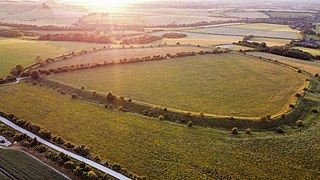
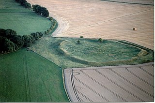
The Uffington White Horse is a prehistoric hill figure, 110 m (360 ft) long, formed from deep trenches filled with crushed white chalk. The figure is situated on the upper slopes of Whitehorse Hill in the English civil parish of Uffington in Oxfordshire, some 16 km (10 mi) east of Swindon, 8 km (5.0 mi) south of the town of Faringdon and a similar distance west of the town of Wantage; or 2.5 km (1.6 mi) south of Uffington. The hill forms a part of the scarp of the Berkshire Downs and overlooks the Vale of White Horse to the north. The best views of the figure are obtained from the air, or from directly across the Vale, particularly around the villages of Great Coxwell, Longcot, and Fernham.

A hillfort is a type of fortified refuge or defended settlement located to exploit a rise in elevation for defensive advantage. They are typical of the late European Bronze Age and Iron Age. Some were used in the post-Roman period. The fortification usually follows the contours of a hill and consists of one or more lines of earthworks or stone ramparts, with stockades or defensive walls, and external ditches. If enemies were approaching, the civilians would spot them from a distance.

Maiden Castle is an Iron Age hillfort 1.6 mi (2.6 km) southwest of Dorchester, in the English county of Dorset. Hill forts were fortified hill-top settlements constructed across Britain during the Iron Age.
Computational archaeology describes computer-based analytical methods for the study of long-term human behaviour and behavioural evolution. As with other sub-disciplines that have prefixed 'computational' to their name, the term is reserved for methods that could not realistically be performed without the aid of a computer.

Sir Barrington Windsor Cunliffe,, known as Barry Cunliffe, is a British archaeologist and academic. He was Professor of European Archaeology at the University of Oxford from 1972 to 2007. Since 2007, he has been an emeritus professor.

Uffington Castle is an early Iron Age univallate hillfort in Oxfordshire, England. It covers about 3.2 ha and is surrounded by two earth banks separated by a ditch with an entrance in the western end. A second entrance in the eastern end was apparently blocked up a few centuries after it was built. The original defensive ditch was V-shaped with a small box rampart in front and a larger one behind it. Timber posts stood on the ramparts. Later the ditch was deepened and the extra material dumped on top of the ramparts to increase their size. A parapet wall of sarsen stones lined the top of the innermost rampart. It is very close to the Uffington White Horse on White Horse Hill.

Danebury is an Iron Age hillfort in Hampshire, England, about 19 kilometres (12 mi) north-west of Winchester. The site, covering 5 hectares, was excavated by Barry Cunliffe in the 1970s. Danebury is considered a type-site for hill forts, and was important in developing the understanding of hillforts, as very few others have been so intensively excavated.

Cadbury Castle is a Bronze and Iron Age hillfort in the civil parish of South Cadbury in the English county of Somerset. It is a scheduled monument and has been associated with King Arthur's legendary court at Camelot.
Segsbury Camp or Segsbury Castle is an Iron Age hillfort on the crest of the Berkshire Downs, near the Ridgeway above Wantage, in the Vale of White Horse district of Oxfordshire, England. It is in Letcombe Regis civil parish and is also called Letcombe Castle.
Alfred's Castle is a small Iron Age hill fort, situated at grid reference SU277822, behind Ashdown Park in the civil parish of Ashbury in Oxfordshire. It lies 2–3 km south of the Ridgeway and is protected as a Scheduled Ancient Monument.
Mellor hill fort is a prehistoric site in North West England dating from the British Iron Age – about 800 BC to 100 AD. Situated on a hill in Mellor, Greater Manchester, on the western edge of the Peak District, the hill fort overlooks the Cheshire Plain. Although the settlement was founded during the Iron Age, evidence exists of activity on the site as far back as 8,000 BC; during the Bronze Age the hill may have been an area where funerary practices were performed. Artefacts such as a Bronze Age amber necklace indicate the site was high status and that its residents took part in long-distance trade. The settlement was occupied into the Roman period. After the site was abandoned, probably in the 4th century, it was forgotten until its rediscovery in the 1990s.
Hillforts in Britain refers to the various hillforts within the island of Great Britain. Although the earliest such constructs fitting this description come from the Neolithic British Isles, with a few also dating to later Bronze Age Britain, British hillforts were primarily constructed during the British Iron Age. Some of these were apparently abandoned in the southern areas that were a part of Roman Britain, although at the same time, those areas of northern Britain that remained free from Roman occupation saw an increase in their construction. Some hillforts were reused in the Early Middle Ages, and in some rarer cases, into the Later Medieval period as well. By the early modern period, these had essentially all been abandoned, with many being excavated by archaeologists in the nineteenth century onward.

The river Najerilla is a tributary of the river Ebro, Spain's most voluminous river. The Najerilla rises in the province of Burgos and then flows through La Rioja.

Hillforts in Scotland are earthworks, sometimes with wooden or stone enclosures, built on higher ground, which usually include a significant settlement, built within the modern boundaries of Scotland. They were first studied in the eighteenth century and the first serious field research was undertaken in the nineteenth century. In the twentieth century there were large numbers of archaeological investigations of specific sites, with an emphasis on establishing a chronology of the forts. Forts have been classified by type and their military and ritual functions have been debated.
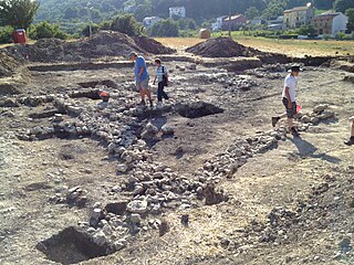
The Sangro Valley Project is an Anglo-American ongoing archaeological excavation in Abruzzo, Italy. It is notable for its revolutionary interpretation of Samnium as a dynamic participant in the history of the Adriatic as well as its early adoption of modern excavation technologies, such as GIS. The project currently managed by Oberlin College in collaboration with Oxford University, Durham University and the Soprintendenza per i Beni Archeologici dell'Abruzzo, is a multi-disciplinary team of specialists from Canada, Italy, the United Kingdom, and the United States.
Virtual archaeology is a term introduced in 1990 by archaeologist and computer scientist Paul Reilly to describe the use of computer based simulations of archaeological excavations. Since that time, scientific results related to virtual archaeology were annually discussed, among others, at Computer Applications and Quantitative Methods in Archaeology (CAA). The keyword "visualization" defined the aim of the virtual archaeology in the London Charter Initiative:
It should be made clear to users what a computer-based visualization seeks to represent, for example the existing state, an evidence-based restoration or an hypothetical reconstruction of a cultural heritage object or site, and the extent and nature of any factual uncertainty.
James K. Hoffmeier is an American Old Testament scholar, an archaeologist and an egyptologist. He was Professor of Old Testament and Ancient Near Eastern History and Archaeology at Trinity Evangelical Divinity School.
The Institute of Archaeology is an academic department of the University of Oxford devoted to the teaching and research of archaeology. Together with the Research Laboratory for Archaeology and the History of Art, it forms part of the School of Archaeology. Its current director is Chris Gosden.
Beacon Hill, also known as Harting Beacon, is a hillfort on the South Downs, in the county of West Sussex in southern England. The hillfort is located in the parish of Elsted and Treyford, in Chichester District. It is a Scheduled Ancient Monument with a list entry identification number of 1015915. The hilltop enclosure is dated to the Late Bronze Age, from the 8th to 6th centuries BC. The hillfort defences were renewed during the Late Iron Age.
John Lloyd was a British classical archaeologist.
| International | |
|---|---|
| National | |
| Academics | |
| Other | |
| | This biographical article about an archaeologist is a stub. You can help Wikipedia by expanding it. |