
Gatwick Racecourse was a racecourse in the county of Surrey, England near to Horley and Lowfield Heath. [1] It was in use from 1891 to 1940 when it was closed at the start of the Second World War. The land is now part of London Gatwick Airport.
Gatwick Racecourse was a racecourse in the county of Surrey, England near to Horley and Lowfield Heath. [1] It was in use from 1891 to 1940 when it was closed at the start of the Second World War. The land is now part of London Gatwick Airport.
In 1890, the descendants of the de Gatwick family sold the area to the newly established Gatwick Race Course Company. A farmhouse was built around 1890, with extensive stabling.
In 1891, Gatwick Racecourse opened beside the London–Brighton railway, and a dedicated station including sidings for horse boxes. [2] The course held steeplechase and flat races. [2]
The first race meeting was on 7 October 1891. [3] Its race distances were 5 furlongs to 2 miles flat and 2 miles to 4 miles 856 yards National Hunt. During the Great War a Grand National substitute race, renamed The Racecourse Association Steeplechase for 1916 and the War National in 1917 and 1918, was hosted by Gatwick, although its principal race was the Gatwick Cup. From around 1930, the course was managed by George Gurton, who moved there from the Colchester area of Essex with his wife Ruby and two sons, Eustace Guy and Oswald George.[ citation needed ]
An aerodrome was opened around 1930 at the southeastern edge of the property, with a circular terminal building called The Beehive added in 1936. There is also a pub at nearby Tinsley Green called The Beehive. The aerodrome would eventually develop into Gatwick Airport. When the Second World War broke out in 1939 the military authorities requisitioned the open spaces of the racecourse for the War preparations. A final two day National Hunt meeting was staged on 27/28th March 1940, whilst a final Flat race meeting took place on the 14/15th June 1940. [4]

After the Second World War, the stables and racecourse were used for training by, among others, Jack Holt. The surrounding land was farmed by George Gurton and subsequently by his elder son, Eustace Guy Gurton.
The Gurton family lived in the farmhouse until 1959 and farmed the area, using the land for mixed arable. Private trainers rented the stables and used the defunct course for training. In 1957, the racecourse was chosen as the site of the second major London airport, and the stables and house were demolished around 1960. A lodge house still remains on Povey Cross Road. The Gurton family emigrated to Australia in 1959. Many of Gurton's descendants still live in the surrounding Horley, Crawley and Charlwood areas. Some members of the family are buried at Charlwood Parish Church cemetery.
The airport was expanded onto the site of the racecourse and as a result, left no evidence that there was ever one there, but there is a restaurant named the "Racecourse Restaurant" in Gatwick Airport. There are also roads around the airports boundaries called "Racecourse Road" and "Furlong Way". The racecourse's bandstand was relocated to Queens Square in Crawley. Following the redevelopment of Queens Square in 2017 the bandstand was relocated to Memorial Gardens in Crawley.
Aintree Racecourse is a racecourse in Aintree, Metropolitan Borough of Sefton, Merseyside, England, bordering the city of Liverpool. The racecourse is the venue for the Grand National steeplechase, which takes place annually in April over three days. Aintree also holds meetings in May, October (Sunday), November and December.

Gatwick Airport railway station is on the Brighton Main Line in West Sussex, England. It serves Gatwick Airport, 26 miles 47 chains (42.8 km) down the line from London Bridge via Redhill. The platforms are about 70 metres (230 ft) to the east of the airport's South Terminal, with the ticket office above the platforms and station entrances and exits directly connected to the terminal. The station is also connected to the airport's North Terminal by the Airport Shuttle people-mover. Gatwick Airport was the busiest station in South East England region from 2017 to 2018. There have been two stations at Gatwick, sited about 0.85 miles (1.37 km) from each other. It is the busiest station in both West Sussex and South East England, and the sixth busiest station in the UK outside of London.

Newbury Racecourse is a racecourse and events venue in the civil parish of Greenham, adjoining the town of Newbury in Berkshire, England. It has courses for flat races and over jumps. It hosts one of Great Britain's 36 annual Group 1 flat races, the Lockinge Stakes.

Horley is a town in the borough of Reigate and Banstead in Surrey, England, south of the towns of Reigate and Redhill. The county border with West Sussex is to the south with Crawley and Gatwick Airport close to the town.

Charlwood is a village and civil parish in the Mole Valley district of Surrey, England. It is immediately north-west of London Gatwick Airport in West Sussex, close west of Horley and north of Crawley. The historic county boundary between Surrey and Sussex ran to the south of Gatwick Airport. Boundaries were reformed in 1974 with the county boundary between Surrey and West Sussex, delineated by the Sussex Border Path, runninh along the northern perimeter of the airport, and the southern extent of Charlwood.

Cheltenham Racecourse at Prestbury Park, near Cheltenham, Gloucestershire, England, hosts National Hunt horse racing. Racing at Cheltenham took place in 1815, but comprised only minor flat races on Nottingham Hill. The first racing on Cleeve Hill was on Tuesday 25 August 1818 when the opening race was won by Miss Tidmarsh, owned by Mr E Jones. It was a year later when the results were printed in the Racing Calendar when a programme of flat racing was watched by the Duke of Gloucester who donated 100 Guineas to the prize fund. By 1831 races were being staged at Prestbury, although not on the present day course. In 1834 the Grand Annual Steeplechase was run for the first time. In 1839 Lottery won the Grand Annual having previously won the first Aintree Grand National. In 1840 the meeting transferred to Andoversford for a brief period, only to return to Prestbury in 1847. 1902 was a notable year in that racing moved to the present course at Prestbury Park. The new stands were completed in 1914 and the present day Festival races, as we know them, began to take shape. The Cheltenham Gold Cup, over 3 ¼ miles, was run for the first time in 1924, with the Champion Hurdle following in 1927.
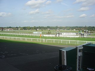
Sandown Park is a horse racing course and leisure venue in Esher, Surrey, England, located in the outer suburbs of London. It hosts 5 Grade One National Hunt races and one Group 1 flat race, the Eclipse Stakes. It regularly has horse racing during afternoons, evenings and on weekends, and also hosts many non-racing events such as trade shows, wedding fairs, toy fairs, car shows and auctions, property shows, concerts, and even some private events. It was requisitioned by the War Department from 1940-1945 for World War II. The venue has hosted bands such as UB40, Madness, Girls Aloud, Spandau Ballet and Simply Red. The racecourse is close to Esher railway station, served by trains from London Waterloo. There is a secondary exit from Esher station which is open on race days, this exit leads directly into the racecourse and Lower Green, Esher.

Wetherby Racecourse is a racecourse situated near the market town of Wetherby in West Yorkshire, England, located 12 miles (19 km) from Leeds city centre. For most of its history the course has hosted only National Hunt racing but staged its first Flat racing fixture on 26 April 2015.
Hurst Park Racecourse was a racecourse at Moulsey Hurst, West Molesey, Surrey, near the River Thames. It was first laid out in 1890 and held its last race in 1962.
Folkestone Racecourse was a thoroughbred horse racing venue in southeast England, until it closed in 2012. It is located in Westenhanger, by junction 11 of the M20 motorway and about 6 miles (9.7 km) west of Folkestone. The course remains closed and all running rail and steeplechase fences have been removed. In May 2016 it was revealed that the land covered by the racecourse forms part of a plan to develop and build housing. It is now unkempt and in a state of disrepair.

As of 2011 there were 102 listed buildings and structures in the English borough of Crawley, West Sussex. Two others have subsequently gained listed status. The Borough of Crawley is based on the town of the same name, located approximately halfway between London and Brighton. Although Crawley expanded substantially after World War II when it was designated a New Town by an Act of Parliament, many older buildings remain.
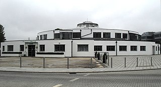
The Beehive is the original terminal building at Gatwick Airport, England. Opened in 1936, it became obsolete in the 1950s as the airport expanded. In 2008, it was converted into serviced offices, operated by Orega, having served as the headquarters of franchised airline GB Airways for some years before that. It was the world's first fully integrated airport building, and is considered a nationally and internationally important example of airport terminal design. The Beehive is a part of the City Place Gatwick office complex. The 20,000-square-foot (1,900 m2) former terminal building is on a 2-acre (0.81 ha) site.

St Michael and All Angels Church is a church in Lowfield Heath, a depopulated former village in the Borough of Crawley, West Sussex, England. Built by the Gothic Revival architect William Burges in 1867 to serve the village, it declined in importance as Lowfield Heath was gradually appropriated for the expansion of London Gatwick Airport and of its related development. The last Anglican service was held there in 2004, but the church reopened in 2008 as a Seventh-day Adventist place of worship. The building has Grade II* listed status, which identifies it as a "particularly important building of more than special interest" and of national importance. It is also the only building remaining in the former village from the era before the airport existed: every other structure was demolished, and the church now stands among warehouses, depots and light industrial units.

Lowfield Heath is a former village within the boundaries of the Borough of Crawley, West Sussex, England. Situated on the main London to Brighton road approximately 27 miles (43 km) south of London and 2 miles (3.2 km) north of Crawley, it was gradually rendered uninhabitable by the expansion of London Gatwick Airport immediately to the north.

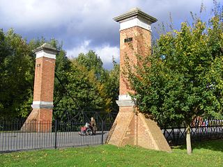
Tinsley Green is an area in the Borough of Crawley, one of seven local government districts in the English county of West Sussex. Originally a hamlet in the parish of Worth, it was absorbed by the New Town of Crawley in the 1940s and became part of the Pound Hill neighbourhood. As well as houses, farms and woodland, it became the site of the 1930s aerodrome at Gatwick—now London Gatwick Airport. The airport's first railway station was briefly known as Tinsley Green. The game of marbles has a strong local tradition, and Tinsley Green's pub hosts the British and World Marbles Championship each year.
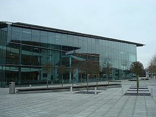
City Place Gatwick is an office complex located on the property of London Gatwick Airport in Crawley, West Sussex, England. The complex includes four buildings: The Beehive, an approximately 20,000-square-foot (1,900 m2) former terminal building at Gatwick Airport located on a 2.0-acre (0.81 ha) site; 1 City Place a 131,500-square-foot (12,220 m2) facility on a 4.2-acre (1.7 ha) site, 2 City Place, a 85,000-square-foot (7,900 m2) building on a 1.9 acres (0.77 ha) plot, and 3 City Place, a 65,000-square-foot (6,000 m2) building on a 1.06-acre (0.43 ha) plot. Hamiltons Architects designed the L-shaped 3 City Place.

Fernhill is a hamlet close to Gatwick Airport in West Sussex, England. Its fields and farmhouses formerly straddled the county boundary between Surrey and West Sussex, but since 1990 the whole area has been part of the county of West Sussex and the borough of Crawley. Fernhill is bounded on three sides by motorways and the airport. A fatal aeroplane crash occurred here in 1969.

Lanark Racecourse was a Scottish horse racing venue, situated in the small town of Lanark in Scotland's Central Belt, 25 miles (40 km) from Glasgow. It was reputedly founded by King William the Lion of Scotland (1165-1214).
Gatwick Airport was in Surrey until 1974, when it became part of West Sussex as a result of a county boundary change. The original, pre-World War II airport was built on the site of a manor in the parish of Charlwood. The land was first used as an aerodrome in the 1920s, and in 1933 commercial flights there were approved by the Air Ministry.