
Al Ain is a border city on the eastern side of Tawam oasis and the seat of the administrative division, the Al Ain Region, in the Emirate of Abu Dhabi, United Arab Emirates. The city is bordered to the east by the Omani town of Al-Buraimi in the Al Buraimi Governorate. It is the largest inland city in the Emirates, the fourth-largest city, and the second-largest in the Emirate of Abu Dhabi. The freeways connecting Al-Ain, Abu Dhabi, and Dubai form a geographic triangle in the country, each city being roughly 130 kilometres (81 mi) from the other two.
Nubians are a Nilo-Saharan ethnic group indigenous to the region which is now northern Sudan and southern Egypt. They originate from the early inhabitants of the central Nile valley, believed to be one of the earliest cradles of civilization. In the southern valley of Egypt, Nubians differ culturally and ethnically from Egyptians, although they intermarried with members of other ethnic groups, especially Arabs. They speak Nubian languages as a mother tongue, part of the Northern Eastern Sudanic languages, and Arabic as a second language.
Nubiology is the scientific study of ancient Nubia. The term was coined by Kazimierz Michałowski.

Jebel Barkal or Gebel Barkal is a mesa or large rock outcrop located 400 km north of Khartoum, next to Karima in Northern State in Sudan, on the Nile River, in the region that is sometimes called Nubia. The jebel is 104 m tall, has a flat top, and came to have religious significance for both ancient Kush and ancient Egyptian occupiers. In 2003, the mountain, together with the extensive archaeological site at its base, were named as the center of a World Heritage Site by UNESCO. The Jebel Barkal area houses the Jebel Barkal Museum.
In 2003, the National Corporation for Antiquities and Museums (NCAM) of the Republic of Sudan launched an international appeal for rescuing the archaeological sites which are going to be inundated by the floods of the Hamdab High Dam currently under construction near Merowe in the Fourth Cataract region of northern Sudan. The new reservoir will cover about 170 km of the Nile valley, and its completion is scheduled for 2007.
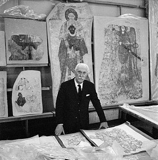
H.U.N.E., the Humboldt University Nubian Expedition is one of a group of international expeditions which followed this appeal and joined the Merowe Dam Archaeological Salvage Project (MDASP). H.U.N.E. is based at the Institute of Northeast African Archaeology and Cultural Studies at the Humboldt University of Berlin, Germany. Its main aim is the complete recording of all archaeological sites, including rock art sites, in its concession area by intensive foot surveys and the excavation of chosen representative sites of each archaeological period. The H.U.N.E. concession area comprises four main islands, Us, Sur, Sherari and Shiri and a stretch on the left bank of the Nile from Gebel Musa to the market village of Salamat.
Results of the first two campaigns in the years 2004 and 2005 comprised the discovery of more than 700 archaeological sites and the excavation of a Neolithic settlement site, burials of the Kerma period, and two churches of the Christian era. Apart from rescuing the archaeological sites, H.U.N.E. also took efforts to document the traditions and customs of the local inhabitants of the Dar al-Manasir region, which belong to the Manasir tribe. Their material culture, economic life and poetry are recorded as well.

The Kharga Oasislit. 'the outer'; Coptic: (ϯ)ⲟⲩⲁϩ ⲛ̀ϩⲏⲃ(di)wah enhib, "Oasis of Hib", (ϯ)ⲟⲩⲁϩ ⲙ̀ⲯⲟⲓ(di)wah empsoi "Oasis of Psoi") is the southernmost of Egypt's five western oases. It is located in the Western Desert, about 200 km to the west of the Nile valley. "Kharga" or "El Kharga" is also the name of a major town located in the oasis, the capital of New Valley Governorate. The oasis, which was known as the 'Southern Oasis' to the Ancient Egyptians, the 'outer' to the Greeks and Oasis Magna to the Romans, is the largest of the oases in the Libyan desert of Egypt. It is in a depression about 160 km long and from 20 km to 80 km wide. Its population is 67,700 (2012).

The Eastern Desert is the part of the Sahara desert that is located east of the Nile river. It spans 223,000 square kilometres (86,000 sq mi) of northeastern Africa and is bordered by the Nile river to the west and the Red Sea and Gulf of Suez to the east. It extends through Egypt, Eritrea, Sudan and Ethiopia. The Eastern Desert consists of a mountain range which runs parallel to the coast, wide sedimentary plateaus extending from either side of the mountains and the Red Sea coast. The rainfall, climate, vegetation and animal life sustained in the desert varies between these different regions. The Eastern Desert has been a mining site for building materials, as well as precious and semi-precious metals, throughout history. It has historically contained many trade routes leading to and from the Red Sea, including the Suez Canal.
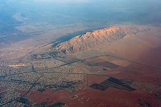
Jabal Hafeet is a mountain in the region of Tawam, on the border of the United Arab Emirates and Oman, which may be considered an outlier of the Hajar Mountains in Eastern Arabia. Due to its proximity to the main Hajar range, the mountain may be considered as being part of the Hajar range. To the north is the UAE city of Al Ain, in the Eastern Region of the Emirate of Abu Dhabi, and the adjacent Omani town of Al-Buraimi.

ʿAin Ghazal is a Neolithic archaeological site located in metropolitan Amman, Jordan, about 2 km north-west of Amman Civil Airport. The site is remarkable for being the place where the ʿAin Ghazal statues were found, which are among the oldest large-sized statues ever discovered.

Tarhuna wa Msalata was a district of Libya until 2007. Between 1988 and 1995 there existed the Tarhuna District, which became Tarhuna wa Msalata between 2001 and 2007. It consisted of twenty-six Basic People's Congresses, similar to townships, and its capital was Tarhuna. In the 2007 administrative reorganization the territory formerly in Tarhuna wa Msalata was transferred to Murqub District.
Gabal Elba, or Elba Mountain, is a peak and, in general, includes the associated mountainous area in the Halaib Triangle of Northeast Africa. Despite being claimed by both Egypt and Sudan, the area is currently under Egyptian control.
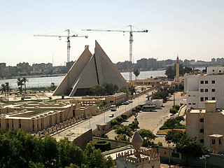
Minya is the capital of the Minya Governorate in Upper Egypt. It is located approximately 245 km (152 mi) south of Cairo on the western bank of the Nile River, which flows north through the city.

Al-'Ain al-Sokhna is a town in the Suez Governorate, lying on the western shore of the Red Sea's Gulf of Suez. It is situated 55 kilometres (34 mi) south of Suez and approximately 120 kilometres (75 mi) east of Cairo.
Dilling is a Hill Nubian language spoken in the northwestern Nuba Mountains in the south of Sudan. It is spoken by around 12,000 people in the town of Dilling and surrounding hills, including Kudur. Ethnologue reports that Dilling is moribund, with only older adults speaking the language and not using it with their children. All speakers also use Sudanese Arabic. The Dilling call themselves Warki, while the Dilling speakers of Kudur call themselves Kwashe. Another ethnic minority that speak Dilling are the Debri people, an ethnic group of several thousand people from South Kordofan in Sudan

Ba'ja is a Neolithic village 14 kilometres (8.7 mi) north of Petra, Jordan. Like the nearby site of Basta, the settlement was built in c. 7000 BC, during the PPNB period. Ba'ja lies at an altitude of approximately 1,160 metres (3,810 ft), and is only accessible with a climbing route through a narrow, steep canyon. It is one of the largest neolithic villages in the Jordan area.

The Daju kingdom was a medieval monarchy that existed in Darfur (Sudan) from possibly the 12th–15th century. Its name stems from the Daju people, the ruling ethnic group. The Daju were eventually ousted from power by the Tunjur and the last Daju king subsequently fled to present-day Chad. The sources for the Daju kingdom are almost entirely local traditions collected in the 19th and 20th century and mentions by medieval Arab historians.
The area currently known as the United Arab Emirates (UAE) was formerly populated by inhabitants of a number of coastal and inland settlements, with human remains pointing to a pattern of transmigration and settlement as far back as 125,000 years. Prehistoric settlement in the UAE spanned the Neolithic, with a number of distinctive eras of ancient settlement including the Stone Age Arabian Bifacial and Ubaid cultures from 5,000 to 3,100 BCE; the Hafit period with its distinctive beehive shaped tombs and Jemdet Nasr pottery, from 3,200 to 2,600 BCE; the Umm Al Nar period from 2,600 to 2,000 BCE; the Wadi Suq culture from 2,000 to 1,300 BCE and the three Iron Ages of the UAE.
Gebel Ramlah is a region in the Western Desert of southern Egypt that was occupied throughout the African Pastoral Neolithic. Archaeological research has focused primarily on individual burial sites and six pastoral cemeteries, including the earliest known infant cemetery in the world. The Gebel Ramlah cemeteries were active during the Final Neolithic in the fifth millennium BC. Ongoing excavation has uncovered over 200 human burials and elaborate grave goods. Research studies have been done on the pottery, mollusk shells, archaeobotanical remains, and skeletal remains found throughout the sites.
Zeidan A. Kafafi is a Jordanian archaeologist and academic who has directed and otherwise contributed to numerous excavations in and around Jordan and has assisted the institutional development of local academic institutions. He is a Professor Emeritus who recently served as the President of Yarmouk University.

Gebel Adda was a mountain and archaeological site on the right bank of the Nubian Nile in what is now southern Egypt. The settlement on its crest was continuously inhabited from the late Meroitic period to the Ottoman period, when it was abandoned by the late 18th century. It reached its greatest prominence in the 14th and 15th centuries, when it seemed to have been the capital of late kingdom of Makuria. The site was superficially excavated by the American Research Center in Egypt just before being flooded by Lake Nasser in the 1960s, with much of the remaining excavated material, now stored in the Royal Ontario Museum in Canada, remaining unpublished. Unearthed were Meroitic inscriptions, Old Nubian documents, a large amount of leatherwork, two palatial structures and several churches, some of them with their paintings still intact. The nearby ancient Egyptian rock temple of Horemheb, also known as temple of Abu Oda, was rescued and relocated.

