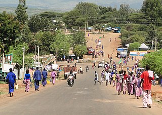
Karat is a town in south-western Ethiopia and the capital of the Konso Zone in the new South Ethiopia Regional State. Situated 20 km north of the Sagan River, this town has a latitude and longitude of 5°15′N37°29′E and an elevation of 1,650 metres (5,410 ft). It is also called Pakawle by some of the neighboring inhabitants. The town and the surrounding villages were inscribed on the UNESCO World Heritage List in 2011 as a cultural landscape for its unique cultural traditions and importance for the Konso people.
Dila is a market town and separate woreda in southern Ethiopia. The administrative center of the Gedeo Zone in the Southern Nations, Nationalities, and Peoples Region (SNNPR), it is located on the main road from Addis Ababa to Nairobi. The town has a longitude and latitude of 6°24′30″N38°18′30″E, with an elevation of 1570 meters above sea level. It was part of Wenago woreda and is currently surrounded by Dila Zuria woreda.
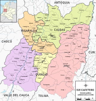
The Colombian coffee region, also known as the Coffee Triangle is a part of the Paisa region in the rural area of Colombia. It is famous for growing and producing the majority of Colombian coffee. There are four departments in the area: Caldas, Quindío, Risaralda and Tolima. The most visited cities are Manizales, Armenia, Pereira, and Ibagué.

Gedeo is a zone in the South Ethiopia Regional State (SERS) of Ethiopia. This zone is named for the Gedeo people, whose homelands lie in this zone. Gedeo is an exclave of the SERS consisting of a narrow strip of land along the eastern escarpment of the Ethiopian Highlands. It is surrounded by the Oromia Region, which borders the Zone on the east, south and west; Gedeo shares its northern boundary with the Sidama Region. Dilla is the administrative center; other towns include Dilla, Wonago, Yirgachefe, Chelelekitu and Gedeb.

The Coastal forests of eastern Africa, also known as the East African Coastal Forests or Zanzibar–Inhambane forests, is a tropical moist forest region along the east coast of Africa. The region was designated a biodiversity hotspot by Conservation International.
Bore is one of the Aanaas in the Oromia of Ethiopia. Part of the Guji Zone, Bore is bordered on the south by Ana Sora, on the west by the Uraga, and on the north and east by the Southern Nations, Nationalities, and Peoples Region. The largest town in Bore is Bore.
Adola is one of the woredas in the Oromia Region of Ethiopia. It is part of former Adolana Wadera woreda what was divided for Adola, Girja and Wadera woredas and Adola town. Part of the Guji Zone, Adolana Wadera was bordered on the south by Liben, on the southwest by Odo Shakiso, on the west by Bore, on the north by the Southern Nations, Nationalities, and Peoples Region, and on the east by the Bale Zone.
Odo Shakiso is one of the Aanaas in the Oromia of Ethiopia. Part of the Guji Zone, Odo Shakiso is bordered on the south by the Dawa River which separates it from Arero, on the west by Bule Hora, on the northeast by Uraga, on the north by Bore, on the northeast by Adolana Wadera, and on the east by Liben. Towns in Odo Shakiso include Shakiso and Megado.
Bule Hora is a woreda in Oromia Region, Ethiopia. It formerly included Dugda Dawa and Kercha districts. Part of the West Guji Zone, Bule Hora was bordered on the south by the Dawa River which separates it from Arero, on the southwest by Yabelo, on the west by the Southern Nations, Nationalities, and Peoples Region and Gelana Abaya, on the northeast by Uraga, and on the east by Odo Shakiso. The largest town of Bule Hora is Bule Hora Town.
Abaya is a woreda in the Oromia Region, Ethiopia. It is part of former Gelana Abaya woreda what was divided for Abaya and Gelana woredas. Part of the Borena Zone, Gelana Abaya was bordered on the south by Hagere Mariam, and on the west, north and east by the Southern Nations, Nationalities, and Peoples Region (SNNPR). Lake Abaya, on the western border, is divided between this woreda and the SNNPR. However, the Guji Oromo who live in Nechisar National Park are claimed to be administratively part of this woreda, in a kebele called "Irgansaa".

Pácora is a town and municipality in the Colombian Department of Caldas. It is located in northern Caldas-Department, on the slopes of the Andes Central Mountains of the Republic of Colombia. With an average annual temperature of 18 °C, the town is bordered to the northeast with Aguadas, Caldas, to the south with Salamina, Caldas and La Merced, and to the west separated by the Cauca River, Marmato-Caldas and Caramanta-Antioquia department. The villages in Pácora are San Bartolomé, Castilla, Las Coles, Los Morros, San Lorenzo and Buenos Aires.

Ensete ventricosum, commonly known as enset or ensete, Ethiopian banana, Abyssinian banana, pseudo-banana, false banana and wild banana, is a species of flowering plant in the banana family Musaceae. The domesticated form of the plant is cultivated only in Ethiopia, where it provides the staple food for approximately 20 million people. The name Ensete ventricosum was first published in the Kew Bulletin 1947, p. 101. Its synonyms include Musa arnoldiana De Wild., Musa ventricosa Welw. and Musa ensete J. F. Gmelin. In its wild form, it is native to the eastern edge of the Great African Plateau, extending northwards from South Africa through Mozambique, Zimbabwe, Malawi, Kenya, Uganda and Tanzania to Ethiopia, and west to the Congo, being found in high-rainfall forests on mountains, and along forested ravines and streams.
The Gedeo are an ethnic group in southern Ethiopia. The Gedeo Zone in the Southern Nations, Nationalities, and People's Region (SNNPR) is named for this people. They speak the Gedeo language, which is one of the Cushitic languages.
The Koore are an ethnic group whose homeland lies in southern Ethiopia. According to Amaro Zone Administration, there are 350,000 members in this group, of whom 8.3% are urban inhabitants.

Wolayita or Wolaita is an administrative zone in Ethiopia. It is named for the Welayta people, whose homeland is in the zone. Wolayita is bordered on the south by Gamo Zone, on the west by the Omo River which separates it from Dawro, on the northwest by Kembata Zone and Tembaro Special Woreda, on the north by Hadiya, on the northeast by the Oromia Region, on the east by the Bilate River which separates it from Sidama Region, and on the south east by the Lake Abaya which separates it from Oromia Region. The administrative centre of Wolayita is Sodo. Other major towns are Areka, Boditi, Tebela, Bale Hawassa, Gesuba, Gununo, Bedessa and Dimtu.

The Honghe Hani Rice Terraces are the system of Hani rice-growing terraces located in Yuanyang County, Honghe Prefecture, Yunnan, China. The terraces' history spans around 1,200 years. The total area stretches across 1,000,000 acres and four counties: Yuanyang, Honghe, Jinpin and Lüchun, although the core area of the terraces is located in Yuanyang County. In 2013, 16,603 hectares of the Honghe Hani Rice Terraces were listed as a World Heritage Site, because of their outstanding resilient construction, unique social-ecological system, and importance to the Hani people.

The Ethiopian montane forests is a tropical moist broadleaf forest ecoregion in eastern Africa. It covers the middle elevations of the Ethiopian Highlands in Ethiopia and extends into neighboring Eritrea, Sudan, Djibouti, and Somaliland. The ecoregion includes distinctive Afromontane forests, woodlands, grasslands, and shrublands. The ecoregion's biodiversity is threatened by deforestation, conversion to agriculture, and overgrazing.

Tiya is an archaeological site in central Ethiopia. It is located in the Soddo woreda, in the Gurage Zone of the Southern Nations, Nationalities, and Peoples Region south of Addis Ababa. It is best known for its archaeological site its large stone pillars, many of which bear some form of decoration. The archeological site was designated a World Heritage Site in 1980, due to the unique nature of these monolithic monuments.
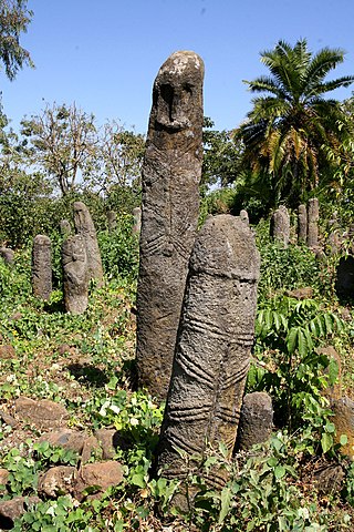
Megaliths in Ethiopia are large, monumental stones, that exist in Ethiopia.
