| Geghashen Գեղաշեն | |
|---|---|
Geghashen | |
 Geghashen | |
| Coordinates: 40°14′04″N44°43′37″E / 40.23444°N 44.72694°E | |
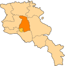
| Country | Armenia |
| Province | Kotayk |
| Population (2011) | |
| • Total | 3,982 |

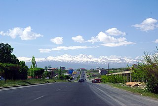
Coordinates: 40°14′04″N44°43′37″E / 40.23444°N 44.72694°E Geghashen (Armenian : Գեղաշեն, until 1935 Chatkran; until 1967 Hrazdan [1] ) is a village in the Kotayk Province of Armenia.

A geographic coordinate system is a coordinate system that enables every location on Earth to be specified by a set of numbers, letters or symbols. The coordinates are often chosen such that one of the numbers represents a vertical position and two or three of the numbers represent a horizontal position; alternatively, a geographic position may be expressed in a combined three-dimensional Cartesian vector. A common choice of coordinates is latitude, longitude and elevation. To specify a location on a plane requires a map projection.
The Armenian language is an Indo-European language spoken primarily by Armenians. It is the official language of Armenia. Historically being spoken throughout the Armenian Highlands, today, Armenian is widely spoken throughout the Armenian diaspora. Armenian is written in its own writing system, the Armenian alphabet, introduced in 405 AD by Mesrop Mashtots.

A village is a clustered human settlement or community, larger than a hamlet but smaller than a town, with a population ranging from a few hundred to a few thousand. Though villages are often located in rural areas, the term urban village is also applied to certain urban neighborhoods. Villages are normally permanent, with fixed dwellings; however, transient villages can occur. Further, the dwellings of a village are fairly close to one another, not scattered broadly over the landscape, as a dispersed settlement.