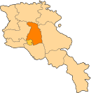
Hrazdan, is a town and urban municipal community in Armenia serving as the administrative centre of Kotayk Province, located 45 kilometres northeast of the capital Yerevan. As of the 2011 census, the population of the town is 41,875. It has lost a significant number of inhabitants since the 1989 census reported 59,000 people.

Tsaghkadzor, is a spa town and urban municipal community, as well as one of the most popular health resorts in Armenia, located north of the capital Yerevan in the Kotayk Province. According to the 2011 census, the town has a population of 1,256, down from 3,350 reported in the 1989 census. Currently, the town has an approximate population of 900 as per the 2016 official estimate.

Abovyan or Abovian, is a town and urban municipal community in Armenia within the Kotayk Province. It is located 16 kilometres northeast of Yerevan and 32 kilometres southeast of the province centre Hrazdan. As of the 2011 census, the population of the town is 43,495, down from 59,000 reported at the 1989 census. Currently, the town has an approximate population of 35,400 as per the 2016 official estimate.

Byureghavan, is a town and urban municipal community in the Kotayk Province of Armenia. It is located 16 kilometres northeast of Yerevan, and 25 kilometres south of the provincial center Hrazdan. It covers an area of 4 square kilometres. The rural communities of Nurnus and Arzni form the northern and southern borders of the town respectively. As of the 2011 census, the population of the town is 9,513. Currently, the town has an approximate population of 8,300 as per the 2016 official estimate.
Mikhaylovka or Mikhailovka may refer to:

Alapars is a village in the Kotayk Province of Armenia. The village has 860 dwellings, a school, house of culture, and library. The population is entirely Armenian. Notable natives are director of pump station of the Alapars, USSR multiple medalist Avetik Avetyan, Patriarch Mushegh Aliabertsi (490-561), artist Tatik Saryan, dramatist Melik Kocharyan, folk collector Shavigh Grigoryan, The statesman of RA, Governor of Kotayk Republic of Armenia Kavalenko Shahgaldyan.

Arzni, is a resort village in the Kotayk Province of Armenia located on in the Hrazdan canyon. It was founded during the 19th century by Assyrian Christians who migrated to Eastern Armenia from Iran. The village is predominantly inhabited by Assyrians.

Meghradzor, meaning, valley of honey; formerly known as Taycharukh), is a village in the Kotayk Province of Armenia, 15 kilometres (9 mi) northwest of Hrazdan. The village is located to the south of the Tsaghkunyats mountain range, along the left bank of the Marmarik River. It was founded my immigrants from Aratsap in 1830 and is well known for its famous honey, hence, the name Meghradzor literally translates to valley of honey. The nearby village of Gorgoch is also included in the community of Meghradzor.
Akunk is a village in the Kotayk Province of Armenia, located 6 km northeast of Abovyan and situated at the foot of Mount Hatis. The village was founded in 1829 by Armenian immigrants from Persia and Western Armenia, while the current population is Armenian and Kurdish. The local economy is heavily dependent on agriculture, based primarily on grain farming, orchard cultivation, and cattle-breeding. Akunk has a school, house of culture, library, and east of the village is a shrine of Poghos-Petros of the Late Middle Ages. A cyclopean fortress is also nearby.
Argel, is a village in the Kotayk Province of Armenia.
Balahovit is a village in the Kotayk Province of Armenia. The majority of the early settlers of the village immigrated in 1828-29 from Khoy and Salmast in present-day Iran, while some of the immigrants came from Bulankh. It was renamed Balahovit in 1968 at the request of an Armenian-American group, after one of the eight cantons (gavar) of Sophene in Greater Armenia, of the same name. The community has a school, house of culture, and a first aid station, as well as the site of Yerevan Veterinary Institute's experimental station. Balahovit had a kindergarten, but it was closed in July 2004 due to the deteriorating conditions of the educational facility. The local economy is heavily dependent on agriculture, based primarily on grain farming, orchard cultivation, and cattle-breeding.
Buzhakan, also Romanized as Bujhakan; formerly, Babakishi), is a village in the Kotayk Province of Armenia. It is situated along the eastern foothills of the Tsaghkunyats mountain range, upon a fertile slope. Early settlers of the village began immigrating to the area in 1829 from Bitlis, Artsap, Alashkert, Mush, Sasun, and Khoy. The community has a school, kindergarten, and a library. In a wooded area to the north of Buzhakan is the well-known 10th-14th century Teghenyats Monastery, and to the east of the village are the ruins of a 6th-7th century church.

Goght is a village in the Kotayk Province of Armenia, located on the right bank of the upper-Azat River. It is known from 13th-century manuscripts as Goghot. It is located near Garni and sits along the road leading to Geghard Monastery. The village has a small ruined basilica from the 17th or 18th century located straight down a dirt road from the main square. Some khachkars are built into the exterior walls of the church, as well as at its altar. Goght sits overlooking a large gorge and upon a promontory on the other side is the 11th- to 13th-century monastery of Havuts Tar. It may be reached by foot from the town, but more easily from Garni via the Garni Gorge. The community has a school, kindergarten, house of culture, and a library. The local economy is heavily dependent on agriculture, based primarily on grain farming, orchard cultivation, and cattle-breeding.

Kaputan, is a village in the Kotayk Province of Armenia.
Lernanist is a town in the Kotayk Province of Armenia. It is home to the descendants of Armenian settlers from Van who survived the Armenian Genocide.
Mrgashen is a village in the Kotayk Province of Armenia. It is located along the left bank of the Arzni-Shamiram aqueduct. Mrgashen was officially founded in March 1960 around the state-owned collective farm or sovkhoz No. 6. The local economy is highly dependent on agriculture, based primarily on orchard cultivation and pig or cattle-breeding. The community currently has a school, kindergarten, house of culture, medical station, and a library. 60% of households receive natural gas and drinking water for the village comes from the Arzakan-Yerevan network, while water for irrigation comes from the Arzni-Shamiram aqueduct.

Zoravan is a village situated along the lower slopes of Mount Ara in the Kotayk Province of Armenia. The village was established in 1972-80, during which time it was called Pokravan, for the purpose of developing a large stockyard or feedlot that would ultimately be utilized to breed a target of eleven-thousand animals. After reaching capacity, the village was renamed to Zoravan after the nearby Zoravar Church, also known as Gharghavank, built between 661 and 685 by Prince Grigor Mamikonian. The community currently has a school and a kindergarten. Drinking water for the village comes from a source near Karenis, while water for irrigation comes from Lake Sevan.

Zovuni, is an abandoned village in the Aragatsotn Province of Armenia. It was formed during the 1828 by Armenian migrants from the village of Akori in Western Armenia. The villages was abandoned in 1965 and its ruins now lie beneath the Aparan Reservoir.