The Zuckerhütl is a mountain in Tyrol, Austria. At 3,505 metres, it is the highest peak of the Stubai Alps and lies at the southern end of the Stubaital Valley.

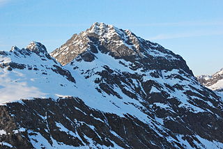
The Bellecôte is a mountain in the Vanoise Massif in the Graian Alps, lying in the northern part of the Vanoise National Park and dominating the Peisey-Nancroix valley in Savoie. The north face is immense and austere, whereas the south face is more accessible.

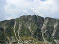
Prisojnik or Prisank is a mountain of the Julian Alps in Slovenia. Its summit is 2,547m above sea level. It is located above the Vršič Pass, from where most climbs of the mountain start.
Monte Sernio is a remote mountain of the Carnic Alps, in Udine, northeast Italy, with an elevation of 2,187 m. It is located, together with the nearby Creta Grauzaria, in the mountain chain between the Incarojo Valley, near the village of Paularo, and the Aupa Valley. It was first climbed in 1879 by sisters Minetta and Annina Grassi.

The Latemar is a mountain in the Dolomites on the border between South Tyrol and Trentino, Italy. It is the westernmost mountain of the Dolomites and is a popular hiking destination. It is best known for its view from the Karersee lake.

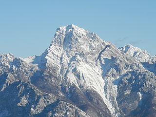
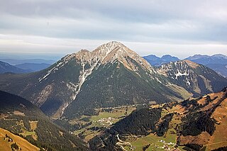
The Hochgolling is a mountain of the Eastern Alps, located on the border of Steiermark and Salzburg, Austria, near the ski resort of Schladming. It is the highest peak of the Lower Tauern range.

The Hochalmspitze is, at 3,360 metres above the Adriatic (11,020 ft), the highest mountain of the Ankogel Group in the High Tauern range, located east of Mallnitz in the Austrian state of Carinthia. It is sometimes called "Tauern Queen" as a counterpart to the "Tauern King", the Grossglockner.
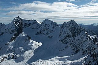
Petzeck (3,283m) is the highest mountain of the Schober Group in the High Tauern range, Austria. The mountain has a 1,000m high north face but its southern slope is more gentle, with lakes such as Kreuzsee and Wangenitzsee on its slopes. Its south western slope is glaciated.

The Großer Muntanitz (3,232m) is the highest mountain in the Granatspitze Group, located between the Venediger Group and the Glockner Group in the High Tauern, Austria.

Hocharn (3,254m) is the highest mountain of the Goldberg Group in the High Tauern range of the eastern Alps. It is located near the town of Bad Hofgastein and is situated in the Austrian state of Salzburg.

Großer Hafner is a 3,076 m (10,092 ft) high partly-glaciated mountain of the Ankogel Group in the High Tauern range, located at the border between the Austrian states of Carinthia and Salzburg. It is the easternmost three-thousander peak of the range, and also in the entire Alps.

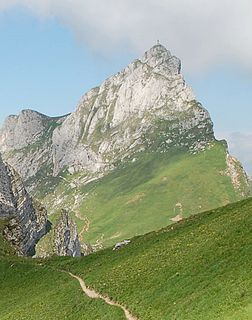
Trogkofel is a mountain of the Carnic Alps lying on the border of Friuli, Italy and Carinthia, Austria. It is located on the main ridge of the Carnics between the Aip Valley to the south and the Gail Valley in the north, and is the second highest mountain on the eastern ridge after Gailtaler Polinik. The mountain is known as Crete Rosse, meaning Red Rocky Mountain in Friuli.
Hochiss is a mountain in Tyrol, Austria. Rising some 2,299 metres (7,543 ft), it is the highest mountain of the Brandenberg Alps and is located near the tourist hot spot Achensee. Its steep north face is popular with rock climbers and its other slopes are a popular destination for hiking and paragliding as well as snowshoeing and ski touring in the winter.
Thaneller is a mountain of the Lechtal Alps, a sub-range of the Northern Limestone Alps in Tyrol, Austria. It is a prominent, free standing pyramidal peak located near Ehrwald, on the northwestern edge of the Lechtals. Due to its prominence and the gentle nature of its southern slopes, it is a very popular mountain for hikers, with a good panorama from its summit, which reaches from the lowlands in the North to the Main chain of the Alps in the South. Wildspitze is the highest mountain that can be seen on a clear day.

Cima Bocche is a mountain of the Dolomites in Trentino, Italy. It is the highest peak of a small group that is located between the San Pellegrino Pass and the Predazzo valley. The mountain boasts a vertical 400m north face, whereas its southern slopes are far more gentle, making it an easy climb from this direction. Despite being geographically part of the Dolomites, the mountain is not geologically part of the range, as it is formed of Porphyry rather than Dolomite.
Vallüla is a mountain of the Silvretta Alps on the border between Tyrol and Vorarlberg, Austria. It is located above the Bielerhöhe pass, from where most climbs start from.

The Reißkofel is, at 2,371 metres above the Adriatic (7,779 ft), the highest mountain of the Gailtal Alps east of the Lienz Dolomites. It is situated in the centre of the Gailtal range, part of the Southern Limestone Alps, in the Austrian state of Carinthia.

Latschur, at 2,236 m (7,336 ft), is the highest mountain of the Latschur Group in the Gailtal Alps range, in the Austrian state of Carinthia.

Großer Bösenstein is a mountain of the Lower Tauern in Styria, Austria. It is located near the village of Hohentauern, which is the starting point for most climbs, and is the third highest mountain of the Rottenmann and Wölz Tauern sub-range. It is a hiking peak, and the view from the summit provides an excellent view of the far Eastern Alps, including Grimming and the Totes Gebirge.