Geldrop

Last updated
Geldrop, Netherlands
Town and former municipality
Kasteel Geldrop.jpg
2010-NL-P10-Noord-Brabant-positiekaart-gemnamen.jpg
Red pog.svg
Geldrop, Netherlands
Location in the province of North Brabant in the Netherlands
Netherlands location map.svg
Red pog.svg
Geldrop, Netherlands
Geldrop, Netherlands (Netherlands)
Coordinates: 51°25′20″N5°33′28″E / 51.42222°N 5.55778°E / 51.42222; 5.55778
Country Netherlands
Province North Brabant
Municipality Geldrop-Mierlo
Area
[1]
  Total13.36 km2 (5.16 sq mi)
Elevation
[2]
21 m (69 ft)
Population
 (2023) [1]
  Total29,245
  Density2,200/km2 (5,700/sq mi)
Time zone UTC+1 (CET)
  Summer (DST) UTC+2 (CEST)
Postal code
5660-5667 [1]
Dialing code 040

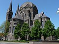
Geldrop is a town in the Dutch province of North Brabant. It is in the municipality of Geldrop-Mierlo, around 5km east of Eindhoven's city centre. Geldrop was a separate municipality until 2004, when it merged with Mierlo. [3]

Contents

As of 2023, Geldrop has a population of approximately 29.245 residents. [4]

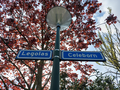
Geldrop is noted for having a neighbourhood with streets named after characters and elements from the works of J. R. R. Tolkien. [5] [6] [7]

Geography

Geldrop is situated near the city of Eindhoven, making it part of the Eindhoven metropolitan area. The village is characterized by its picturesque settings, surrounded by natural landscapes including forests and meadows which are part of the larger Strabrechtse Heide, an extensive heathland area.

The A67 motorway (part of European route E34) links Geldrop with Eindhoven.

Geldrop railway station is on the Eindhoven–Weert line.

History

Geldrop has proven a fertile ground for archaeological digs, with finds from various historical and prehistorical eras. Through the years, several archaeological finds were made which testify to prehistoric occupants.

Finds in the south of Zesgehuchten (a district of Geldrop) indicate small settlements from the New Stone Age (about 3000 BC).

Finds from the Roman Period and the early Middle Ages have been found off Genoenhuis and Hoog Geldrop (districts in Geldrop). In the autumn of 1989, archaeological diggings at the nearby 't Zand Cemetery found four settlements from the late Roman Period and the Middle Ages: a period which covers the years between 350 and 1225 AD.

The history of Geldrop itself dates back to the Middle Ages, and it was first mentioned in historical records in 1296. Over the centuries, it developed from a small agricultural community into a more industrially oriented village by the 19th century, with textiles becoming a significant industry.

Economy

While historically reliant on the textile industry, modern Geldrop has diversified its economy. Today, it hosts a variety of businesses and services, with significant contributions from the healthcare, retail, and manufacturing sectors. Geldrop benefits economically from its close proximity to the technological and industrial hub of Eindhoven.

Famous people from Geldrop

Related Research Articles

<span class="mw-page-title-main">America, Netherlands</span> Village in Limburg, Netherlands

America is a parish village in the Dutch province of Limburg, known historically for its peat extraction.

<span class="mw-page-title-main">Helmond</span> City in North Brabant, Netherlands

Helmond is a city and municipality in the Metropoolregio Eindhoven of the province of North Brabant in the Southern Netherlands.

<span class="mw-page-title-main">Kapelle</span> Municipality in Zeeland, Netherlands

Kapelle is a municipality and a town in the southwestern Netherlands on Zuid-Beveland. In 2023 the municipality's population amounts to 13,051.

<span class="mw-page-title-main">Rozendaal</span> Municipality in Gelderland, Netherlands

Rozendaal is a municipality and a town in the eastern Netherlands, in the province of Gelderland. The town, next to Arnhem and Velp, is known for the Rozendaal Castle and its water fountain follies (bedriegertjes).

<span class="mw-page-title-main">Geldrop-Mierlo</span> Municipality in North Brabant, Netherlands

Geldrop-Mierlo is a municipality in the southern Netherlands, in the province of North Brabant. The municipality was created from the two former municipalities of Geldrop and Mierlo on 1 January 2004.

<span class="mw-page-title-main">Mierlo</span> Town in North Brabant, Netherlands

Mierlo is a village in the southern Netherlands, in the municipality of Geldrop-Mierlo, North Brabant. Until 2004, it was a separate municipality with an area of 18.09 km2 (7 sq mi).

<span class="mw-page-title-main">Aldtsjerk</span> Village in Friesland, Netherlands

Aldtsjerk is a village on the main road from Leeuwarden to Dokkum. It is part of Tytsjerksteradiel municipality, Friesland, the Netherlands and had around 615 inhabitants as of January 2018.

<span class="mw-page-title-main">Mijdrecht</span> Place in Utrecht, Netherlands

Mijdrecht is a town in the Netherlands with about 16,000 residents. It is located in the municipality of De Ronde Venen, about 7 kilometres (4.3 mi) west of the main A2 motorway, between Utrecht and Amsterdam.

<span class="mw-page-title-main">Koudum</span> Village in Friesland, Netherlands

Koudum is a village in the northern Netherlands. It is located in Súdwest-Fryslân, Friesland. Nearby villages include Molkwerum to the west, Workum to the north and Hemelum to the south. The population of Koudum was 2,700 in 2019. The nearest train station is the Koudum-Molkwerum railway station.

Jipsingboertange is a hamlet in the Dutch province of Groningen. It is a part of the municipality of Westerwolde, and lies about 25 km northeast of Emmen. In 2021, the village of Jipsingboertange had 175 inhabitants. The postal authority does not consider the village a separate entity and has placed it under Sellingen.

<span class="mw-page-title-main">Zegge</span> Village in North Brabant, Netherlands

Zegge is a village located in the municipality of Rucphen, North Brabant in the Netherlands. On 1 January 2020, the village had 2,045 inhabitants. Viewed from the four other villages in the municipality of Rucphen, Zegge is located on the other side of the A58 motorway. This combined with its small size, makes it so that much of the daily life of its inhabitants centers around the nearby city of Roosendaal.

<span class="mw-page-title-main">Amby, Maastricht</span> Neighbourhood & former municipality in Netherlands, Limburg, Maastricht

A former village, Amby is now a neighborhood of Maastricht, in the Netherlands, located about 4 km northeast of the center of the city.

<span class="mw-page-title-main">Beek, Berg en Dal</span> Village in Gelderland, Netherlands

Beek is a village in the Dutch province of Gelderland. It is located in the municipality of Berg en Dal, about 5 km east of Nijmegen. It was sometimes referred to as "Beek " or "Beek-Ubbergen" because there are many villages called Beek.

<span class="mw-page-title-main">Lomm</span> Dorp in Limburg, Netherlands

Lomm is a small village in the municipality of Venlo, the Netherlands, seven kilometres to the north of Venlo. There were 1,035 inhabitants in 2021.

<span class="mw-page-title-main">Leende</span> Village in North Brabant, Netherlands

Leende is a village in the Dutch province of North Brabant. It is located in the municipality of Heeze-Leende, approximately 12 km southeast of Eindhoven.

Hatert is a suburb in the south of Nijmegen, in the Netherlands. As of 2021 it has a population of 10.115.

<span class="mw-page-title-main">Westmaas</span> Village in South Holland, Netherlands

Westmaas is a village in the Dutch province of South Holland. It is located about 14 km south of the city of Rotterdam, next to Mijnsheerenland in the municipality of Hoeksche Waard. In 2020, the population was 2065.

<span class="mw-page-title-main">Finsterwolde</span> Village in Groningen, Netherlands

Finsterwolde is a village in the Dutch province of Groningen, about 7 km northeast of the city of Winschoten. Finsterwolde was a separate municipality until 1990, when it was merged with Beerta into Reiderland. In 2010 Reiderland merged into the municipality Oldambt. The old municipality of Finsterwolde included six small nearby or connecting settlements. These are also taken into account in the population estimate of 2008, without which the actual population, purely based on the centre and new developments, would be 1250. The village is known for the Galery Waalkens.

<span class="mw-page-title-main">Soerendonk</span> Village in North Brabant, Netherlands

Soerendonk is a village in the Dutch province of North Brabant. It is located in the municipality of Cranendonck. The former Cranendonck Castle used to be located in the village. It is located about 17 kilometres (11 mi) south-south-east of Eindhoven.

<span class="mw-page-title-main">Schilberg, Echt-Susteren</span> Neighborhood in the Dutch Limburgish village of Pey

Schilberg is a neighborhood in the Dutch Limburgish village of Echt. It is home to Our Lady of Schilberg, a chapel and pilgrimage site. It was home to 1,870 people in 2021.

References

  1. 1 2 3 "Kerncijfers wijken en buurten 2023". Central Bureau of Statistics. Retrieved 18 April 2024.
  2. "Postcodetool for 5661AA". Actueel Hoogtebestand Nederland (in Dutch). Het Waterschapshuis. Retrieved 16 April 2022.
  3. Ad van der Meer and Onno Boonstra, Repertorium van Nederlandse gemeenten , KNAW, 2011.
  4. Statistiek, Centraal Bureau voor de (2024-03-14). "Kerncijfers wijken en buurten 2023". Centraal Bureau voor de Statistiek (in Dutch). Retrieved 2024-04-18.
  5. Strutner, Sizy. "Every Street In This Dutch Neighborhood Has A Lord Of The Rings Name, Which Is Awesome". The Huffington Post . Retrieved 26 January 2014.
  6. Wedia. "The streets in this Dutch neighbourhood are named after Lord of the Rings!". IamExpat. Retrieved 2023-08-10.
  7. "Saruman is onttoverd". NRC (in Dutch). 2023-03-15. Retrieved 2023-08-10.