Gendema

Last updated
Gendema
Sierra Leone adm location map.svg
Red pog.svg
Gendema
Location in Sierra Leone
Coordinates: 7°21′2″N11°43′5″W / 7.35056°N 11.71806°W / 7.35056; -11.71806 Coordinates: 7°21′2″N11°43′5″W / 7.35056°N 11.71806°W / 7.35056; -11.71806
Country Flag of Sierra Leone.svg Sierra Leone
Province Southern Province
District Pujehun District
Chiefdom Soro Gbema Chiefdom
Time zone GMT (UTC-5)

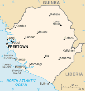
Gendema is a rural town in Pujehun District in the Southern Province of Sierra Leone. Gendema lies in the far Southern part of Sierra Leone, on the international border with the Republic of Liberia. [1] [2] [3]

Pujehun District Place in Southern Province, Sierra Leone

Pujehun District is a district in the Southern Province of Sierra Leone. Its capital is the town of Pujehun. The other major towns in the district include Gandorhun, Zimmi, Gendema, Masam, Bomi and Potoru. As of 2015, the district has a population of 345,577. The population of Pujehun District is largely from the Mende ethnic group; and the district is predominantly Muslim.

Southern Province, Sierra Leone Place in Sierra Leone

The Southern Province is one of the four provinces of Sierra Leone. It covers an area of 19,694 km² and has a population of 1,438,572. It consists of four districts. Its capital and administrative center is Bo, which is also the second largest and second most populated city in Sierra Leone after the nation's capital Freetown. The population of the southern province is largely from the Mende ethnic group.

Sierra Leone republic in West Africa

Sierra Leone, officially the Republic of Sierra Leone, informally Salone, is a country on the southwest coast of West Africa. It has a tropical climate, with a diverse environment ranging from savanna to rainforests. The country has a total area of 71,740 km2 (27,699 sq mi) and a population of 7,075,641 as of the 2015 census. Sierra Leone is a constitutional republic with a directly elected president and a unicameral legislature. The country's capital and largest city is Freetown. Sierra Leone is made up of five administrative regions: the Northern Province, North West Province, Eastern Province, Southern Province and the Western Area. These regions are subdivided into sixteen districts.

Gendema is the chieftaincy seat of Soro Gbema Chiefdom [3] and is a trading center between Sierra Leoneans and Liberians across the border. The principal inhabitants of gendema are the Mende, Vai and Kissi people.

Soro Gbema is a chiefdom in Pujehun District of Sierra Leone with a population of 31,977. Its principal town is Fairo.

Mende people ethnic group

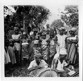
The Mende people are one of the two largest ethnic groups in Sierra Leone; their neighbours, the Temne people, have roughly the same population. The Mende and Temne each account for slightly more than 30% of the total population. The Mende are predominantly found in the Southern Province and the Eastern Province, while the Temne are found primarily in the Northern Province and the Western Area, including the capital city of Freetown. Some of the major cities with significant Mende populations include Bo, Kenema, Kailahun, and Moyamba.

Vai people

The Vai are a Manden ethnic group that live mostly in Liberia, with a small minority living in south-eastern Sierra Leone. The Vai are known for their indigenous syllabic writing system known as Vai syllabary, developed in the 1820s by Momolu Duwalu Bukele and other tribal elders. Over the course of the 19th century, literacy in the writing system became widespread. Its use declined over the 20th century, but modern computer technology may enable a revival.

Related Research Articles

Geography of Guinea

Guinea is a country on the coast of West Africa and is bordered by Guinea-Bissau, Senegal, Mali, Ivory Coast, Liberia, and Sierra Leone.

Geography of Sierra Leone

Sierra Leone is located on the west coast of Africa, between the 7th and 10th parallels north of the equator. Sierra Leone is bordered by Guinea to the north and northeast, Liberia to the south and southeast, and the Atlantic Ocean to the west.

Charles Taylor (Liberian politician) Liberian former politician who was the 22nd President of Liberia

Charles McArthur Ghankay Taylor is a Liberian war criminal and former politician who served as the 22nd President of Liberia from 2 August 1997 until his resignation on 11 August 2003.

Mano River river in west Africa

The Mano River is a river in West Africa. It originates in the Guinea Highlands in Liberia and forms part of the Liberia-Sierra Leone border.

Sierra Leone Civil War civil war between Commonwealth-backed government and rebel factions

The Sierra Leone Civil War (1991–2002) began on 23 March 1991 when the Revolutionary United Front (RUF), with support from the special forces of Charles Taylor’s National Patriotic Front of Liberia (NPFL), intervened in Sierra Leone in an attempt to overthrow the Joseph Momoh government. The resulting civil war lasted 11 years, enveloped the country, and left over 50,000 dead.

The Guinean forests of West Africa is a biodiversity hotspot designated by Conservation International, which includes the belt of tropical moist broadleaf forests along the coast of West Africa, running from Sierra Leone and Guinea in the west to the Sanaga River of Cameroon in the east. The Dahomey Gap, a region of savanna and dry forest in Togo and Benin, divides the Guinean forests into the Upper Guinean forests and Lower Guinean forests.

The Back-to-Africa movement, also known as the Colonization movement or After slave act, originated in the United States during the 19th century. It encouraged those of African descent to return to the African homelands of their ancestors. This movement would eventually inspire other movements, ranging from the Nation of Islam to the Rastafari movement and proved to be popular among African Americans.

Moa River river in west Africa

The Moa River is a river in west Africa. It arises in the highlands of Guinea and flows southwest, forming parts of the Guinea–Liberia and the Guinea – Sierra Leone borders. It flows into the Southern Province of Sierra Leone. Yenga, Tiwai Island and Sulima are located on the Moa.

United Nations Security Council Resolution 1231 United Nations Security Council resolution

United Nations Security Council resolution 1231, adopted unanimously on 11 March 1999, after recalling resolutions 1181 (1998) and 1220 (1999) on the situation in Sierra Leone, the Council extended the mandate of the United Nations Observer Mission in Sierra Leone (UNOMSIL) until 13 June 1999.

United Nations Security Council Resolution 1408 United Nations Security Council resolution

United Nations Security Council resolution 1408, adopted unanimously on 6 May 2002, after recalling resolutions 1132 (1997), 1171 (1998), 1306 (2000), 1343 (2001), 1385 (2001), 1395 (2002) and 1400 (2002) on the situation in Sierra Leone, the Council extended sanctions against Liberia for its support of rebels in the civil war in Sierra Leone.

United Nations Security Council Resolution 1508 United Nations Security Council resolution

United Nations Security Council resolution 1508, adopted unanimously on 19 September 2003, after recalling all previous resolutions on the situation in Sierra Leone, the Council extended the mandate of the United Nations Mission in Sierra Leone (UNAMSIL) for six months until 31 March 2004.

Liberia–Sierra Leone relations Diplomatic relations between the Republic of Liberia and the Republic of Sierra Leone

Liberia – Sierra Leone relations refers to the historical and current relationship between Liberia and Sierra Leone. The two countries signed a non-aggression pact in 2007 when Sierra Leonean President Ernest Bai Koroma took office. In January 2011, an African diplomat described relations as "cordial".

Guéckédou Sub-prefecture and town in Nzérékoré Region, Guinea

Guéckédou or Guékédou is a town in southern Guinea near the Sierra Leone and Liberian borders. It had a population of 79,140 in 1996 (census) but has grown massively since the civil wars and, as of 2008, it is estimated to be 221,715. It was a centre of fighting during the Second Liberian Civil War and the Sierra Leone Civil War in 2000 and 2001.

<i>Mylothris chloris</i> species of insect

Mylothris chloris, the western dotted border or common dotted border, is a butterfly in the family Pieridae. It is found in Senegal, the Gambia, Mali, Guinea-Bissau, Guinea, Sierra Leone, Liberia, Ivory Coast, Burkina Faso, Ghana, Togo, Benin, Nigeria, Cameroon, Equatorial Guinea, Gabon, the Republic of the Congo, the Central African Republic, the Democratic Republic of the Congo, Sudan, Uganda, Kenya and Tanzania. The habitat consists of open woodland and dense savanna, but may also be found in disturbed rainforest areas and suburban gardens.

Ethnic groups in Sierra Leone

Sierra Leone is home to about sixteen ethnic groups, each with its own language. In Sierra Leone, membership of an ethnic group often overlaps with a shared religious identity.

The following lists events that happened during 2014 in Sierra Leone.

Fatima Massaquoi pioneering educator in Liberia

Fatima Massaquoi-Fahnbulleh was an educator in Liberia, West Africa. After completing her education in the United States, she returned to Liberia in 1946, where she contributed much to the cultural and social life of the country.

References

  1. "Travelogue On the road to Liberia Border- the Good, bad and ugly". Awako. Retrieved 18 May 2013.
  2. "Lubbers hails return movements in West Africa". Relief Web. 3 February 2005.
  3. 1 2 Bundu, Bampia (2 March 2012). "In Gendema… SLPP Members Were Beaten". Africa Young Voices. Archived from the original on 2012-03-17.