
Walworth County is a county located in the U.S. state of Wisconsin. As of the 2020 census, the population was 106,478. Its county seat is Elkhorn. The county was created in 1836 from Wisconsin Territory and organized in 1839. It is named for Reuben H. Walworth. Walworth County comprises the Whitewater-Elkhorn, WI Micropolitan Statistical Area and is included in the Milwaukee-Racine-Waukesha, WI Combined Statistical Area. Lake Geneva, the University of Wisconsin-Whitewater, and Alpine Valley Resort, and Music Theatre are located in Walworth County.

Jefferson County is one of the 36 counties in the U.S. state of Oregon. At the 2020 census, the population was 24,502. The county seat is Madras. The county is named after Mount Jefferson.

Shaniko is a city located in Wasco County, Oregon, United States, on U.S. Route 97 and about 8 miles (13 km) north of Antelope. The population was 30 at the 2020 census.
Idiotville is a ghost town in Tillamook County, Oregon, United States, near the mouth of Idiot Creek on the Wilson River, on the route of Oregon Route 6. Idiotville's elevation is 1,200 feet.
Takilma is an unincorporated community and census-designated place (CDP) in Josephine County, Oregon, United States, 10 miles (16 km) south of Cave Junction. It is located on the East Fork Illinois River, about a mile southeast of the ghost town of Waldo. As of the 2010 census, it had a population of 378.

Oregon City, formerly Bloomingdale and Hengy, is a ghost town located between Oroville and Cherokee in Butte County, California. One of the first mining camps in the county, it was established in the autumn of 1848 by a party of Oregonians, who came to California over the Applegate and Lassen trails. Little more than a year later their captain, Peter H. Burnett, became the first civil Governor of California. For a time, Oregon City prospered as a gold mining and supply center, then it declined into virtual oblivion. It lies 1,184 feet (361 m) above mean sea level.

Whitney is an unincorporated community, also considered a ghost town, in Baker County, Oregon, United States, on Oregon Route 7 southwest of Sumpter. It is on the North Fork Burnt River, near the Blue Mountains and Wallowa-Whitman National Forest.

Ashwood is a ghost town in Jefferson County, Oregon, United States, 32 miles (51 km) northeast of Madras.

Wendling is an unincorporated community in Lane County, Oregon, United States, located northeast of Marcola. Wendling's post office operated from 1899 to 1952. It was named for George X. Wendling, a local lumberman. Wendling was created as a company town for the Booth-Kelly Lumber Company.
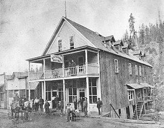
Auburn was an unincorporated community in rural Baker County, Oregon, United States, now considered a ghost town. Auburn lies off Oregon Route 7 southwest of Baker City and east of McEwen on the edge of the Blue Mountains.
Bourne is a ghost town in Baker County, Oregon, United States about 7 miles (11 km) north of Sumpter in the Blue Mountains. It lies on Cracker Creek and is within the Wallowa–Whitman National Forest. Platted in 1902, the former gold mining boomtown is considered a ghost town today.
Clifton is an unincorporated community in Clatsop County, Oregon, United States. It is located north of U.S. Route 30, about nine miles northwest of Westport on the south bank of the Columbia River. It is on Clifton Channel across from Tenasillahe Island.
There are a number of widely reported haunted locations in the state of Oregon in the United States. Many reported hauntings in Oregon are linked to such historic places as the Oregon Trail and early coastal communities. Portland, the state's largest city and metropolitan area, was considered one of the most dangerous port cities in the world at the turn of the 20th century. Its gritty history includes many locations alleged or reported to be haunted. In 2012, USA Today named Portland among the top ten most haunted cities in the United States.

Jawbone Flats is a ghost town in Marion County, Oregon, United States. It is located along Opal Creek, approximately 22 miles (35 km) from Salem, the state capitol, and is accessible via the Opal Pool Loop trail. Established in 1931, Jawbone Flats was a mining camp founded after miners discovered gold in the region in 1859.
Miller is a former community in Sherman County, Oregon, United States, established circa 1860. It was named for Thomas Jefferson Miller, a settler of the area, also for which Miller Island on the Columbia River takes its name. Miller is contemporarily considered a ghost town.


