Related Research Articles

Long Valley Caldera is a depression in eastern California that is adjacent to Mammoth Mountain. The valley is one of the Earth's largest calderas, measuring about 20 mi (32 km) long (east-west), 11 mi (18 km) wide (north-south), and up to 3,000 ft (910 m) deep.

Mono County is a county located in the east central portion of the U.S. state of California. As of the 2020 census, the population was 13,195, making it the fourth-least populous county in California. The county seat is Bridgeport. The county is located east of the Sierra Nevada between Yosemite National Park and Nevada. The only incorporated town in the county is Mammoth Lakes, which is located at the foot of Mammoth Mountain. Other locations, such as June Lake, are also famous as skiing and fishing resorts. Located in the middle of the county is Mono Lake, a vital habitat for millions of migratory and nesting birds. The lake is located in a wild natural setting, with pinnacles of tufa arising out of the salty and alkaline lake. Also located in Mono County is Bodie, the official state gold rush ghost town, which is now a California State Historic Park.

Mammoth Lakes is a town in Mono County, California, and is the county's only incorporated community. It is located immediately to the east of Mammoth Mountain, at an elevation of 7,880 feet (2,400 m). As of the 2020 United States Census, the population was 7,191, reflecting a 12.7% decrease from the 2010 Census.

Mammoth Mountain is a lava dome complex partially located within the town of Mammoth Lakes, California, in the Inyo National Forest of Madera and Mono Counties. It is home to a large ski area primarily on the Mono County side.

Owens Valley is an arid valley of the Owens River in eastern California in the United States. It is located to the east of the Sierra Nevada, west of the White Mountains and Inyo Mountains, and north of the Mojave Desert. It sits on the west edge of the Great Basin. The mountain peaks on the West side reach above 14,000 feet (4,300 m) in elevation, while the floor of the Owens Valley is about 4,000 feet (1,200 m), making the valley the deepest in the United States. The Sierra Nevada casts the valley in a rain shadow, which makes Owens Valley "the Land of Little Rain." The bed of Owens Lake, now a predominantly dry endorheic alkali flat, sits on the southern end of the valley.
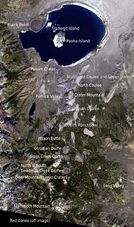
The Mono–Inyo Craters are a volcanic chain of craters, domes and lava flows in Mono County, Eastern California. The chain stretches 25 miles (40 km) from the northwest shore of Mono Lake to the south of Mammoth Mountain. The Mono Lake Volcanic Field forms the northernmost part of the chain and consists of two volcanic islands in the lake and one cinder cone volcano on its northwest shore. Most of the Mono Craters, which make up the bulk of the northern part of the Mono–Inyo chain, are phreatic volcanoes that have since been either plugged or over-topped by rhyolite domes and lava flows. The Inyo volcanic chain form much of the southern part of the chain and consist of phreatic explosion pits, and rhyolitic lava flows and domes. The southernmost part of the chain consists of fumaroles and explosion pits on Mammoth Mountain and a set of cinder cones south of the mountain; the latter are called the Red Cones.

Tioga Pass, at an elevation of 9,945 ft (3,031 m), is a mountain pass in the Sierra Nevada of California. State Route 120 runs through it, and serves as the eastern entry point for Yosemite National Park, at the Tioga Pass Entrance Station. It is the highest highway pass in California and in the Sierra Nevada. Mount Dana is to the east of the pass, and Gaylor Peak to the west. There are several trailheads into the Yosemite backcountry which begin at Tioga Pass, including the trail to the Gaylor Lakes to the west/northwest, and the rough trail to the summit of Mount Dana. Dana Meadows is immediately south of the pass alongside the highway, as the pass itself is roughly angled north–south as opposed to east–west. Dana Meadows contains several small lakes.

The following is a bibliography of the Sierra Nevada of California, United States, including books on recreation, natural history, and human history.

Convict Lake is a lake located in Mono County, California, United States, situated in the Sherwin Range of the Sierra Nevada. It is known for its turquoise-blue water, the dramatic mountains that surround it, the trout fishing it affords, and its unusual history. The lake was renamed from its traditional Mono name by American settlers after an incident on September 23, 1871, in which a group of convicts escaped from prison in Carson City, Nevada, and took refuge near the lake. They were pursued by a posse, and after it caught up to the convicts, a shootout followed, in which a number of both posse members and convicts were killed or wounded. The remaining convicts who survived initially escaped but were eventually captured to be taken back to prison but were lynched instead.

Mount Morrison is located in the Sierra Nevada, in the Sherwin Range. It rises south of Convict Lake near the town of Mammoth Lakes.

Inyo National Forest is a United States National Forest covering parts of the eastern Sierra Nevada of California and the White Mountains of California and Nevada. The forest hosts several superlatives, including Mount Whitney, the highest point in the contiguous United States; Boundary Peak, the highest point in Nevada; and the Ancient Bristlecone Pine Forest, which protects the oldest living trees in the world. The forest, encompassing much of the Owens Valley, was established by Theodore Roosevelt as a way of sectioning off land to accommodate the Los Angeles Aqueduct project in 1907, making the Inyo National Forest one of the least wooded forests in the U.S. National Forest system.

The Mono Basin is an endorheic drainage basin located east of Yosemite National Park in California and Nevada. It is bordered to the west by the Sierra Nevada, to the east by the Cowtrack Mountains, to the north by the Bodie Hills, and to the south by the north ridge of the Long Valley Caldera.
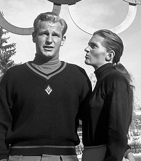
Andrea Mead Lawrence was an American alpine ski racer and environmentalist. She competed in three Winter Olympics and one additional World Championship, and was the first American alpine skier to win two Olympic gold medals.

Mammoth Yosemite Airport is a town-owned public airport seven miles east of Mammoth Lakes, in Mono County, California, United States. Also known as Mammoth Lakes Airport or Mammoth-June Lake Airport, it is mainly used for general aviation, but has scheduled passenger flights operated by one airline which primarily serves the airport on a seasonal basis during the winter ski season. Additional scheduled passenger service for the Mammoth area is seasonally available at the nearby Eastern Sierra Regional Airport located in Bishop, CA.

U.S. Route 395 (US 395) is a United States Numbered Highway, stretching from Hesperia, California to the Canadian border in Laurier, Washington. The California portion of US 395 is a 557-mile (896 km) route which traverses from Interstate 15 (I-15) in Hesperia, north to the Oregon state line in Modoc County near Goose Lake. The route clips into Nevada, serving the cities Carson City and Reno, before returning to California.

Minaret Summit is a mountain pass on Highway 203 in the central Sierra Nevada. The pass, lying on the Madera-Mono County border, is within the Mammoth Ranger District of the Inyo National Forest and located near Devils Postpile National Monument, Mammoth Lakes, and Mammoth Mountain. The elevation of the pass is about 9,265 ft (2,824 m). Highway 203 ends at Minaret Summit. The road continues, now called Reds Meadow Road, until its dead end at the Reds Meadow Pack Station near the Rainbow Falls trailhead.

June Lake is a census-designated place in Mono County, California. It is located against the southern rim of the Mono Basin, 12.5 miles (20 km) south of Lee Vining, at an elevation of 7654 feet.

Casa Diablo Hot Springs is a hot springs and active geothermal location, near Mammoth Lakes and the Eastern Sierra Nevada, in Mono County, eastern California.
Kuna Peak is a summit on the boundary between Mono and Tuolumne counties, in the United States, is the highest point on Kuna Crest. With an elevation of 13,008 feet (3,965 m), Kuna Peak is the 146th-highest summit in the state of California, and is the third-highest mountain in Yosemite National Park.
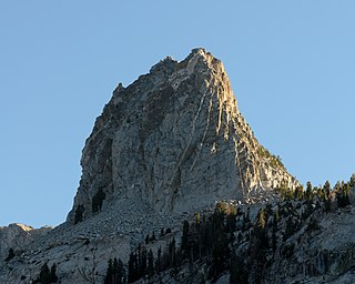
Crystal Crag is a 10,377-foot-elevation summit located in the Sierra Nevada mountain range in Mono County of northern California, United States. This photogenic landmark, popular with rock climbers, is situated approximately three miles south of the community of Mammoth Lakes, on land managed by Inyo National Forest. Topographic relief is significant as the north aspect rises 1,300 feet (396 meters) above Lake George in one-half mile. Crystal Lake lies below the west aspect and T J Lake below the east aspect. Precipitation runoff from the peak drains into these three lakes, thence north to Mammoth Creek. This mountain's toponym has been officially adopted by the United States Board on Geographic Names.
References
- 1 2 "Genny Smith: 1922 - 2018". The Sheet. Retrieved 30 July 2019.
- ↑ "Author Bio". Sierra East: Genny Smith, editor. University of California Press. Retrieved 2009-06-08.
- ↑ Bates, Colleen Dunn (2004). Mammoth from the inside: the honest guide to Mammoth and the Eastern Sierra. Prospect Park Publishing. p. 229. ISBN 0-9753939-0-1 . Retrieved September 15, 2011.
- 1 2 "Love the Wild Sierra? Thank Genny Smith" (PDF). The Sheet. October 1, 2016.
- ↑ "Trans-Sierra Highway". National Park Service.
- ↑ "Genevieve Hall Smith '43". Reed Magazine. June 2018.
- 1 2 "Genny Smith Books on the Eastern Sierra". Our Publications. Live Oak Press. Archived from the original on 2009-08-23. Retrieved 2009-06-08.
- ↑ "Adventuresome Hiker and Author Genny Smith" (PDF). Focus on Retirement Living. 2003. Archived from the original (PDF) on 2011-07-16.
- ↑ "2006 Annual Report" (PDF). Mono Lake Committee. 2006.
- ↑ "2017 Andrea Lawrence Award presented to Genny Smith". Mono Lake Committee.
| General | |
|---|---|
| National libraries | |
| Other | |
| | This biography of an American publisher is a stub. You can help Wikipedia by expanding it. |
| | This tourism-related article is a stub. You can help Wikipedia by expanding it. |
| | This California-related article is a stub. You can help Wikipedia by expanding it. |