
Idaho is a state in the Pacific Northwest region of the United States. To the north, it shares a small portion of the Canada–United States border with the province of British Columbia. It borders the states of Montana and Wyoming to the east, Nevada and Utah to the south, and Washington and Oregon to the west. The state's capital and largest city is Boise. With an area of 83,570 square miles (216,400 km2), Idaho is the 14th largest state by land area, but with a population of approximately 1.8 million, it ranks as the 13th least populous and the 6th least densely populated of the 50 U.S. states.

The Rocky Mountains, also known as the Rockies, are a major mountain range and the largest mountain system in North America. The Rocky Mountains stretch 3,000 miles in straight-line distance from the northernmost part of western Canada, to New Mexico in the southwestern United States. Depending on differing definitions between Canada and the U.S., its northern terminus is located either in northern British Columbia's Terminal Range south of the Liard River and east of the Trench, or in the northeastern foothills of the Brooks Range/British Mountains that face the Beaufort Sea coasts between the Canning River and the Firth River across the Alaska-Yukon border. Its southernmost point is near the Albuquerque area adjacent to the Rio Grande rift and north of the Sandia–Manzano Mountain Range. Being the easternmost portion of the North American Cordillera, the Rockies are distinct from the tectonically younger Cascade Range and Sierra Nevada, which both lie farther to its west.

Utah is a landlocked state in the Mountain West subregion of the Western United States. It is bordered to its east by Colorado, to its northeast by Wyoming, to its north by Idaho, to its south by Arizona, and to its west by Nevada. Utah also touches a corner of New Mexico in the southeast. Of the fifty U.S. states, Utah is the 13th-largest by area; with a population over three million, it is the 30th-most-populous and 11th-least-densely populated. Urban development is mostly concentrated in two areas: the Wasatch Front in the north-central part of the state, which is home to roughly two-thirds of the population and includes the capital city, Salt Lake City; and Washington County in the southwest, with more than 180,000 residents. Most of the western half of Utah lies in the Great Basin.

Caribou County is a county located in the U.S. state of Idaho. As of the 2020 Census the county had a population of 7,027. The county seat and largest city is Soda Springs.

St. Charles is a city in southern Bear Lake County, Idaho, United States, that is located near the northwestern shore of Bear Lake. Its population was 131 at the 2010 census, down from 156 in 2000.

Corinne is a city in Box Elder County, Utah, United States. The population was 809 at the 2020 census, up from the 2010 figure of 685.
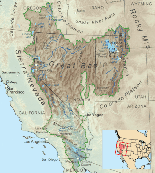
The Great Basin is the largest area of contiguous endorheic watersheds, those with no outlets, in North America. It spans nearly all of Nevada, much of Utah, and portions of California, Idaho, Oregon, Wyoming, and Baja California. It is noted for both its arid climate and the basin and range topography that varies from the North American low point at Badwater Basin in Death Valley to the highest point of the contiguous United States, less than 100 miles (160 km) away at the summit of Mount Whitney. The region spans several physiographic divisions, biomes, ecoregions, and deserts.
The Bear River is the largest tributary of the Great Salt Lake, draining a mountainous area and farming valleys northeast of the lake and southeast of the Snake River Plain. It flows through northeastern Utah, southwestern Wyoming, southeastern Idaho, and back into northern Utah, in the United States. Approximately 350 miles (560 km) long it is the longest river in North America that does not ultimately reach the sea.

Cache Valley(Shoshoni: Seuhubeogoi, “Willow Valley”) is a valley of northern Utah and southeast Idaho, United States, that includes the Logan metropolitan area. The valley was used by 19th century mountain men and was the site of the 1863 Bear River Massacre. The name, Cache Valley is often used synonymously to describe the Logan Metropolitan Area, one of the fastest growing metro areas in the US per capita — both in terms of economic GDP and population.

The Bear River Range, is a mountain range located in northeastern Utah and southeastern Idaho in the western United States.

Paradise Valley is a census-designated place (CDP) in Humboldt County, Nevada, United States, near the Santa Rosa Ranger District of Humboldt National Forest. It is located at the northern terminus of Nevada State Route 290, about 19 miles (31 km) northeast of U.S. Highway 95 and a total of 40 miles (64 km) north of Winnemucca. The town is located in a broad valley, with the Santa Rosa Range of mountains just to the northwest. At the 2010 census, the population of the CDP was 109.

The Mormon Mountains are located in Lincoln and Clark counties in Nevada, between 16 and 28 miles (45 km) northwest of Mesquite on I–15 in the Virgin Valley, east of the Meadow Valley Mountains and Meadow Valley and northeast of Moapa Valley. The highest point in the range is Mormon Peak, at 7,414 feet (2,260 m) above sea level. Another smaller mountain range lies to the east, called the East Mormon Mountains. The south fork of the Toquop Wash drains the east side of the range and continues on through the N–S linear ridge of the East Mormon Mountains.

The Coeur d'Alene River flows 37 miles (60 km) from the Silver Valley into Lake Coeur d'Alene in the U.S. state of Idaho. The stream continues out of Lake Coeur d'Alene as the Spokane River.

The Sawtooth Range is a mountain range of the Rocky Mountains in central Idaho, United States, reaching a maximum elevation of 10,751 feet (3,277 m) at the summit of Thompson Peak. It encompasses an area of 678 square miles (1,756 km2) spanning parts of Custer, Boise, Blaine, and Elmore counties, and is bordered to the east by the Sawtooth Valley. Much of the mountain range is within the Sawtooth Wilderness, part of the Sawtooth National Recreation Area and Sawtooth National Forest.

Blacktail Butte is a butte mountain landform rising from Jackson Hole valley in Grand Teton National Park in the U.S. state of Wyoming. Blacktail Butte was originally named Upper Gros Ventre Butte in an early historical survey conducted by the U.S. Geological Survey. Most of Blacktail Butte is densely forested with a mixed fir forest of lodgepole pine, Douglas fir and Engelmann spruce, with scattered pockets of aspen. There are several large sedimentary rock outcroppings, which are used by rock climbers. This butte is a principal landmark in Jackson Hole, with much of the Jackson Hole valley floor and many portions of the Teton Range visible from its hillsides.

The Centennial Mountains are the southernmost sub-range of the Bitterroot Range in the U.S. states of Idaho and Montana. The Centennial Mountains include the Western and Eastern Centennial Mountains. The range extends east from Monida Pass along the Continental Divide to Henrys Fork 48 km (30 mi) NNW of Ashton, Idaho; bounded on the west by Beaver Creek, on the north by Centennial Valley and Henrys Lake Mountains, on the east by Henrys Lake Flat, and on the south by Shotgun Valley and the Snake River Plain. The highest peak in the range is Mount Jefferson.
Lemhi is an unincorporated rural service point on the Lemhi River in Lemhi County, Idaho, United States. Lemhi is located on the east side of Idaho State Highway 28, 8 miles (13 km) south of Tendoy and 18 miles (29 km) northwest of Leadore. Lemhi consists of a combined general store and post office and a house. The post office services ZIP code 83465. As with the county, the name "Lemhi" is a variant spelling of Limhi, a personage of the Book of Mormon.

Diamond Peak is the highest point in the Lemhi Range in the Rocky Mountains in Idaho. At 12,202 feet (3,719 m) above sea level, it is the third highest peak in Idaho. It is situated 34.5 miles (55.5 km) east of Borah Peak in the Lost River Range, opposite the Little Lost River valley. It is the highest point in the Caribou-Targhee National Forest. The closest higher peak is Mount Church, which is 31.8 mi (51.2 km) to the west.
The 1934 Hansel Valley earthquake occurred on March 12 at approximately 8:05 a.m. MST with a moment magnitude of 6.6 and a maximum Mercalli intensity of VIII (Severe). The shock originated in the Hansel Valley at the north end of the Great Salt Lake in Utah in the United States. Damage was mostly confined to vulnerable buildings, and two people died. The dip-slip (normal) fault that generated the shock ruptured the surface of the ground and other geologic features were documented. A large aftershock occurred three hours after the initial event and may have caused additional damage.
Mount McCaleb is an 11,682-foot elevation (3,561 m) mountain summit located in Custer County, Idaho, United States.

