Geography of Santa Maria, Bulacan

Last updated
Barangay map of Santa Maria Santa Maria, Bulacan Map.png
Barangay map of Santa Maria

Santa Maria is a landlocked municipality in the province of Bulacan, Philippines comprising 24 barangays with a total land area of 90.925 square kilometers (35.106 sq mi).

Contents

The geographic location of Santa Maria may be regarded favorable with respect to its relative distance from the National Capital Region (NCR) and the Provincial Capitol. Lying at the eastern portion of Bulacan, which is just 32 kilometers away from Manila. In terms of location relative to its neighboring towns, Santa Maria is bounded on the north by the municipalities of Angat and Pandi; portion of San Jose del Monte City on the south; Norzagaray and other portions of San Jose del Monte City on the east; [1] and municipalities of Marilao and Bocaue on the western side.

Topography

The topography of Santa Maria is generally flat, however, it is hilly towards the north. This area covers the barangays of Silangan, Mag-asawang Sapa, Pulong Buhangin and some parts of Balasing with landscape ranging from 8 to 18 percent slope. The rest of the barangays have a slope range from level to undulating.

Network of small rivers can be found all throughout the municipal territory. Flowing downstream from the north, these tributaries converge into the Santa Maria River. This river plays a vital role in the physical configuration of Santa Maria and adjacent towns of Norzagaray and San Jose del Monte City as it drains water from these areas.

Climate

Santa Maria, Bulacan
Climate chart (explanation)
J
F
M
A
M
J
J
A
S
O
N
D
 
 
17
 
 
29
20
 
 
7
 
 
31
19
 
 
5
 
 
32
21
 
 
24
 
 
34
22
 
 
153
 
 
34
23
 
 
355
 
 
31
23
 
 
504
 
 
30
23
 
 
516
 
 
30
23
 
 
374
 
 
30
23
 
 
225
 
 
30
22
 
 
163
 
 
30
21
 
 
68
 
 
29
20
Average max. and min. temperatures in °C
Precipitation totals in mm
Source: Weathrebase
Imperial conversion
JFMAMJJASOND
 
 
0.7
 
 
84
68
 
 
0.3
 
 
88
66
 
 
0.2
 
 
90
70
 
 
0.9
 
 
93
72
 
 
6
 
 
93
73
 
 
14
 
 
88
73
 
 
20
 
 
86
73
 
 
20
 
 
86
73
 
 
15
 
 
86
73
 
 
8.9
 
 
86
72
 
 
6.4
 
 
86
70
 
 
2.7
 
 
84
68
Average max. and min. temperatures in °F
Precipitation totals in inches

Santa Maria has a climate “first type” which is defined as having two pronounced seasons: Dry from November to April and wet during the rest of the year. [2] During the dry months, precipitation is less because of the prevailing easterly wind blow to produce rainfall in its leeward side.

The Köppen climate system classifies Santa Maria climate as tropical monsoon (Am) due to its location and precipitation characteristics. This means that the municipality has two pronounced seasons: dry and wet seasons.

Santa Maria's most perceptible months start from May and may have its maximum in August, which gradually decreases until December. During these most months, thunderstorms and rain showers causes precipitation in May and June while the rest is primarily due to the southeast monsoon that prevails on this particular part of the year. Others which occur in November and December are caused by tropical cyclones that pass through the area.

Temperature

The annual mean temperature in the area is 27.7 °C (81.9 °F). The warmest month is May with mean temperature of 29 °C (84 °F) while the coldest is January at 25.2 °C (77.4 °F).

Relative humidity

The mean annual relative humidity in the area is 77%, which is under a normal condition. The mean monthly relative humidity is lowest in March at 64% and highest in September at 84%.

Ground water

The source of potable water of Santa Maria is purely dependent from its aquifer underneath it. Although the town is not rich in surface water, its ground water resources has sufficiently provide Santa Maria with their present requirement. Ground water in Santa Maria is essentially under shallow well areas, which means that fresh water can be easily found at a depth of about 20 meters below the ground surface. [3] However, at present, potable water is sourced at 100 meters above. On the contrary, this finite resource has been badly contaminated by infiltration of sewage in some shallow wells at barangays San Jose Patag, Catmon, Pulong Buhangin, Santa Clara and Bagbaguin. [3]

Soil

Soil suitability

The soils in Santa Maria is classified under three (3) categories namely soils of the Alluvial Landscape, soils of the Piedmont Landscape and soils of the Hilly Landscape. [2]

Alluvial landscape

Soils range from clayey to fine clayey somewhat poorly to poorly drained deep soils. These soils are principally grown to paddy rice and can be used for fishpond during rainy season. This landscape is composed of two (2) minor landform units as follows:

1. River terraces and levees – Narrow river terraces are topographic surfaces, which mark former valley floor levels and resulting from seasonal stream. The levels are elevated landforms slightly above the narrow river terraces. Some areas are subject to slight to moderate seasonal flooding in some years.
2. Low Alluvial terraces and depressions – It consists of the slightly dissected broad low alluvial terraces depressions and narrow alluvial valleys.

Moreover, soil series of the Alluvial Landscape consists of the Batia and Tagulod Series. Both series has low to adequate organic matter content and inherent fertility. However, Batia Series can be found on a relative steeper slopes covering the barangays of Lalakhan, Bagbaguin and Santa Clara. Tagulod Series on the other hand, covers the barangays of Manggahan, Caysio, Caypombo, Camangyanan, Tumana and Parada which is regarded to be generally utilized under rice production during wet season.

Piedmont landscape

It consists of gently undulating to rolling tuffaceous and sedimentary foot slopes slightly above and adjacent to the plain and free from local flooding hazard. This landscape, however, is composed of two soils series namely the Pulong Buhangin Series and Maysan Series. Pulong Buhangin Series has deficient organic matter content and high to moderate inherent fertility. This is principally utilized for paddy rice and built-up areas. Non-irrigated paddy rice constitutes the principal crop during wet season. These soils are left fallowed during dry season due to lack of irrigation and rainfall. These areas can be found in the central to upper portion of Santa Maria. Meanwhile, the Maysan series consists of very gently sloping to gently undulating shallow moderately drained soils that is formed on degraded tuffaceous sandstone footslopes. This series is mainly utilized for paddy ricefields during wet season and generally left idle during dry season

Hilly landscape

These soils are primarily in rolling sedimentary hills. The drainage is good with low to medium natural fertility. These areas can be found at barangays Pulong Buhangin, Mag-asawang Sapa, Balasing, Bulac, San Vicente and Guyong. These soils are primarily under pasture grass. Some cultivated areas are grown to diversified cropping.

Soil fertility

Soil pH

Soil pH measures the level of acidity of the soil – the lower the pH, the more acidic the soil. Most parts of Santa Maria are medium acidic ranging from 5.6 to 6.0 pH. Includes the barangays of Silangan, Mag-asawang Sapa, Caypombo, Caysio, Manggahan, Santa Cruz, Poblacion, Guyong, Balasing, Bulac, Catmon, San Gabriel, San Vicente, Camangyanan and Buenavista. The barangays of Pulong Buhangin, Santa Clara, Lalakhan, Tumana and Parada are strongly acidic ranging 5.1 to 5.5 pH and slightly acidic for the barangay of San Jose Patag ranging from 6.1 to 6.5 pH.

Available phosphorus

Most parts of Santa Maria are low in phosphorus ranging from 0 ppm to 9 ppm. It includes the barangays of Silangan, Mag-asawang Sapa, Caypombo, Caysio, Manggahan, Santa Cruz, Santa Clara, Lalakhan, Poblacion, Guyong, Balasing, Bulac, San Jose Patag, Tumana, San Gabriel, Parada and San Vicente. Other barangays such as Pulong Buhangin, Camangyanan and Buenavista are medium in phosphorus ranging from 9.0 ppm to 20.0 ppm.

Available potassium

Most parts of Santa Maria are sufficient in Potassium ranging from 100 ppm and above. It includes the barangays of Mag-asawang Sapa, Santa Clara, Poblacion, Guyong, Balasing, Bulac, San Jose Patag, Parada, San Vicente, Camangyanan and Buenavista. However, Silangan, Caypombo, Caysio, Manggahan, Santa Cruz, Tumana, San Gabriel and Pulong Buhangin are deficient in Potassium ranging from 0 ppm to 100 ppm.

Geology

Guadalupe Formation is the major underlying geological structure present in the territory of the municipality of Santa Maria. Outcrops of volcanic tuff are foundThis is made up of two formations namely Alat Conglomerate and Diliman Tuff. Alat Conglomerate is characterized by its consolidated pebbles, gravel or boulder beds composition. While Diliman Tuff is generally made up of an almost flat-lying sequence of vitric tuffs and welded volcanic breccias with subordinate amounts of tuffaceous, fine- to medium-grained sandstone. It also underlies areas between Sta. Maria and Bulu rivers in Bulacan. Based on this makeup, the whole area of Santa Maria is regarded to be very suitable to hold structures necessary for urban development.

Ground shaking

The primary hazard or danger that can be brought by an earthquake is the effect of ground shaking. Buildings or properties can be damaged by the shaking itself or by the ground beneath them settling to a different level than it was before the earthquake. Santa Maria is fortunate to be free from fault lines. The nearest fault line is found at San Jose del Monte City which is just 17 kilometers away from its city proper. However, ground shaking can still be experienced by the town which can pose hazard to properties. Using the Rapid Earthquake Damage Assessment System (REDAS), the planning team was able to simulate the effect of ground shaking at Santa Maria if the nearest fault line located at San Jose del Monte City would move at magnitude 7 and 5 meter depth earthquake. The side effect is estimated to incur slight damage.

Related Research Articles

<span class="mw-page-title-main">San Jose del Monte</span> Component city in Bulacan, Philippines

San Jose del Monte, officially the City of San Jose del Monte, is a 1st class component city in the province of Bulacan, Philippines. According to the 2020 census, it has a population of 651,813 people, making it the largest local government unit within the province of Bulacan and Central Luzon, and the 18th most populated city in the Philippines.

<span class="mw-page-title-main">Rodriguez, Rizal</span> Municipality in Rizal, Philippines

Rodriguez, officially the Municipality of Rodriguez, is a 1st class urban municipality in the province of Rizal, Philippines. According to the 2020 census, it has a population of 443,954 people making it the most populous municipality in the country. Pending an affirmation through plebiscite, Republic Act No. 11812 repealed Batas Pambansa Blg. 275 and intend to revert to its original municipal name Montalban.

<span class="mw-page-title-main">Sampaloc, Manila</span> District of Metro Manila, Philippines

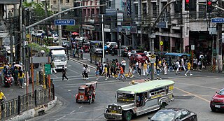
Sampaloc is a district of Manila, Philippines. It is referred to as the University Belt or simply called "U-Belt" for numerous colleges and universities are found within the district such as the University of Santo Tomas, the oldest extant university in Asia; the National University, the first private nonsectarian and coeducational institution in the Philippines; the Far Eastern University, known for its Art Deco campus and cultural heritage site of the Philippines; and the University of the East, once dubbed as the largest university in Asia in terms of enrollment. The district is bordered by the districts of Quiapo and San Miguel in the south, Santa Mesa district in the south and east, Santa Cruz district in the west and north, and Quezon City in the northeast.

<span class="mw-page-title-main">Caloocan</span> Highly urbanized city in Metro Manila, Philippines

Caloocan, officially the City of Caloocan, is a 1st class highly urbanized city in Metro Manila, Philippines. According to the 2020 census, it has a population of 1,661,584 people making it the fourth-most populous city in the Philippines.

<span class="mw-page-title-main">San Mateo, Rizal</span> Municipality in Rizal, Philippines

San Mateo, officially the Municipality of San Mateo, is a 1st class urban municipality in the province of Rizal, Philippines. According to the 2020 census, it has a population of 273,306.

<span class="mw-page-title-main">San Francisco de Macorís</span> Place in Duarte, Dominican Republic

San Francisco de Macorís is a city in the Dominican Republic located in the northeast portion of the island, in the Cibao region. It is the capital of the Duarte Province and the sixth most populated city in the country. The name San Francisco de Macorís comes from a combination of the name of Saint Francis, patron saint of the Franciscan Order and the territory's old name, which is Macorix.

<span class="mw-page-title-main">Santa Cruz, Laguna</span> Capital of Laguna, Philippines

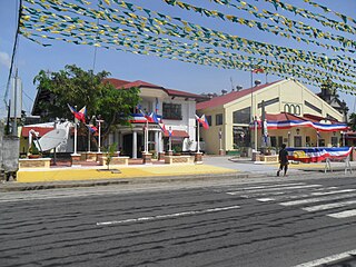
Santa Cruz, officially the Municipality of Santa Cruz, is a 1st class municipality and capital of the province of Laguna, Philippines. According to the 2020 census, it has a population of 123,574 people.

<span class="mw-page-title-main">Taytay, Rizal</span> Municipality in Rizal, Philippines

Taytay, officially the Municipality of Taytay, is a 1st class urban municipality in the province of Rizal, Philippines. It is also known as the Garments Capital of the Philippines.

<span class="mw-page-title-main">Santa Maria, Bulacan</span> Municipality in Bulacan, Philippines

Santa Maria, officially the Municipality of Santa Maria, is a 1st class urban municipality in the province of Bulacan, Philippines. According to the 2020 census, it has a population of 289,820 people. representing 7.8% of the population of the province.

<span class="mw-page-title-main">Rosario, Cavite</span> Municipality in Cavite, Philippines

Rosario, officially the Municipality of Rosario, is a 1st class municipality in the province of Cavite, Philippines. According to the 2020 census, it has a population of 110,807 people.

<span class="mw-page-title-main">Olutanga, Zamboanga Sibugay</span> Municipality in Zamboanga Sibugay, Philippines

Olutanga, officially the Municipality of Olutanga, is a 4th class municipality in the province of Zamboanga Sibugay, Philippines. According to the 2020 census, it has a population of 38,438 people.

<span class="mw-page-title-main">San Jose, Camarines Sur</span> Municipality in Camarines Sur, Philippines

San Jose, officially the Municipality of San Jose, is a 4th class municipality in the province of Camarines Sur, Philippines. According to the 2020 census, it has a population of 43,973 people.

<span class="mw-page-title-main">Santa Maria, Laguna</span> Municipality in Laguna, Philippines

Santa Maria, officially the Municipality of Santa Maria, is a 2nd class municipality in the province of Laguna, Philippines. According to the 2020 census, it has a population of 34,511 people.

<span class="mw-page-title-main">Naujan</span> Municipality in Oriental Mindoro, Philippines

Naujan, officially the Municipality of Naujan, is a 1st class municipality in the province of Oriental Mindoro, Philippines. Its population was 109,587 at the 2020 census.

<span class="mw-page-title-main">Marikina River</span> River in Calabarzon, Philippines

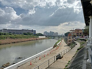
The Marikina River is a river in eastern Metro Manila, Philippines. It is the largest tributary of the Pasig River, with headwaters located in the Sierra Madre Mountains in Rodriguez, Rizal province.

<span class="mw-page-title-main">Roman Catholic Diocese of Malolos</span> Latin Catholic diocese in the Philippines

The Diocese of Malolos is a Latin Church ecclesiastical jurisdiction or diocese of the Catholic Church in the Philippines, encompassing the whole Province of Bulacan and Valenzuela City in metropolitan Manila and is a suffragan to the metropolitan Archdiocese of Manila. The mother church of the Diocese is the Cathedral-Basilica of the Immaculate Conception located in Malolos City, Bulacan. The Blessed Virgin Mary, under the title of Immaculate Conception is the principal patroness of the diocese.

<span class="mw-page-title-main">Upper Marikina River Basin Protected Landscape</span>

The Upper Marikina River Basin Protected Landscape is a protected area in the Province of Rizal in the Philippines, which forms the upper area of the drainage basin of the Marikina River.

Local elections were held in Bulacan on May 9, 2016, as part of the 2016 Philippine general election. Voters selected their candidates of choice for all local positions: a town mayor, vice mayor and town councilors, as well as members of the Sangguniang Panlalawigan, the vice-governor, governor and representatives for the four districts of Bulacan and the lone district of San Jose del Monte.

<span class="mw-page-title-main">Atimonan</span> Municipality in Quezon, Philippines

Atimonan, officially the Municipality of Atimonan, is a 1st class municipality in the province of Quezon, Philippines. According to the 2020 census, it has a population of 64,260 people.

<span class="mw-page-title-main">Our Lady of Mount Carmel Parish Church (Pulong Buhangin)</span> Roman Catholic church in Bulacan, Philippines

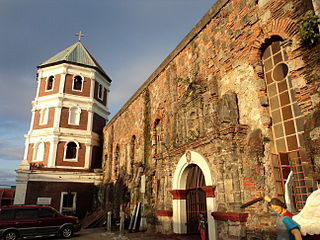
The Our Lady of Mount Carmel Parish, commonly referred as Nuestra Señora Del Carmen Parish, is a Roman Catholic church situated in Km. 38, Barangay Pulong Buhangin, Santa Maria, in the province of Bulacan, Philippines. It is under the jurisdiction of the Roman Catholic Diocese of Malolos and within the Vicariate of Santa Maria.

References

  1. "Geophysical Sector". City of San Jose del Monte. Retrieved 21 January 2022.
  2. 1 2 "Philippines: Water District Development Sector Project – Santa Maria Subproject" (PDF). Asian Development Bank. October 2020. p. 25. Retrieved 21 January 2022.
  3. 1 2 "Philippines: Water District Development Sector Project – Santa Maria Subproject" (PDF). Asian Development Bank. October 2020. p. 26. Retrieved 21 January 2022.