George Conrad Hutzler Farm

Last updated

George Conrad Hutzler Farm
Hutzler Farm.jpg
USA Michigan location map.svg
Red pog.svg
Usa edcp location map.svg
Red pog.svg
Location South Manitou Island
Nearest city Glen Haven, Michigan
Coordinates 45°1′22″N86°7′36″W / 45.02278°N 86.12667°W / 45.02278; -86.12667
Area160 acres (65 ha)
NRHP reference No. 91000466 [1]
Added to NRHPMay 3, 1991

The George Conrad Hutzler Farm, also known as the Conrad Hutzler Farm, is a historic farmstead located on South Manitou Island in Lake Michigan. One of the farm's owners, George Conrad Hutzler, Jr., was the first to experiment with hybridization of Rosen rye and Michelite pea beans; within 20 years of his experimentation, 80% of the pea bean crop in the United States was descended from Michelite seeds grown on South Manitou Island. [2] It was listed on the National Register of Historic Places in 1991. [1]

Contents

History

George Conrad Hutzler was born in about 1822 and lived in the small Village Oberkrumbach  [ de ] near Kirchensittenbach, Bavaria. [3] In 1845, he emigrated for America along with his wife Magdalena and their son. George Conrad Hutzler likely worked as a sailor on the Great Lakes. In 1854 his half-brother George Johann Hutzler arrived from Germany and also settled in Buffalo. George Johann Hutzler and his family later moved to South Manitou Island, likely in 1860, and George Conrad Hutzler followed in about 1868. In 1870, he staked a claim to this farm near his half-brother.

George Conrad Hutzler died in 1896 and was buried on the farm. [3] His son George Conrad Jr.(born on the island in 1872) took over ownership of the farm. George Conrad Jr. and his son Lewis ran the farm for a number of years. In the 1920s, researchers from Michigan Agricultural College (now Michigan State University) chose South Manitou Island to work on experimental hybridization of rye plants, due primarily to its isolation from other rye crops which prevented accidental cross-pollination. [4] The Hutzlers were notable partners in the effort, and won a number of awards for the varieties of Rosen Rye and the Michilite pea bean that they developed.

However, during the Great Depression, transportation on the Great Lakes declined, and South Manitou Island farmers had a more difficult time getting their crops to market; even the experimental farming that many farm families, including the Hutzlers, engaged in could not sustain the farms on the island. [2] As a result, families began leaving in the 1940s. [4] Louis Hutzler eventually married and moved to Hastings, Michigan. George Conrad Hutzler Jr. died on the farm in 1951 and is buried there.

After George Conrad Hutzler Jr.'s death, a development group headed by William Boals purchased the farm from his son. [4] They rented the farm to the Riker family. However, development activities never materialized, and in 1970 Boals sold the property to the National Park Service. The Rikers, by then the last active farm family on the island, were asked to relocate, and the farm (and other properties on South Manitou Island) were included as part of the Sleeping Bear Dunes National Lakeshore.

Description

Farmhouse Hutzler Farmhouse.jpg
Farmhouse

The George Conrad Hutzler Farm is located on 160 acres (65 ha) near the center of the island. [2] The farm contains a house, barn, five shed, a chicken coop, and a granary surrounded by old fields. [4]

The George Conrad Hutzler house is a 1+12-story wood-frame structure with clapboard siding on a concrete foundation. [2] The house has a gable roof covered in hexagonal slate tiles. The main section measures 30 feet (9.1 m) by 30 feet (9.1 m), and a small shed-roof addition is built on one side.

The associated barn is a gable-roofed structure on a wooden foundation. [2] It is clad with vertical board siding and roofed with wooden shingles. It measures 58 feet (18 m) by 36 feet (11 m) and has a pair of large double wooden doors on one side.

The five sheds are all gable roofed wooden structures. [2] They are:

The chicken coop consists of two connected structures. [2] The larger structure measures 10 feet (3.0 m) by 22 feet (6.7 m), with an asphalt-covered shed roof and vertical board siding on a wood foundation. The smaller part measures 10 feet (3.0 m) by 13 feet (4.0 m), with an asphalt-covered gable roof and vertical board siding on a wood foundation.

The granary is a 1+12-story wood-frame structure measuring 18 feet (5.5 m) by 20 feet (6.1 m), with a small one-story shed attached to the rear. [2] It has a wood foundation and is covered by a gable roof with wood shingles. A corn crib is on one side.

Related Research Articles

<span class="mw-page-title-main">South Manitou Island</span> Island in Michigan

South Manitou Island is located in Lake Michigan, approximately 16 miles (26 km) west of Leland, Michigan. It is part of Leelanau County and the Sleeping Bear Dunes National Lakeshore. The uninhabited island is 8.277 sq mi (21.44 km2) in land area and can be accessed by a ferry service from Leland. Guided tours on open-air vehicles are available to visitors, but most traffic is on foot. Larger North Manitou Island lies to its north.

<span class="mw-page-title-main">Manitou Island Light Station</span> Lighthouse in Michigan, United States

The Manitou Island Light Station is a lighthouse located on Manitou Island, off the tip of Michigan's Keweenaw Peninsula in Lake Superior. It was listed on the National Register of Historic Places in 1984.

<span class="mw-page-title-main">North Manitou Island Lifesaving Station</span> United States historic place

North Manitou Island Lifesaving Station, also known as North Manitou Coast Guard Station, is a complex of buildings located on North Manitou Island, which is part of Sleeping Bear Dunes National Lakeshore in Michigan, in the U.S. The complex was constructed as a life-saving station. It is the only remaining station which was in use during all three periods of lifesaving service history, from the early volunteer period through operation by the United States Life-Saving Service and the United States Coast Guard. It was declared a National Historic Landmark in 1998.

<span class="mw-page-title-main">Gladden Windmill</span> United States historic place

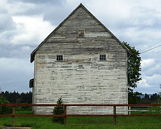
Gladden Windmill is an historic windmill formerly located on Pigeon Valley Road in Napoli, Cattaraugus County, New York. The windmill was built in 1890 and is a well-preserved example of a vertical wind turbine built during the 19th century. Although no longer operational, the turbine is a rare example of wind power technology in the United States.

<span class="mw-page-title-main">Manning–Kamna Farm</span> Historic house in Oregon, United States

The Manning–Kamna Farm is a private farm adjacent to Hillsboro in Washington County, Oregon, United States. Settled in the 1850s, ten buildings built between 1883 and 1930 still stand, including the cross-wing western farmhouse. These ten structures comprise the buildings added to the National Register of Historic Places in 2007 as an example of a farm in the region from the turn of the 20th century. Until the 1950s the farm was used to grow seeds, including rye grass and vetch. Listed buildings on the property include a barn, smokehouse, pumphouse, woodshed, and privy.

<span class="mw-page-title-main">Edisen Fishery</span> United States historic place

The Edisen Fishery is a fishery located in Rock Harbor in the Isle Royale National Park in Michigan. It was designated a Michigan State Historic Site in 1976 and listed on the National Register of Historic Places in 1977.

<span class="mw-page-title-main">Unity Ranger Station</span> United States historic place

The Unity Ranger Station is a United States Forest Service compound consisting of five buildings and a lookout tower in the Wallowa-Whitman National Forest of northeastern Oregon. It was previously the administrative headquarters for the Unity Ranger District. It is located in the small unincorporated community of Unity, Oregon. The historic structures were built in the rustic style by the Civilian Conservation Corps between 1936 and 1938. Today, the ranger station is only used during the summer months to house Forest Service fire crews. The ranger station is listed on the National Register of Historic Places.

<span class="mw-page-title-main">Iron County MRA</span> United States historic place

The Iron County MRA is a Multiple Resource Area addition to the National Register of Historic Places, which includes 72 separate structures and historic districts within Iron County, Michigan, United States of America. These properties were identified and placed on the Register in 1983, with the exception of one property that was placed on the Register in 1993.

<span class="mw-page-title-main">Jackson Park Town Site Addition Brick Row</span> United States historic place

Jackson Park Town Site Addition Brick Row is a group of three historic houses and two frame garages located on the west side of the 300 block of South Third Street in Lander, Wyoming. Two of the homes were built in 1917, and the third in 1919. The properties were added to the National Register of Historic Places on February 27, 2003.

<span class="mw-page-title-main">Roba Ranch</span> United States historic place

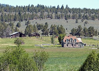
The Roba Ranch is a pioneer ranch located near the small unincorporated community of Paulina in Crook County, Oregon. The ranch is named for George and Mary Roba, sheep ranchers who acquired the property in 1892. Most of the important ranch buildings were constructed by the Roba family between about 1892 and 1910. Today, the ranch covers 1,480 acres (6.0 km2) and is privately owned. The ranch was listed on the National Register of Historic Places in 2007.

The John and Katharine Tunkun Podjun Farm is a farm located at 9582 East 1 Mile Road in Ellsworth, Michigan. It was listed on the National Register of Historic Places in 2002.

<span class="mw-page-title-main">Bangor Elevator</span> United States historic place

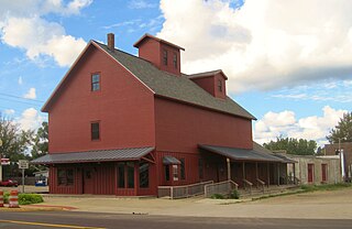
The Bangor Elevator is a grain elevator located at 142 West Monroe Street in Bangor, Michigan. It was listed on the National Register of Historic Places in 2009.

<span class="mw-page-title-main">Hutzler's Barn</span> United States historic place

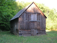
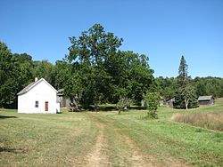
Hutzler's Barn is an agricultural building located north of the cemetery on South Manitou Island. It is the oldest remaining portion of George Johann Hutzler's homestead, and is significant for its role in the development of prize-winning Rosen rye and Michelite seeds. It was listed on the National Register of Historic Places in 1978.

<span class="mw-page-title-main">Pinhook Methodist Church and Cemetery</span> Historic church in Indiana, United States

The Pinhook Methodist Church and Cemetery are located in New Durham Township, LaPorte County, Indiana at Wozniak Road with State Road 2. Known as the village of Pinhook, formerly New Durham. The village is mostly residential along the south side of State Road 2. The site includes the Pinhook Methodist Church (1847), the Pinhook Cemetery (1850), the cemetery storage shed, and the old pump.

<span class="mw-page-title-main">Stahly–Nissley–Kuhns Farm</span> United States historic place

The Stahly–Nissley–Kuhns Farm is a historic farm located at Nappanee, Elkhart County, Indiana. Nappanee was established in 1874. The Farm is part of Amish Acres, which includes the old farmstead and additional structures brought in to show Amish life.

<span class="mw-page-title-main">Rochester Grain Elevator</span> United States historic place

The Rochester Grain Elevator, formerly the Griggs Brothers Grain Elevator, is a grain elevator located at 303 East University Drive in Rochester, Michigan. It was listed on the National Register of Historic Places in 2010.

<span class="mw-page-title-main">Langford and Lydia McMichael Sutherland Farmstead</span> United States historic place

The Langford and Lydia McMichael Sutherland Farmstead is a farm located at 797 Textile Road in Pittsfield Charter Township, Michigan. It was listed on the National Register of Historic Places in 2006. It is now the Sutherland-Wilson Farm Historic Site.

<span class="mw-page-title-main">Gordon Hitt Farmstead</span> United States historic place

The Gordon Hitt Farmstead is a former farm located at 4561 North Lake Road near Clark Lake, Michigan. It was listed on the National Register of Historic Places in 1994. It now serves as a vacation rental.

<span class="mw-page-title-main">Booth-Dunham Estate</span> United States historic place

The Booth-Dunham Estate is a single-family home located at 6059 South Ninth Street Texas Charter Township near Kalamazoo, Michigan. It was listed on the National Register of Historic Places in 1998.

<span class="mw-page-title-main">Drake Farmstead</span> United States historic place

The Benjamin and Maria (Ogden) Drake Farm, also known as the Drake Farmstead, is a farmstead located at 927 North Drake Road in Kalamazoo, Michigan. It was listed on the National Register of Historic Places in 2012, and as of 2021 is open to the public as the Drake Farmstead Park.

References

  1. 1 2 "National Register Information System". National Register of Historic Places . National Park Service. July 9, 2010.
  2. 1 2 3 4 5 6 7 8 Jill York O'Bright (October 22, 1986), National Register of Historic Places Inventory: George Conrad Hutzler Farm
  3. 1 2 The Hutzlers: Roots, Routes & Rumors (PDF), www.manitouislandsarchives.org, archived from the original (PDF) on February 2, 2014
  4. 1 2 3 4 Brenda Wheeler Williams; Arnold R Alanen; William H Tishler (1996), Coming Through with Rye: An Historic Agricultural Landscape Study of South Manitou Island at Sleeping Bear Dunes National Lakeshore, Michigan (PDF), Midwest Field Area, National Park Service, pp. 67, 71–74, 94–106, archived from the original (PDF) on February 25, 2014

Further reading

CR Robinson (August 1986), National Register of Historic Places Inventory: George Conrad Hutzler Farm Photos