Georgia's congressional districts

Last updated

Map of Georgia's congressional districts from 2023 to 2025 Georgia Congressional Districts, 118th Congress.svg
Map of Georgia's congressional districts from 2023 to 2025
Map of Georgia's congressional districts from 2025 Georgia Congressional Districts, 119th Congress.svg
Map of Georgia's congressional districts from 2025

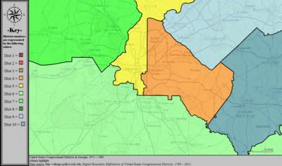
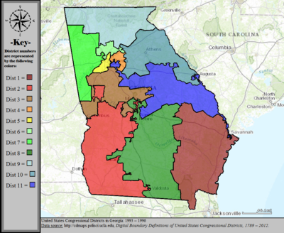
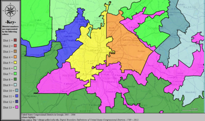
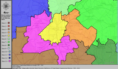
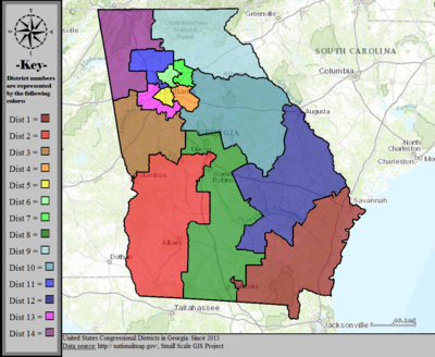
Georgia is represented in the United States House of Representatives by 14 elected representatives, each campaigning and receiving votes in only one district of the 14.

Contents

After the 2000 census, the State of Georgia was divided into 13 congressional districts, increasing from 11 due to reapportionment. The state was redistricted again in 2005, and 2007, although the number of districts remained 13. In 2013, the number of representatives increased again with rising population to 14 members.

Current districts and representatives

List of members of the United States House delegation from Georgia, their time in office, district maps, and the district political ratings according to the CPVI. The delegation has a total of 14 members, with nine Republicans and five Democrats as of 2023.

Current U.S. representatives from Georgia
DistrictMember
(Residence) [1]
PartyIncumbent since CPVI
(2022) [2]
District map
1st Buddy Carter, Official Portrait, 114th Congress.jpg
Buddy Carter
(St. Simons Island)
RepublicanJanuary 3, 2015R+9 Georgia's 1st congressional district (since 2023).svg
2nd Sanford Bishop 117th Congress.jpg
Sanford Bishop
(Albany)
DemocraticJanuary 3, 1993D+3 Georgia's 2nd congressional district (since 2023).svg
3rd Drew Ferguson 115th Congress 2.jpeg
Drew Ferguson
(The Rock)
RepublicanJanuary 3, 2017R+18 Georgia's 3rd congressional district (since 2023).svg
4th Hank Johnson official photo.jpg
Hank Johnson
(Lithonia)
DemocraticJanuary 3, 2007D+27 Georgia's 4th congressional district in Atlanta (since 2023).svg
5th Rep. Nikema Williams official photo, 117th Congress.jpg
Nikema Williams
(Atlanta)
DemocraticJanuary 3, 2021D+32 Georgia's 5th congressional district in Atlanta (since 2023).svg
6th Rep. Rich McCormick official photo, 118th Congress (1).jpg
Rich McCormick
(Suwanee)
RepublicanJanuary 3, 2023R+11 Georgia's 6th congressional district in Atlanta (since 2023).svg
7th Lucy McBath, official portrait, 116th Congress.jpg
Lucy McBath
(Marietta)
DemocraticJanuary 3, 2019D+10 Georgia's 7th congressional district in Atlanta (since 2023).svg
8th Austin Scott official photo.jpg
Austin Scott
(Tifton)
RepublicanJanuary 3, 2011R+16 Georgia's 8th congressional district (since 2023).svg
9th Rep. Andrew Clyde official photo.png
Andrew Clyde
(Athens)
RepublicanJanuary 3, 2021R+22 Georgia's 9th congressional district (since 2023).svg
10th Rep. Mike Collins official photo, 118th Congress.jpg
Mike Collins
(Jackson)
RepublicanJanuary 3, 2023R+15 Georgia's 10th congressional district (since 2023).svg
11th Barry Loudermilk, official portrait, 115th congress.jpg
Barry Loudermilk
(Cassville)
RepublicanJanuary 3, 2015R+11 Georgia's 11th congressional district in Atlanta (since 2023).svg
12th Rick Allen Official Photo, 114th Congress.jpg
Rick Allen
(Augusta)
RepublicanJanuary 3, 2015R+8 Georgia's 12th congressional district (since 2023).svg
13th David Scott congressional portrait.jpg
David Scott
(Atlanta)
DemocraticJanuary 3, 2003D+28 Georgia's 13th congressional district in Atlanta (since 2023).svg
14th Marjorie Taylor Greene 117th Congress portrait (tight crop).jpeg
Marjorie Taylor Greene
(Rome)
RepublicanJanuary 3, 2021R+22 Georgia's 14th congressional district (since 2023).svg

Historical and present district boundaries

Table of United States congressional district boundary maps in the State of Georgia, presented chronologically. [3] All redistricting events that took place in Georgia between 1973 and 2013 are shown.

YearStatewide mapAtlanta highlight
1973–1982 United States Congressional Districts in Georgia, 1973 - 1982.tif United States Congressional Districts in Georgia (metro highlight), 1973 - 1982.tif
1983–1992 United States Congressional Districts in Georgia, 1983 - 1992.tif United States Congressional Districts in Georgia (metro highlight), 1983 - 1992.tif
1993–1996 United States Congressional Districts in Georgia, 1993 - 1996.tif United States Congressional Districts in Georgia (metro highlight), 1993 - 1996.tif
1997–2002 United States Congressional Districts in Georgia, 1997 - 2002.tif United States Congressional Districts in Georgia (metro highlight), 1997 - 2002.tif
2003–2006 United States Congressional Districts in Georgia, 2003 - 2006.tif United States Congressional Districts in Georgia (metro highlight), 2003 - 2006.tif
2007–2013 United States Congressional Districts in Georgia, 2007 - 2013.tif United States Congressional Districts in Georgia (metro highlight), 2007 - 2013.tif
2013–2023 United States Congressional Districts in Georgia, since 2013.tif United States Congressional Districts in Georgia (metro highlight), since 2013.tif

See also

Related Research Articles

Since California became a U.S. state in 1850, it has sent congressional delegations to the United States Senate and United States House of Representatives. Each state elects two senators to serve for six years, and members of the House to two-year terms.

<span class="mw-page-title-main">Oregon's congressional districts</span> U.S. House districts

The U.S. state of Oregon has had six United States congressional districts since 2023, when the 6th district was created as a result of the 2020 census. The 5th district was added as a result of the 1980 census, and boundaries were redrawn following the population changes to each district as determined by the 1990, 2000, 2010, and 2020 censuses.

Redistricting in the United States is the process of drawing electoral district boundaries. For the United States House of Representatives, and state legislatures, redistricting occurs after each decennial census.

<span class="mw-page-title-main">United States congressional delegations from Texas</span>

These are tables of congressional delegations from the State of Texas to the United States Senate and United States House of Representatives.

<span class="mw-page-title-main">United States congressional delegations from Ohio</span>

These are tables of congressional delegations from Ohio to the United States House of Representatives and the United States Senate.

Georgia became a U.S. state in 1788, which allowed it to send congressional delegations to the United States Senate and United States House of Representatives beginning with the 1st United States Congress in 1789. Each state elects two senators to serve for six years, and members of the House to two-year terms.

<span class="mw-page-title-main">1932 United States House of Representatives elections</span> House elections for the 73rd U.S. Congress

The 1932 United States House of Representatives elections were elections for the United States House of Representatives to elect members to serve in the 73rd United States Congress. They were held for the most part on November 8, 1932, while Maine held theirs on September 12. They coincided with the landslide election of President Franklin D. Roosevelt.

<span class="mw-page-title-main">Kansas's congressional districts</span>

Kansas is divided into 4 congressional districts, each represented by a member of the United States House of Representatives. The number of districts in Kansas remained unchanged after the 2010 census. Historically, the state has held as many as eight seats (1893–1933). The number of congressional seats decreased from five to four following the 1990 census. Between 1990 and 2000, the population of Kansas grew by 8.5% from 2,477,574 to 2,688,418, making it the 32nd most populated state; all four congressional seats were retained.

<span class="mw-page-title-main">Minnesota's congressional districts</span>

Minnesota is currently divided into eight congressional districts, each represented by a member of the United States House of Representatives. After the 2020 census, the number of Minnesota's seats remained unchanged.

<span class="mw-page-title-main">Ohio's congressional districts</span> Congressional districts in the U.S. state of Ohio

Ohio is divided into 15 congressional districts, each represented by a member of the United States House of Representatives. After the 2010 census, Ohio lost two House seats due to slow population growth compared to the national average, and a new map was signed into law on September 26, 2011. Starting in the 2022 midterms, per the 2020 United States census, Ohio will lose a congressional seat.

<span class="mw-page-title-main">Wisconsin's congressional districts</span> U.S. House Districts in the state of Wisconsin

Wisconsin is currently divided into 8 congressional districts, each represented by a member of the United States House of Representatives. After the 2020 census, the number of Wisconsin's seats remained unchanged.

<span class="mw-page-title-main">Pennsylvania's congressional districts</span> Congressional districting since 2003

After the 2000 census, the Commonwealth of Pennsylvania was divided into 19 congressional districts, decreasing from 21 due to reapportionment.

<span class="mw-page-title-main">Florida's congressional districts</span> U.S. House districts in the state of Florida

Florida is divided into 28 congressional districts, each represented by a member of the United States House of Representatives. After the 2020 census, the number of Florida's seats was increased from 27 to 28, due to the state's increase in population, and subsequent reapportionment in 2022.

<span class="mw-page-title-main">Arizona's congressional districts</span>

Arizona is divided into nine congressional districts, each represented by a member of the United States House of Representatives. Since the 2008 elections, Democrats and Republicans have alternated holding a majority of seats in the delegation in six of the last eight elections.

<span class="mw-page-title-main">Utah's congressional districts</span>

Utah is divided into 4 congressional districts, each represented by a member of the United States House of Representatives. After the 2010 census, Utah gained one House seat, and a new map was approved by the state legislature and signed into law by Governor Gary Herbert.

<span class="mw-page-title-main">Michigan's congressional districts</span> U.S. House districts in the state of Michigan

Michigan is divided into 13 congressional districts, each represented by a member of the United States House of Representatives.

<span class="mw-page-title-main">Iowa's congressional districts</span> U.S. House Districts in the state of Iowa

Iowa is divided into four congressional districts, each represented by a member of the United States House of Representatives. The state's congressional map is roughly divided by quadrants in the northeast, northwest, southeast, and southwest sections of Iowa.

<span class="mw-page-title-main">Washington's congressional districts</span> U.S. House districts in the state of Washington

The following is a list of the ten congressional districts in the U.S. state of Washington. From the time that Washington Territory was formed in 1853, through statehood in 1889, Washington Territory elected an at-large non-voting Delegate to the United States House of Representatives. At different times in its history, the state of Washington has also elected one or more representatives At-large statewide. Washington gained its 10th district following reapportionment after the 2010 census.

<span class="mw-page-title-main">Redistricting in Arizona</span>

The U.S. state of Arizona, in common with the other U.S. states, must redraw its congressional and legislative districts every ten years to reflect changes in the state and national populations. Redistricting normally follows the completion of the United States census, which is carried out by the federal government the first year of every decade; the most recent census took place in 2020. Historically, Arizona's legislature had control over the redistricting process. However, Proposition 106, passed in 2000, delegated the power to draw congressional and legislative boundaries to a bipartisan independent commission. The Arizona Independent Redistricting Commission (AIRC) comprises two Democrats, two Republicans, and one independent chair. County and local redistricting, which normally takes place along the same timeline as congressional and legislative redistricting, is carried out by the individual county and local governments rather than the AIRC.

<span class="mw-page-title-main">Maryland's congressional districts</span> U.S. House districts in the state of Maryland

Maryland is divided into eight congressional districts, each represented by a member of the United States House of Representatives. After the 2020 census, the number of Maryland's seats remained unchanged, giving evidence of stable population growth relative to the United States at large.

References

  1. "Office of the Clerk, U.S. House of Representatives". clerk.house.gov. Retrieved January 6, 2022.
  2. "2022 Cook PVI: District Map and List". Cook Political Report. Retrieved January 5, 2023.
  3. "Digital Boundary Definitions of United States Congressional Districts, 1789–2012" . Retrieved October 18, 2014.

Current maps and statistics

All links in this section are from the [Georgia Legislative and Congressional Reapportionment Office http://www.legis.ga.gov/joint/reapportionment/en-us/default.aspx] and apply to the maps first used for the 2012 congressional elections.

Maps in the following two sections are of the congressional districts adopted in 2005 and effective for the 2006 elections and the 110th Congress.

2007-2013 statewide maps

2007-2013 regional detail maps