Georgia State Route 251

Last updated

Georgia 251.svg

State Route 251
Georgia state route 251 map.png
Route information
Maintained by GDOT
Length 13.5 mi [1] (21.7 km)
Existed 1949 [2] [3] – present
Major junctions
South endBusiness Loop 95.svgUS 17.svgGeorgia 25.svg I95 Bus. / US 17 / SR 25 north of Darien
 I-95.svgBusiness Loop 95.svg I95 / I95 Bus. northwest of Darien
North endGeorgia 57.svg SR 57 in Townsend
Location
Counties McIntosh
Highway system
  • Georgia State Routes
Georgia 247.svg SR 247 SR 252 Georgia 252.svg

State Route 251 (SR 251) is a 13.5-mile-long (21.7 km) south–north state highway located in the east-central part of the U.S. state of Georgia. It travels entirely within McIntosh County.

Georgia (U.S. state) State of the United States of America

Georgia is a state in the Southeastern United States. It began as a British colony in 1733, the last and southernmost of the original Thirteen Colonies to be established. Named after King George II of Great Britain, the Province of Georgia covered the area from South Carolina south to Spanish Florida and west to French Louisiana at the Mississippi River. Georgia was the fourth state to ratify the United States Constitution, on January 2, 1788. In 1802–1804, western Georgia was split to the Mississippi Territory, which later split to form Alabama with part of former West Florida in 1819. Georgia declared its secession from the Union on January 19, 1861, and was one of the original seven Confederate states. It was the last state to be restored to the Union, on July 15, 1870. Georgia is the 24th largest and the 8th most populous of the 50 United States. From 2007 to 2008, 14 of Georgia's counties ranked among the nation's 100 fastest-growing, second only to Texas. Georgia is known as the Peach State and the Empire State of the South. Atlanta, the state's capital and most populous city, has been named a global city. Atlanta's metropolitan area contains about 55% of the population of the entire state.

McIntosh County, Georgia County in the United States

McIntosh County is a county located in the U.S. state of Georgia. As of the 2010 census, the population was 14,333. The county seat is Darien.

Contents

Route description

SR 251 begins at an intersection with I-95 Bus./US 17/SR 25 just north of Darien. Here, the roadway continues as Dunbar Street. The highway heads northwest, passing the Darien Inland Harbor Campground. It then has an interchange with Interstate 95 (I-95) northwest of the city. Here, I-95 Bus. reaches its northern terminus. Just past I-95 is access to the Preferred Outlets at Darien, an outlet mall. The highway then turns north, traveling through rural areas of the county, until it meets its northern terminus, an intersection with SR 57 in Townsend. Here, the roadway continues as Old Townsend Road. [1]

Intersection (road) A road junction where two or more roads either meet or cross at grade

An intersection is an at-grade junction where two or more roads meet or cross. Intersections may be classified by number of road segments, traffic controls, and/or lane design.

U.S. Route 17 (US 17) is a 124.20-mile-long (199.88 km) U.S. Highway in the U.S. state of Georgia. It travels south-to-north near the Atlantic Ocean, serving the Brunswick and Savannah metropolitan areas on its path from Florida at the St. Marys River to South Carolina at the Savannah River. Except for part of the highway in Savannah, which is concurrent with Interstate 16 and SR 404 Spur to the Talmadge Memorial Bridge to Hutchinson Island, US 17 is concurrent with State Route 25. SR 25 uses an older western alignment of US 17 into South Carolina.

Darien, Georgia City in Georgia, United States

Darien is a city in McIntosh County, Georgia, United States. It lies on Georgia's coast at the mouth of the Altamaha River, approximately 50 miles south of Savannah, and is part of the Brunswick, Georgia Metropolitan Statistical Area. The population of Darien was 1,975 at the 2010 census. The city is the county seat of McIntosh County. It is the second oldest planned city in Georgia and was originally called New Inverness.

No section of SR 251 is part of the National Highway System, a system of routes determined to be the most important for the nation's economy, mobility and defense. [4]

National Highway System (United States) highway system in the United States

The National Highway System (NHS) is a network of strategic highways within the United States, including the Interstate Highway System and other roads serving major airports, ports, rail or truck terminals, railway stations, pipeline terminals and other strategic transport facilities. Altogether, it constitutes the largest highway system in the world.

History

SR 251 was established in 1949 along an alignment from its current southern terminus north-northwest and then northwest of the city, to what is now the unincorporated community of Cox. [2] [3] In 1955, a short section from Darien to northwest of I-95 was paved. [5] [6] By 1963, the road's entire route was paved. [7] [8] By 1979, the road was moved to, and paved along its current alignment. [9] [10]

Major intersections

The entire route is in McIntosh County.

Locationmi [1] kmDestinationsNotes
0.00.0Business Loop 95.svgUS 17.svgGeorgia 25.svg I95 Bus. south / US 17 / SR 25 (North Way) / Dunbar Street Brunswick, Savannah Southern terminus; southern end of I-95 Bus. concurrency
1.11.8I-95.svgBusiness Loop 95.svg I95 (SR 405) / I95 Bus. ends Brunswick, Savannah Northern end of I-95 Bus. concurrency; northern terminus of I-95 Bus.; I-95 exit 49
Townsend 13.521.7Georgia 57.svg SR 57 / Old Townsend Road Eulonia, Ludowici Northern terminus
1.000 mi = 1.609 km; 1.000 km = 0.621 mi

See also

Related Research Articles

Georgia State Route 120 highway in Georgia

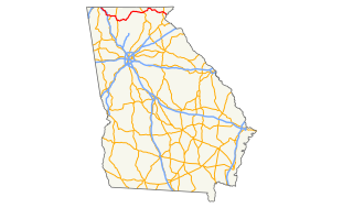
State Route 120 (SR 120) is a 90.7-mile-long (146.0 km) state highway that runs west-to-east through portions of Haralson, Paulding, Cobb, Fulton, and Gwinnett counties in northwestern part of the U.S. state of Georgia.

Georgia State Route 300 highway in Georgia

State Route 300, is a 107-mile-long (172 km) state highway in the southern part of the U.S. state of Georgia. Its southern terminus is at the Florida state line south-southeast of Thomasville, where the roadway continues as US 19/SR 57. This is also the southern terminus of SR 3, with which US 19 and SR 300 travel concurrently through the southern part of the state. Its northern terminus is at Interstate 75 (I-75) in Cordele.

Georgia State Route 233 highway in Georgia

State Route 233 (SR 233) is a 19.4-mile-long (31.2 km) north–south state highway in the central part of the U.S. state of Georgia. It travels through portions of Ben Hill and Wilcox counties.

State Route 2 (SR 2) is a 165-mile-long (266 km) east-west state highway in the far northern part of the U.S. state of Georgia. The highway serves southern suburbs of Chattanooga, Tennessee, as well as much of the mountainous area in the northern part of the state. It traverses the counties of Walker, Catoosa, Whitfield, Murray, Gilmer, Fannin, Union, Towns, and Rabun. It connects Flintstone, in the northwestern part of the state, with the South Carolina state line southeast of Clayton in the northern part and the northeastern part of the state. It also travels through Fort Oglethorpe, Ringgold, Ellijay, Blue Ridge, Blairsville, and Hiawassee. Parts of the highway in the Whitfield and Murray county area are designated as the Cohutta–Chattahoochee Scenic Byway.

Georgia State Route 36 highway in Georgia

State Route 36 (SR 36) is a 95.2-mile-long (153.2 km) state highway that travels southwest-to-northeast through portions of Harris, Talbot, Upson, Lamar, Butts, and Newton counties in the central part of the U.S. state of Georgia. The highways connects the Waverly Hall area with Covington, via Thomaston, Barnesville, and Jackson.

Georgia State Route 272 highway in Georgia

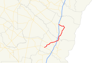
State Route 272 (SR 272) is a 15.4-mile-long (24.8 km) north–south state highway located in the east-central part of the U.S. state of Georgia. Its path is entirely within Washington County.

Georgia State Route 268 highway in Georgia

State Route 268 (SR 268) is a 22.9-mile-long (36.9 km) southwest–northeast state highway located in the south-central part of the U.S. state of Georgia. It travels within portions of Coffee and Jeff Davis counties.

Georgia State Route 266 highway in Georgia

State Route 266 (SR 266) is a 18.2-mile-long (29.3 km) east–west state highway located in the southwestern part of the U.S. state of Georgia. Its path is within Clay and Randolph counties.

Georgia State Route 264 highway in Georgia

State Route 264 (SR 264) is a 2.7-mile-long (4.3 km) northwest-southeast state highway located in the eastern part of the Atlanta metropolitan area in the U.S. state of Georgia. Its route is entirely within Gwinnett County.

Georgia State Route 262 highway in Georgia

State Route 262 (SR 262) is a 44.4-mile-long (71.5 km) L-shaped state highway located in the southwestern part of the U.S. state of Georgia. It travels within portions of within Decatur and Mitchell counties, and skims the border of Grady County.

Georgia State Route 256 highway in Georgia

State Route 256 (SR 256) is a 21.0-mile-long (33.8 km) north–south state highway located in the southern part of the U.S. state of Georgia. Its route is within Colquitt and Worth counties.

Georgia State Route 254 highway in Georgia

State Route 254 (SR 254) is a 10.8-mile-long (17.4 km) southwest-northeast state highway located in the northeastern part of the U.S. state of Georgia. It travels through portions of Hall and White counties.

Georgia State Route 243 highway in Georgia

State Route 243 (SR 243) was a 21.2-mile-long (34.1 km) north–south state highway located in the central part of the U.S. state of Georgia. It existed in portions of Wilkinson and Baldwin counties.

Georgia State Route 240 highway in Georgia

State Route 240 (SR 240) is a 37.6-mile-long (60.5 km) southeast-northwest state highway located in the west-central part of the U.S. state of Georgia. It travels through portions of Macon, Schley, Marion, and Talbot counties.

Georgia State Route 231 highway in Georgia

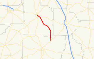
State Route 231 (SR 231) is a 20.6-mile-long (33.2 km) north-south state highway in the central part of the U.S. state of Georgia. It travels entirely within Washington County. It serves as a de facto bypass or alternate route for travelers who desired to bypass Sandersville.

U.S. Route 25 in Georgia highway in Georgia, United States

U.S. Route 25 (US 25) is a U.S. Highway that travels from Brunswick, Georgia to the Kentucky-Ohio state line, where Covington, Kentucky meets Cincinnati, Ohio at the Ohio River. In the U.S. state of Georgia, US 25 is as a 190.0-mile-long (305.8 km) highway that travels south to north in the eastern part of the state, near the Atlantic Ocean, serving Brunswick, Statesboro, and Augusta on its path from Brunswick to South Carolina at the Savannah River. Its routing travels through portions of Glynn, Wayne, Long, Tattnall, Evans, Bulloch, Jenkins, Burke, and Richmond counties.

Georgia State Route 99 highway in Georgia

State Route 99 (SR 99) is a 38.9-mile-long (62.6 km) state highway that travels south-to-north through portions of Glynn and McIntosh counties in the southeastern part of the U.S. state of Georgia. The highway begins at its southern terminus at US 82/SR 520 southwest of Sterling to its northern terminus at I-95 and SR 57 in Eulonia. The Ridge in Ridgeville on SR 99 is listed on the National Register of Historic Places.

U.S. Route 76 in Georgia highway in Georgia, United States

U.S. Route 76 (US 76) is an 150.7-mile-long (242.5 km) east–west U.S. highway in the U.S. state of Georgia. It begins at the Tennessee state line, east of Lakeview, Georgia, where the roadway continues concurrent with US-41/SR-8 toward Chattanooga. It ends at the South Carolina state line, where US 76 continues toward Anderson. In Georgia, the highway travels within portions of Catoosa, Whitfield, Murray, Gilmer, Fannin, Union, Towns, and Rabun counties. It travels through North Georgia and connects Ringgold, Dalton, Chatsworth, Ellijay, Blue Ridge, Blairsville, and Clayton. Most of the highway is part of the Lookout Mountain Scenic Highway, a highway that travels through northern Georgia and through the Chattahoochee-Oconee National Forest.

Georgia State Route 103 highway in Georgia

State Route 103 (SR 103) is a 13.9-mile-long (22.4 km) state highway in the west-central part of the U.S. state of Georgia. The highway travels from a point northwest of Mulberry Grove northwest to West Point. The highway used to travel through Muscogee, Chattahoochee, and Marion counties, but was truncated through Fort Benning. Its former path was redesignated as parts of SR 137 Spur, SR 357 and SR 219.

Georgia State Route 230 highway in Georgia

State Route 230 (SR 230) is a 59.2-mile-long (95.3 km) west–east state highway in the central part of the U.S. state of Georgia. It travels in a northern arc through portions of Dooly, Pulaski, and Dodge counties.

References

  1. 1 2 3 Google (February 24, 2013). "Overview map of SR 251" (Map). Google Maps . Google. Retrieved February 24, 2013.
  2. 1 2 State Highway Department of Georgia (1948). System of State Roads (PDF) (Map). Scale not given. Atlanta: State Highway Department of Georgia. OCLC   5673161 . Retrieved February 24, 2013. (Corrected to February 28, 1948.)
  3. 1 2 State Highway Department of Georgia (1949). System of State Roads (PDF) (Map). Scale not given. Atlanta: State Highway Department of Georgia. OCLC   5673161 . Retrieved February 24, 2013. (Corrected to April 1, 1949.)
  4. "National Highway System: Georgia" (PDF). United States Department of Transportation. May 8, 2009. Retrieved February 24, 2013.
  5. State Highway Department of Georgia (1954). State Highway System and Other Principal Connection Roads (PDF) (Map). Scale not given. Atlanta: State Highway Department of Georgia. OCLC   5673161 . Retrieved February 16, 2013. (Corrected to June 1, 1954.)
  6. State Highway Department of Georgia (1955). State Highway System and Other Principal Connection Roads (PDF) (Map). Scale not given. Atlanta: State Highway Department of Georgia. OCLC   5673161 . Retrieved February 16, 2013. (Corrected to June 1, 1955.)
  7. State Highway Department of Georgia (1960). State Highway System and Other Principal Connection Roads (PDF) (Map) (1960–1961 ed.). Scale not given. Atlanta: State Highway Department of Georgia. OCLC   5673161 . Retrieved February 16, 2013. (Corrected to June 1, 1960.)
  8. State Highway Department of Georgia (1963). State Highway System and Other Principal Connection Roads (PDF) (Map). Scale not given. Atlanta: State Highway Department of Georgia. OCLC   5673161 . Retrieved February 16, 2013. (Corrected to June 1, 1963.)
  9. Georgia Department of Transportation (January 1977). Official Highway Map (PDF) (Map) (1977–1978 ed.). Scale not given. Atlanta: Georgia Department of Transportation. Retrieved February 24, 2013.
  10. Georgia Department of Transportation (January 1978). Official Highway Map (PDF) (Map) (1978-79 ed.). Scale not given. Atlanta: Georgia Department of Transportation. Retrieved February 24, 2013.

Route map: Google

KML file (edithelp)
KML is from Wikidata