Georgia State Route 264

Last updated

Georgia 264.svg

State Route 264
Bethany Church Road
Georgia state route 264 map.png
Route information
Maintained by GDOT
Length2.7 mi [1] (4.3 km)
Existed1949 [2] [3] –present
Major junctions
West endUS 78.svgGeorgia 10.svg US 78 / SR 10 southwest of Snellville
East endGeorgia 124.svg SR 124 north of Centerville
Location
Counties Gwinnett
Highway system
  • Georgia State Routes
Georgia 262.svg SR 262 SR 266 Georgia 266.svg

State Route 264 (SR 264) is a 2.7-mile-long (4.3 km) northwest-southeast state highway located in the eastern part of the Atlanta metropolitan area in the U.S. state of Georgia. Its route is entirely within Gwinnett County.

Atlanta metropolitan area Metropolitan area in Georgia, United States

Metro Atlanta, designated by the United States Office of Management and Budget as the Atlanta–Sandy Springs–Roswell, GA Metropolitan Statistical Area, is the most populous metro area in the US state of Georgia and the ninth-largest metropolitan statistical area (MSA) in the United States. Its economic, cultural and demographic center is Atlanta, and has an estimated 2017 population of 5,884,736 according to the U.S. Census Bureau. The metro area forms the core of a broader trading area, the Atlanta–Athens-Clarke–Sandy Springs Combined Statistical Area. The Combined Statistical Area spans up to 39 counties in north Georgia and has an estimated 2017 population of 6,555,956. Atlanta is considered a "beta(+) world city." It is the third largest metropolitan region in the Census Bureau's Southeast region behind Greater Washington and Greater Miami.

Georgia (U.S. state) State of the United States of America

Georgia is a state in the Southeastern United States. It began as a British colony in 1733, the last and southernmost of the original Thirteen Colonies to be established. Named after King George II of Great Britain, the Province of Georgia covered the area from South Carolina south to Spanish Florida and west to French Louisiana at the Mississippi River. Georgia was the fourth state to ratify the United States Constitution, on January 2, 1788. In 1802–1804, western Georgia was split to the Mississippi Territory, which later split to form Alabama with part of former West Florida in 1819. Georgia declared its secession from the Union on January 19, 1861, and was one of the original seven Confederate states. It was the last state to be restored to the Union, on July 15, 1870. Georgia is the 24th largest and the 8th most populous of the 50 United States. From 2007 to 2008, 14 of Georgia's counties ranked among the nation's 100 fastest-growing, second only to Texas. Georgia is known as the Peach State and the Empire State of the South. Atlanta, the state's capital and most populous city, has been named a global city. Atlanta's metropolitan area contains about 55% of the population of the entire state.

Gwinnett County, Georgia County in the United States

Gwinnett County is a county in the north central portion of the U.S. state of Georgia. As of 2017, the population is estimated to be 920,260, making it the second-most populous county in Georgia. Its county seat is Lawrenceville. The county is named for Button Gwinnett, one of the signatories of the Declaration of Independence.

Contents

Route description

SR 264 begins at an intersection with US 78/SR 10 (Stone Mountain Highway) southwest of Snellville. Here, the roadway continues as Killian Hill Road SW. Just after its western terminus, the route runs along the west side of the Mountain View Village Shopping Center. South of the shopping center is Shiloh Road, which leads to Shiloh Elementary School, Shiloh Middle School, and Shiloh High School. The road curves to the southeast and crosses Jacks Creek. Southeast of that crossing is Centerville Public Library. SR 264 continues to the southeast, until it meets its eastern terminus, an intersection with SR 124 (Centerville Highway) north of Centerville. At its eastern terminus, the roadway continues as Zoar Road SW. The route is known as Bethany Church Road for its entire length. [1]

Intersection (road) A road junction where two or more roads either meet or cross at grade

An intersection is an at-grade junction where two or more roads meet or cross. Intersections may be classified by number of road segments, traffic controls, and/or lane design.

U.S. Route 78 in Georgia highway in Georgia, United States

U.S. Route 78 (US 78) is a 233.3-mile-long (375.5 km) U.S. Highway in the U.S. state of Georgia. It travels west to east in the north-central part of the state, starting at the Alabama state line, west of Tallapoosa, where the roadway continues concurrent with the unsigned highway Alabama State Route 4. This is also the western terminus of Georgia State Route 8 (SR 8), which is concurrent with US 78 to the east. The highway serves the Atlanta, Athens, and Augusta metropolitan areas on its path from the Alabama state line to the South Carolina state line, at the Savannah River, on the northeastern edge of Augusta, where it continues concurrent with US 1/US 25/US 278/SC 121. This is also the eastern terminus of SR 10 and the northern terminus of SR 121, as well as the southern terminus of SC 121. US 78 travels through portions of Haralson, Carroll, Douglas, Cobb, Fulton, DeKalb, Gwinnett, Walton, Oconee, Clarke, Oglethorpe, Wilkes, McDuffie, Columbia, and Richmond counties.

Georgia State Route 10 highway in Georgia

State Route 10 (SR 10) is a 172.3-mile-long (277.3 km) state highway in the U.S. state of Georgia. It travels from Downtown Atlanta to the South Carolina state line in Augusta. This highway, along with U.S. Route 78 (US 78), connect three of the biggest metro areas of the state together: Atlanta, Athens, and Augusta. It travels concurrently with US 78 in three sections: from Atlanta to Druid Hills; from near Stone Mountain to near Athens; and from Athens to its eastern terminus, for a total of 149.2 miles (240.1 km), or approximately 86.6 percent of its route.

No section of SR 264 is part of the National Highway System, a system of routes determined to be the most important for the nation's economy, mobility and defense. [4]

National Highway System (United States) highway system in the United States

The National Highway System (NHS) is a network of strategic highways within the United States, including the Interstate Highway System and other roads serving major airports, ports, rail or truck terminals, railway stations, pipeline terminals and other strategic transport facilities. Altogether, it constitutes the largest highway system in the world.

History

SR 264 was established in 1949 along the same alignment as it travels today. [2] [3] By 1955, the entire route was paved. [5] [6]

Major intersections

The entire route is in Gwinnett County.

Locationmi [1] kmDestinationsNotes
0.00.0US 78.svgGeorgia 10.svg US 78 / SR 10 (Stone Mountain Highway) Stone Mountain, Snellville, Decatur, Atlanta Western terminus; roadway continues as Killian Hill Road SW.
2.74.3Georgia 124.svg SR 124 (Centerville Highway) Centerville, Snellville Eastern terminus; roadway continues as Zoar Road SW.
1.000 mi = 1.609 km; 1.000 km = 0.621 mi

See also

Related Research Articles

Interstate 985 (I-985) is a 25.01-mile-long (40.25 km) Auxiliary Interstate Highway in the northeastern part of the U.S. state of Georgia. It links the Atlanta metropolitan area to the city of Gainesville via Suwanee. I-985 is also known as the Sidney Lanier Parkway and is also designated as unsigned State Route 419. The roadway was designated as I-985 in 1985.

Georgia State Route 20 highway in Georgia

State Route 20 (SR 20) is a 165.345-mile-long (266.097 km) state highway roughly in the shape of a capital J rotated ninety degrees to the left, which travels through portions of Floyd, Bartow, Cherokee, Forsyth, Gwinnett, Walton, Rockdale, Newton, and Henry counties in the northwestern and north-central parts of the U.S. state of Georgia. Its counterclockwise, or western terminus is at the Alabama state line in Floyd County, and its clockwise, or eastern terminus occurs at its interchange with Lower Woolsey Road southwest of Hampton in Henry County south-southeast of the Atlanta Motor Speedway.

Georgia State Route 120 highway in Georgia

State Route 120 (SR 120) is a 90.7-mile-long (146.0 km) state highway that runs west-to-east through portions of Haralson, Paulding, Cobb, Fulton, and Gwinnett counties in northwestern part of the U.S. state of Georgia.

Georgia State Route 300 highway in Georgia

State Route 300, is a 107-mile-long (172 km) state highway in the southern part of the U.S. state of Georgia. Its southern terminus is at the Florida state line south-southeast of Thomasville, where the roadway continues as US 19/SR 57. This is also the southern terminus of SR 3, with which US 19 and SR 300 travel concurrently through the southern part of the state. Its northern terminus is at Interstate 75 (I-75) in Cordele.

Georgia State Route 365 highway in Georgia

State Route 365 (SR 365) is a 69.5-mile-long (111.8 km) state highway that travels within portions of Gwinnett, Hall, Habersham, and Stephens counties. It begins at exit 113 on Interstate 85 (I-85), at the southeastern edge of Suwanee. This is also the southern terminus of I-985. It continues from that point concurrent with I-985 for the entire length of that freeway. Eventually, U.S. Route 23 (US 23) also joins the concurrency. The highway heads northeast through Gainesville and Toccoa, before it terminates at the South Carolina state line, southwest of Westminster, South Carolina.

Georgia State Route 378 highway in Georgia

State Route 378 (SR 378) is a 6.4-mile-long (10.3 km), four-lane state highway that travels west-to-east entirely within Gwinnett County in the north-central part of the U.S. state of Georgia. The route is heavily commercialized with numerous office and industrial parks. It is known along its entire length as Beaver Ruin Road. The roadway was built in the mid-1960s and designated a decade later.

Georgia State Route 28 highway in Georgia

State Route 28 (SR 28) is a 25.7-mile-long (41.4 km) state highway in the U.S. state of Georgia. It exists in two distinct segments separated by the northern segment of South Carolina Highway 28 (SC 28), which connects the two segments. The northern segment is located in the northeastern corner of the Chattooga River District of the Chattahoochee-Oconee National Forest. The southern segment is entirely within the Augusta metropolitan area. SR 28 consists of Georgia's segments of a multi-state Route 28 that includes one segment of North Carolina Highway 28 (NC 28) and two segments of SC 28. The northern segment of SR 28 is unnamed, but the southern segment is known as Furys Ferry Road from its western terminus to the intersection with SR 104 Conn. in Augusta, Washington Road in the northern part of Augusta, John C. Calhoun Expressway, Greene Street, 5th Street, and Broad Street in downtown Augusta, and Sand Bar Ferry Road in the northeastern part of Augusta.

Georgia State Route 8 highway in Georgia

State Route 8 (SR 8) is a 183-mile-long (295 km) state highway that travels west-to-east through portions of Haralson, Carroll, Douglas, Cobb, Fulton, DeKalb, Gwinnett, Barrow, Clarke, Oconee, Madison, Franklin, and Hart counties, bisecting the northern part of the U.S. state of Georgia. The highway travels from its western terminus at US 78 and SR 4 at the Alabama state line west of Tallapoosa to its eastern terminus at US 29 at the South Carolina state line at the south end of Lake Hartwell. The highway is concurrent with either US 29 or US 78 for its entire length.

Georgia State Route 36 highway in Georgia

State Route 36 (SR 36) is a 95.2-mile-long (153.2 km) state highway that travels southwest-to-northeast through portions of Harris, Talbot, Upson, Lamar, Butts, and Newton counties in the central part of the U.S. state of Georgia. The highways connects the Waverly Hall area with Covington, via Thomaston, Barnesville, and Jackson.

Georgia State Route 51 highway in Georgia

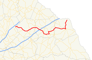
State Route 51 (SR 51) is a 63.6-mile-long (102.4 km) state highway that travels west-to-east through portions of Hall, Banks, Franklin, and Hart counties in the northeastern part of the U.S. state of Georgia. The highway connects Lula with Lake Hartwell, via Homer, Carnesville, and Hartwell.

Georgia State Route 272 highway in Georgia

State Route 272 (SR 272) is a 15.4-mile-long (24.8 km) north–south state highway located in the east-central part of the U.S. state of Georgia. Its path is entirely within Washington County.

Georgia State Route 271 highway in Georgia

State Route 271 (SR 271) is a 7.6-mile-long (12.2 km) east–west state highway located in the west-central part of the U.S. state of Georgia. Its route is within Schley and Sumter counties.

Georgia State Route 270 highway in Georgia

State Route 270 (SR 270) is a 12.7-mile-long (20.4 km) east–west state highway located in the southern part of the U.S. state of Georgia. Its route is within Mitchell and Colquitt counties.

Georgia State Route 268 highway in Georgia

State Route 268 (SR 268) is a 22.9-mile-long (36.9 km) southwest–northeast state highway located in the south-central part of the U.S. state of Georgia. It travels within portions of Coffee and Jeff Davis counties.

Georgia State Route 262 highway in Georgia

State Route 262 (SR 262) is a 44.4-mile-long (71.5 km) L-shaped state highway located in the southwestern part of the U.S. state of Georgia. It travels within portions of within Decatur and Mitchell counties, and skims the border of Grady County.

Georgia State Route 254 highway in Georgia

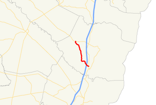
State Route 254 (SR 254) is a 10.8-mile-long (17.4 km) southwest-northeast state highway located in the northeastern part of the U.S. state of Georgia. It travels through portions of Hall and White counties.

Georgia State Route 251 highway in Georgia

State Route 251 (SR 251) is a 13.5-mile-long (21.7 km) south–north state highway located in the east-central part of the U.S. state of Georgia. It travels entirely within McIntosh County.

Georgia State Route 60 highway in Georgia

State Route 60 (SR 60) is a 90.1-mile-long (145.0 km) state highway that travels southeast-to-northwest through portions of Jackson, Hall, Lumpkin, Union, and Fannin counties in the north-central part of the U.S. state of Georgia. The highway connects the Braselton area with McCaysville at the Tennessee state line, via Gainesville and Dahlonega.

Georgia State Route 242 highway in Georgia

State Route 242 (SR 242) is a 25.0-mile-long (40.2 km) east–west state highway located in the central part of the U.S. state of Georgia. It travels through portions of Washington and Jefferson counties.

Georgia State Route 98 highway in Georgia

State Route 98 (SR 98) is a 36.6-mile-long (58.9 km) state highway that travels southeast-to-northwest through portions of Madison, Jackson, and Banks counties in the northeastern part of the U.S. state of Georgia. The highway connects Comer and Homer, via Danielsville, Commerce, and Maysville.

References

  1. 1 2 3 Google (February 19, 2013). "Overview map of SR 264" (Map). Google Maps . Google. Retrieved February 19, 2013.
  2. 1 2 State Highway Department of Georgia (1948). System of State Roads (PDF) (Map). Scale not given. Atlanta: State Highway Department of Georgia. OCLC   5673161 . Retrieved February 19, 2013. (Corrected to February 28, 1948.)
  3. 1 2 State Highway Department of Georgia (1949). System of State Roads (PDF) (Map). Scale not given. Atlanta: State Highway Department of Georgia. OCLC   5673161 . Retrieved February 19, 2013. (Corrected to April 1, 1949.)
  4. "National Highway System: Georgia" (PDF). United States Department of Transportation. May 8, 2009. Retrieved February 19, 2013.
  5. State Highway Department of Georgia (1954). State Highway System and Other Principal Connecting Roads (PDF) (Map). Scale not given. Atlanta: State Highway Department of Georgia. OCLC   5673161 . Retrieved February 19, 2013. (Corrected to June 1, 1954.)
  6. State Highway Department of Georgia (1955). State Highway System and Other Principal Connecting Roads (PDF) (Map). Scale not given. Atlanta: State Highway Department of Georgia. OCLC   5673161 . Retrieved February 19, 2013. (Corrected to June 1, 1955.)

Route map:

KML file (edithelp)
    KML is from Wikidata