Georgia State Route 266

Last updated

Georgia 266.svg

State Route 266
Georgia state route 266 map.png
Route information
Maintained by GDOT
Length 18.2 mi [1] (29.3 km)
Existed 1950 [2] [3] – present
Major junctions
West endGeorgia 39.svg SR 39 north of Fort Gaines
East endUS 82.svgGeorgia 50.svg US 82 / SR 50 southwest of Cuthbert
Location
Counties Clay, Randolph
Highway system
  • Georgia State Routes
Georgia 264.svg SR 264 SR 268 Georgia 268.svg

State Route 266 (SR 266) is a west-east state highway located in the southwestern part of the U.S. state of Georgia. Its route is within Clay and Randolph counties.

A state highway, state road, or state route is usually a road that is either numbered or maintained by a sub-national state or province. A road numbered by a state or province falls below numbered national highways in the hierarchy. Roads maintained by a state or province include both nationally numbered highways and un-numbered state highways. Depending on the state, "state highway" may be used for one meaning and "state road" or "state route" for the other.

Southwest Georgia

Southwest Georgia is a fourteen-county region in the U.S. state of Georgia. It has a 2010 census population of 496,433, and is the least populated region in Georgia, just slightly behind Southeast Georgia. Additionally, the area has historically been the poorest region of the state since at least 1995, when over 25% of the residents were in poverty.

U.S. state constituent political entity of the United States

In the United States, a state is a constituent political entity, of which there are currently 50. Bound together in a political union, each state holds governmental jurisdiction over a separate and defined geographic territory and shares its sovereignty with the federal government. Due to this shared sovereignty, Americans are citizens both of the federal republic and of the state in which they reside. State citizenship and residency are flexible, and no government approval is required to move between states, except for persons restricted by certain types of court orders. Four states use the term commonwealth rather than state in their full official names.

Contents

Route description

SR 266 begins at an intersection with SR 39 about 2 miles (3.2 km) north of Fort Gaines. SR 39 north leads to George T. Bagby State Park. The route heads northeast through rural parts of Clay County to Clay County Road 43 (Cotton Hill Road). Later on is CR 47 (Shaw Road). Farther to the northeast is CR 44 (Bethel Church Road). After that, the county crosses a corner of Randolph County before re-entering Clay County for a short while. Back in Randolph County, the route heads to Coleman, where it intersects Randolph CR 160 (Hangman Road). Just to the northwest is CR 33 (Chestnut Street), then CR 67 and CR 65 (Hammock Road). Northeast of Coleman is CR 66 (Hammock Road). Then is CR 17 (Mitchell Grove Road). Then, the highway encounters CR 32 (Lee Knighton Road). SR 266 eventually gets to the unincorporated community of Coles, where it intersects Cotton Hill Road (a different one from near the western terminus of SR 266), which leads to the unincorporated community of Days Crossroads. Just before reaching its eastern terminus, an intersection with US 82/SR 50 southwest of Cuthbert, the highway crosses a Central of Georgia Railway line. [1]

Intersection (road) A road junction where two or more roads either meet or cross at grade

An intersection is an at-grade junction where two or more roads meet or cross. Intersections may be classified by number of road segments, traffic controls, and/or lane design.

Georgia State Route 39 highway in Georgia

State Route 39 is a 118-mile-long (190 km) state highway that travels south-to-north through portions of Seminole, Miller, Early, Clay, Quitman, and Stewart counties in the southwestern part of the U.S. state of Georgia. The route proceeds north from its southern terminus along the shore of Lake Seminole in southern Seminole County to a point just southwest of Omaha, where it travels in an easterly direction until it meets its northern terminus, an intersection with US 27/SR 1 in the unincorporated community of Louvale Station.

Fort Gaines, Georgia City in Georgia, United States

Fort Gaines is a city in Georgia, United States, with a population of 1,107 at the 2010 census. The city is the county seat of Clay County.

There is no section of SR 266 that is included as a part of the National Highway System. [4]

National Highway System (United States) highway system in the United States

The National Highway System (NHS) is a network of strategic highways within the United States, including the Interstate Highway System and other roads serving major airports, ports, rail or truck terminals, railway stations, pipeline terminals and other strategic transport facilities. Altogether, it constitutes the largest highway system in the world.

History

SR 266 was established in 1950 along an alignment from Bellville north to Coleman, and then northeast from Coleman to its eastern terminus as it runs today. The section from about Coleman east was paved at this time. [2] [3] By 1952, the entire Bellville-eastern terminus section was paved. [3] [5] By 1975, the road was moved, and paved, to its current alignment, with the former section from Bellville to Coleman being redesignated as Clay County Road 131, Randolph County Road 160, and Randolph County Road 62. [1] [6] [7]

Bellville, Georgia City in Georgia, United States

Bellville is a city in Evans County, Georgia, United States. As of the 2010 census, the city had a population of 123. It is home to Pinewood Christian Academy and is the hometown of writer/director James Kicklighter.

Major intersections

CountyLocationmi [1] kmDestinationsNotes
Clay 0.00.0Georgia 39.svg SR 39 (Eufaula Street) Fort Gaines, Eufaula Western terminus
Randolph
No major junctions
Clay
No major junctions
Randolph 18.229.3US 82.svgGeorgia 50.svg US 82 / SR 50 (College Street)Eastern terminus
1.000 mi = 1.609 km; 1.000 km = 0.621 mi

See also

Related Research Articles

Interstate 985 (I-985) is a 25.01-mile-long (40.25 km) Auxiliary Interstate Highway in the northeastern part of the U.S. state of Georgia. It links the Atlanta metropolitan area to the city of Gainesville via Suwanee. I-985 is also known as the Sidney Lanier Parkway and is also designated as unsigned State Route 419. The roadway was designated as I-985 in 1985.

Georgia State Route 20 highway in Georgia

State Route 20 (SR 20) is a 165.345-mile-long (266.097 km) state highway roughly in the shape of a capital J rotated ninety degrees to the left, which travels through portions of Floyd, Bartow, Cherokee, Forsyth, Gwinnett, Walton, Rockdale, Newton, and Henry counties in the northwestern and north-central parts of the U.S. state of Georgia. Its counterclockwise, or western terminus is at the Alabama state line in Floyd County, and its clockwise, or eastern terminus occurs at its interchange with Lower Woolsey Road southwest of Hampton in Henry County south-southeast of the Atlanta Motor Speedway.

Georgia State Route 120 highway in Georgia

State Route 120 (SR 120) is a 90.7-mile-long (146.0 km) state highway that runs west-to-east through portions of Haralson, Paulding, Cobb, Fulton, and Gwinnett counties in northwestern part of the U.S. state of Georgia.

Georgia State Route 300 highway in Georgia

State Route 300, is a 107-mile-long (172 km) state highway in the southern part of the U.S. state of Georgia. Its southern terminus is at the Florida state line south-southeast of Thomasville, where the roadway continues as US 19/SR 57. This is also the southern terminus of SR 3, with which US 19 and SR 300 travel concurrently through the southern part of the state. Its northern terminus is at Interstate 75 (I-75) in Cordele.

Georgia State Route 233 highway in Georgia

State Route 233 (SR 233) is a 19.4-mile-long (31.2 km) north–south state highway in the central part of the U.S. state of Georgia. It travels through portions of Ben Hill and Wilcox counties.

State Route 2 (SR 2) is a 165-mile-long (266 km) east-west state highway in the far northern part of the U.S. state of Georgia. The highway serves southern suburbs of Chattanooga, Tennessee, as well as much of the mountainous area in the northern part of the state. It traverses the counties of Walker, Catoosa, Whitfield, Murray, Gilmer, Fannin, Union, Towns, and Rabun. It connects Flintstone, in the northwestern part of the state, with the South Carolina state line southeast of Clayton in the northern part and the northeastern part of the state. It also travels through Fort Oglethorpe, Ringgold, Ellijay, Blue Ridge, Blairsville, and Hiawassee. Parts of the highway in the Whitfield and Murray county area are designated as the Cohutta–Chattahoochee Scenic Byway.

Georgia State Route 36 highway in Georgia

State Route 36 (SR 36) is a 95.2-mile-long (153.2 km) state highway that travels southwest-to-northeast through portions of Harris, Talbot, Upson, Lamar, Butts, and Newton counties in the central part of the U.S. state of Georgia. The highways connects the Waverly Hall area with Covington, via Thomaston, Barnesville, and Jackson.

Georgia State Route 43 highway in Georgia

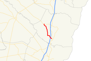
State Route 43 (SR 43) is a 25.7-mile-long (41.4 km) state highway that travels southwest-to-northeast through portions of McDuffie and Lincoln counties in the east-central part of the U.S. state of Georgia. The highway connects the northern part of the Thomson area to the South Carolina state line, via Lincolnton.

Georgia State Route 270 highway in Georgia

State Route 270 (SR 270) is a 12.7-mile-long (20.4 km) east–west state highway located in the southern part of the U.S. state of Georgia. Its route is within Mitchell and Colquitt counties.

Georgia State Route 268 highway in Georgia

State Route 268 (SR 268) is a 22.9-mile-long (36.9 km) southwest–northeast state highway located in the south-central part of the U.S. state of Georgia. It travels within portions of Coffee and Jeff Davis counties.

Georgia State Route 262 highway in Georgia

State Route 262 (SR 262) is a 44.4-mile-long (71.5 km) L-shaped state highway located in the southwestern part of the U.S. state of Georgia. It travels within portions of within Decatur and Mitchell counties, and skims the border of Grady County.

Georgia State Route 254 highway in Georgia

State Route 254 (SR 254) is a 10.8-mile-long (17.4 km) southwest-northeast state highway located in the northeastern part of the U.S. state of Georgia. It travels through portions of Hall and White counties.

Georgia State Route 251 highway in Georgia

State Route 251 (SR 251) is a 13.5-mile-long (21.7 km) south–north state highway located in the east-central part of the U.S. state of Georgia. It travels entirely within McIntosh County.

Georgia State Route 243 highway in Georgia

State Route 243 (SR 243) was a 21.2-mile-long (34.1 km) north–south state highway located in the central part of the U.S. state of Georgia. It existed in portions of Wilkinson and Baldwin counties.

Georgia State Route 241 highway in Georgia

State Route 241 (SR 241) is a 5.6-mile-long (9.0 km) southwest-northeast state highway located in the southwestern part of the U.S. state of Georgia. It exists entirely within Decatur County.

Georgia State Route 234 highway in Georgia

State Route 234 (SR 234) is a 28.3-mile-long (45.5 km) east–west state highway located in the southwestern part of the U.S. state of Georgia. It travels through portions of Calhoun and Dougherty counties.

Georgia State Route 231 highway in Georgia

State Route 231 (SR 231) is a 20.6-mile-long (33.2 km) north-south state highway in the central part of the U.S. state of Georgia. It travels entirely within Washington County. It serves as a de facto bypass or alternate route for travelers who desired to bypass Sandersville.

Georgia State Route 223 highway in Georgia

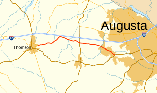
State Route 223 (SR 223) is a 20.9-mile-long (33.6 km) east–west state highway in the east-central part of the U.S. state of Georgia. Its routing travels through portions of McDuffie, Columbia, and Richmond counties. The highway connects Thomson with Grovetown, Augusta, and Fort Gordon. Except for the portions in Thomson, Grovetown, and Augusta, the highway is relatively rural.

Georgia State Route 227 highway in Georgia

State Route 227 (SR 227) is a 2.2-mile-long (3.5 km) connecting state highway that travels south-to-north through portions of Treutlen County in the east-central part of the U.S. state of Georgia.

Georgia State Route 230 highway in Georgia

State Route 230 (SR 230) is a 59.2-mile-long (95.3 km) west–east state highway in the central part of the U.S. state of Georgia. It travels in a northern arc through portions of Dooly, Pulaski, and Dodge counties.

References

  1. 1 2 3 4 Google (February 18, 2013). "Route of SR 266" (Map). Google Maps . Google. Retrieved February 18, 2013.
  2. 1 2 Georgia State Highway System (PDF) (Map). Cartography by GSHD. Georgia State Highway Department. April 1, 1949. Retrieved February 18, 2013.[ permanent dead link ]
  3. 1 2 3 Georgia State Highway System (PDF) (Map). Cartography by GSHD. Georgia State Highway Department. August 1, 1950. Retrieved February 18, 2013.[ permanent dead link ]
  4. "National Highway System: Georgia" (PDF). United States Department of Transportation. May 8, 2009. Retrieved February 18, 2013.
  5. Georgia State Highway System (PDF) (Map). Cartography by GSHD. Georgia State Highway Department. January 1, 1952. Retrieved February 18, 2013.[ permanent dead link ]
  6. Georgia State Highway System (PDF) (Map). Cartography by GSHD. Georgia State Highway Department. January 1, 1973. Retrieved February 18, 2013.[ permanent dead link ]
  7. Georgia State Highway System (PDF) (Map). Cartography by GSHD. Georgia State Highway Department. January 1, 1974-5. Retrieved February 18, 2013.Check date values in: |date= (help)[ permanent dead link ]
KML file (edithelp)
KML is not from Wikidata