Georgia State Route 288

Last updated

Georgia 288.svg

State Route 288
Sunnyside Road
Georgia state route 288 map.png
Route information
Maintained by GDOT
Length 5.8 mi [1] (9.3 km)
Major junctions
Northwest endUS 76.svgGeorgia 2.svgGeorgia 17.svg US 76 / SR 2 / SR 17 west of Hiawassee
Southeast endUS 76.svgGeorgia 2.svgGeorgia 17.svgGeorgia 75.svg US 76 / SR 2 / SR 17 / SR 75 southeast of Hiawassee
Location
Counties Towns
Highway system
  • Georgia State Routes
Georgia 287.svg SR 287 SR 292 Georgia 292.svg

State Route 288 (SR 288) is a northwest-southeast state highway located in the northeast part of the U.S. state of Georgia. Its route is entirely within Towns County.

A state highway, state road, or state route is usually a road that is either numbered or maintained by a sub-national state or province. A road numbered by a state or province falls below numbered national highways in the hierarchy. Roads maintained by a state or province include both nationally numbered highways and un-numbered state highways. Depending on the state, "state highway" may be used for one meaning and "state road" or "state route" for the other.

Northeast Georgia

Northeast Georgia is a region of Georgia in the United States. The northern part is also in the north Georgia mountains, while the southern part is still hilly but much flatter in topography. Northeast Georgia is also served by the Asheville/Spartanburg/Greenville/Anderson market.

U.S. state constituent political entity of the United States

In the United States, a state is a constituent political entity, of which there are currently 50. Bound together in a political union, each state holds governmental jurisdiction over a separate and defined geographic territory and shares its sovereignty with the federal government. Due to this shared sovereignty, Americans are citizens both of the federal republic and of the state in which they reside. State citizenship and residency are flexible, and no government approval is required to move between states, except for persons restricted by certain types of court orders. Four states use the term commonwealth rather than state in their full official names.

Contents

Route description

SR 288 begins at an intersection with US 76/SR 2/SR 17 west of Hiawassee. The route runs southeast, then northeast, then southeast again, before turning east to meet its eastern terminus, an intersection with US 76/SR 2/SR 17/SR 75 southeast of Hiawassee. Parts of the highway hug the southwestern shore of Lake Chatuge, and the highway provides access to the Lake Chatuge Recreation Area. The route serves as a functional bypass route for US 76 around Hiawassee, although it is longer than taking US 76 through downtown. The route is known as Sunnyside Road for its entire length.

Intersection (road) A road junction where two or more roads either meet or cross at grade

An intersection is an at-grade junction where two or more roads meet or cross. Intersections may be classified by number of road segments, traffic controls, and/or lane design.

U.S. Route 76 in Georgia highway in Georgia, United States

U.S. Route 76 (US 76) is an 150.7-mile-long (242.5 km) east–west U.S. highway in the U.S. state of Georgia. It begins at the Tennessee state line, east of Lakeview, Georgia, where the roadway continues concurrent with US-41/SR-8 toward Chattanooga. It ends at the South Carolina state line, where US 76 continues toward Anderson. In Georgia, the highway travels within portions of Catoosa, Whitfield, Murray, Gilmer, Fannin, Union, Towns, and Rabun counties. It travels through North Georgia and connects Ringgold, Dalton, Chatsworth, Ellijay, Blue Ridge, Blairsville, and Clayton. Most of the highway is part of the Lookout Mountain Scenic Highway, a highway that travels through northern Georgia and through the Chattahoochee-Oconee National Forest.

State Route 2 (SR 2) is a 165-mile-long (266 km) east-west state highway in the far northern part of the U.S. state of Georgia. The highway serves southern suburbs of Chattanooga, Tennessee, as well as much of the mountainous area in the northern part of the state. It traverses the counties of Walker, Catoosa, Whitfield, Murray, Gilmer, Fannin, Union, Towns, and Rabun. It connects Flintstone, in the northwestern part of the state, with the South Carolina state line southeast of Clayton in the northern part and the northeastern part of the state. It also travels through Fort Oglethorpe, Ringgold, Ellijay, Blue Ridge, Blairsville, and Hiawassee. Parts of the highway in the Whitfield and Murray county area are designated as the Cohutta–Chattahoochee Scenic Byway.

History

Major intersections

The entire route is in Towns County.

Locationmi [1] kmDestinationsNotes
0.00.0US 76.svgGeorgia 2.svgGeorgia 17.svg US 76 / SR 2 / SR 17 Western terminus
Lake Chatuge 5.38.5Crossing over Lake Chatuge
5.89.3US 76.svgGeorgia 2.svgGeorgia 17.svgGeorgia 75.svg US 76 / SR 2 / SR 17 / SR 75 Eastern terminus
1.000 mi = 1.609 km; 1.000 km = 0.621 mi

See also

Related Research Articles

Georgia State Route 42 highway in Georgia

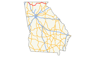
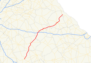
State Route 42 (SR 42) is a 115.3-mile-long (185.6 km) state highway that runs southeast-to-northwest through portions of Peach, Crawford, Monroe, Butts, Henry, Clayton, and DeKalb counties in the central and north-central parts of the U.S. state of Georgia. The route connects Byron with the Atlanta metropolitan area, via McDonough, Stockbridge, and Forest Park.

Georgia State Route 515 highway in Georgia

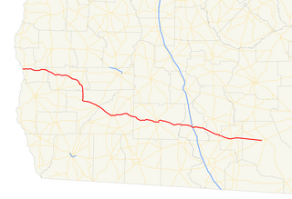
State Route 515 (SR 515) is a 76.2-mile-long (122.6 km) four-lane C-shaped state highway in the northern part of the U.S. state of Georgia. It begins just west of Nelson. It curves to the northeast to Lake Chatuge, where it heads north to the North Carolina state line. The highway was built to give motorists in the north Georgia mountains better access to Atlanta and its outlying suburbs, as opposed to the old SR 5 and U.S. Route 76 (US 76) highways, which this project replaced. SR 515 is also known as the Zell Miller Mountain Parkway, in honor of Zell Miller, the Young Harris native turned Georgia governor and U.S. senator. It is one of the Georgia Department of Transportation's Governor's Road Improvement Program (GRIP) corridors. The highway is known for its mountain views all along its route. SR 515 is part of the Appalachian Development Highway System's Corridor A, and is known as the "APD Highway." The highway was designated in 1989.

Georgia State Route 376 highway in Georgia

State Route 376 (SR 376) is a 16.0-mile-long (25.7 km) east–west state highway that travels within portions of Lowndes and Echols counties in the southern part of the U.S. state of Georgia. It connects Clyattville with the Statenville area, via Lake Park. The roadway was built in the late 1950s and designated as SR 376 in 1972.

Georgia State Route 380 highway in Georgia

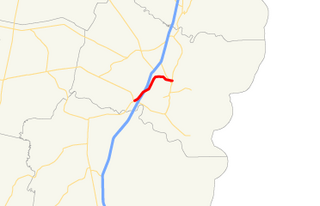
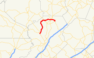
State Route 380 (SR 380) is a 5.8-mile-long (9.3 km) state highway that travels west-to-east in a southern arc entirely within Jasper County in the central part of the U.S. state of Georgia. The highway acts as a partial bypass of Monticello.

Georgia State Route 325 highway in Georgia

State Route 325 (SR 325) is an arc-shaped 11.1-mile-long (17.9 km) state highway completely within the Chattahoochee-Oconee National Forest in Union County in the extreme northern part of the U.S. state of Georgia. It hugs the western and northern shores of Lake Nottely, and is known as Nottely Dam Road for its entire length.

Georgia State Route 307 highway in Georgia

State Route 307 (SR 307) is a south-north state highway located in the east central part of the U.S. state of Georgia. The route runs entirely within the Savannah metropolitan area and Chatham County.

Georgia State Route 303 highway in Georgia

State Route 303 (SR 303) is a 9.1-mile-long (14.6 km) south–north state highway in the southeast part of the U.S. state of Georgia. It travels completely within Glynn County, and is in the Brunswick metropolitan area.

Georgia State Route 17 highway in Georgia

State Route 17 (SR 17) is a 294-mile-long (473 km) state highway that travels south-to-north through portions of Chatham, Effingham, Screven, Jenkins, Burke, Jefferson, Warren, McDuffie, Wilkes, Elbert, Hart, Franklin, Stephens, Habersham, White, and Towns counties in the east-central and northeastern parts of the U.S. state of Georgia. The highway connects Interstate 16 (I-16) in Bloomingdale to the North Carolina state line, northwest of Hiawassee, via Millen, Louisville, Wrens, Thomson, Washington, Elberton, Royston, Toccoa, Clarkesville, and Hiawassee.

Georgia State Route 75 highway in Georgia

State Route 75 (SR 75) is a 33.4-mile-long (53.8 km) state highway that runs south-to-north through portions of White and Towns counties in the northern part of the U.S. state of Georgia. It connects the towns of Cleveland and Hiawassee with Helen, Macedonia, and the North Carolina state line.

Georgia State Route 37 highway in Georgia

State Route 37 (SR 37) is a 153.6-mile-long (247.2 km) state highway that travels west-to-east through portions of Clay, Calhoun, Baker, Mitchell, Colquitt, Cook, Berrien, Lanier, and Clinch counties in the southwestern and south-central parts of the U.S. state of Georgia. The highway connects the Alabama state line west of Fort Gaines to the Homerville area, via Newton, Camilla, Moultrie, Adel, and Lakeland.

Georgia State Route 44 highway in Georgia

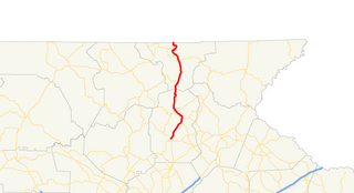
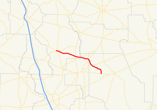
State Route 44 (SR 44) is a 94.2-mile-long (151.6 km) state highway that runs southwest-to-northeast through portions of Jones, Putnam, Greene, Taliaferro, Wilkes, and Lincoln counties in the central and east-central parts of the U.S. state of Georgia. The route connects Gray with the central portion of Lincoln County, northwest of Lincolnton.

Georgia State Route 283 highway in Georgia

State Route 283 (SR 283) is a south-north state highway that runs in a wide arc in the northeastern part of the U.S. state of Georgia. Its route is located entirely within Hall County.

Georgia State Route 262 highway in Georgia

State Route 262 (SR 262) is a 44.4-mile-long (71.5 km) L-shaped state highway located in the southwestern part of the U.S. state of Georgia. It travels within portions of within Decatur and Mitchell counties, and skims the border of Grady County.

Georgia State Route 125 highway in Georgia

State Route 125 (SR 125) is a 73-mile-long (117 km) state highway that runs south-to-north in an S-shape through the southern part of the U.S. state of Georgia. It travels through Lowndes, Lanier, Berrien, Tift, Irwin, and Ben Hill counties connecting the Valdosta and Fitzgerald metropolitan areas.

Georgia State Route 115 highway in Georgia

State Route 115 (SR 115) is a 32.3-mile-long (52.0 km) state highway that runs west-to-east in the northeastern part of the U.S. state of Georgia. It travels through portions of Lumpkin, White, and Habersham counties.

Georgia State Route 83 highway in Georgia

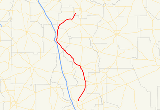
State Route 83 (SR 83) is an 86.5-mile-long (139.2 km) state highway that runs southwest to northeast, with a southeast–to–northwest section, within portions of Monroe, Jasper, Morgan, and Walton counties in the central part of the U.S. state of Georgia. It connects Forsyth, Monticello, and Madison. The portion from the southwestern city limits of Monticello to the Jasper–Morgan county line is included in the Monticello Crossroads Scenic Byway.

Georgia State Route 181 highway in Georgia

State Route 181 is a state highway in the northeastern part of the U.S. state of Georgia. It runs west–east through portions of Hart county.

Georgia State Route 168 highway in Georgia

State Route 168 (SR 168) is a state highway that runs west–east through portions of Berrien, Lanier, and Clinch counties in the south-central part of the U.S. state of Georgia.

References

  1. 1 2 Google (February 11, 2013). "Route of SR 288" (Map). Google Maps . Google. Retrieved February 11, 2013.

Route map: Google

KML file (edithelp)
KML is from Wikidata