Gerasdorf bei Wien

Last updated

Gerasdorf bei Wien
Gerasdorf bei Wien - Ortsansicht.JPG
South view of Gerasdorf bei Wien
AUT Gerasdorf COA.svg
Austria Lower Austria location map.svg
Red pog.svg
Gerasdorf bei Wien
Location within Austria
Austria Vienna location map.svg
Red pog.svg
Gerasdorf bei Wien
Gerasdorf bei Wien (Vienna)
Austria adm location map.svg
Red pog.svg
Gerasdorf bei Wien
Gerasdorf bei Wien (Austria)
Coordinates: 48°17′42″N16°28′03″E / 48.29500°N 16.46750°E / 48.29500; 16.46750 Coordinates: 48°17′42″N16°28′03″E / 48.29500°N 16.46750°E / 48.29500; 16.46750
Country Austria
State Lower Austria
District Korneuburg
Government
   Mayor Alexander Vojta (SPÖ)
Area
[1]
  Total35.26 km2 (13.61 sq mi)
Elevation
165 m (541 ft)
Population
 (2018-01-01) [2]
  Total11,155
  Density320/km2 (820/sq mi)
Time zone UTC+1 (CET)
  Summer (DST) UTC+2 (CEST)
Postal code
2201
Area code +43 2246
Vehicle registration KO
Website www.gerasdorf-wien.gv.at

Gerasdorf bei Wien is a town in the district of Korneuburg in the Austrian state of Lower Austria. The city has 10,862 inhabitants. (As of 1 January 2017)

Contents

Geography

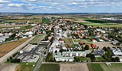
The city is located in the Weinviertel district of Lower Austria on the northern city boundary of Vienna. The area of the township covers 35.24 square kilometres, about one percent of the area is wooded.

It was the only municipality north of the Danube in Wien-Umgebung District until the district was dissolved in 2016. [3] [4]

Community classification

The municipality comprises the following two localities (population as of January 1, 2016) [5]

The municipality consists three cadastral parts:

Population

Historical population
YearPop.±%
18691,330    
18801,364+2.6%
18901,444+5.9%
19001,526+5.7%
19101,733+13.6%
19231,759+1.5%
19342,455+39.6%
19393,485+42.0%
19513,466−0.5%
19613,947+13.9%
19714,728+19.8%
19815,279+11.7%
19916,661+26.2%
20018,231+23.6%
201110,156+23.4%
202111,666+14.9%

Politics

Since March 11, 2008 Alexander Vojta (SPÖ) is mayor of the city community. Because of the formation of the first SPÖ / ÖVP coalition in the municipality (March 2015) Lukas Mandl (ÖVP) is deputy mayor. The municipal director is Herbert Klenk. In the municipal council, the following mandate distribution takes place in a total of 37 seats following the municipal elections of 25 January 2015: [6]

History

After the "Anschluss" of Austria to the Third Reich the place was integrated into "Groß-Wien" in the autumn of 1938. In 1954 Gerasdorf was one of the 80 Viennese municipalities, which were reorganized to the state of Lower Austria.

In 1972, the municipality of Seyring was integrated into the municipality of Gerasdorf. In May 1992, Gerasdorf became a market town. On 17 December 1998, the Lower Austrian Parliament decided to extend the town of Gerasdorf.

The two settlements of Oberlisse and Kapellerfeld originated in the inter-war period after 1918. The name Kapellerfeld refers to a settlement which was already abandoned in 1258 as "Capellen", which was later abandoned and which was located half a kilometre south of today's settlement.

In September 2015, it was announced that the district of Wien Umgebung would be dissolved by December 31, 2016. In an online citizens' survey (September 2015) a two-thirds majority voted for membership of the Korneuburg district. In this vote Mistelbach and Gänserndorf were the other options. [7]

Religions

In Gerasdorf there are several Roman Catholic parishes (with Oberlisse and Kapellerfeld) and Seyring. From 1953 to 1965 Kurt Knotzinger was chaplain and priest in Gerasdorf. There is also an evangelical church in Gerasdorf and in Kapellerfeld.

Economy and Infrastructure

The most important economic factor is undoubtedly the shopping centre "G3 Shopping Ressort Gerasdorf", located in Gerasdorf municipality. It is the fifth largest shopping centre in Austria. The name G3 designates the three building complexes consisting of the shopping centre, the specialist market centre and the adjoining Hornbach building, which has existed since 1997.

Traffic overview

In Gerasdorf there is an important railway junction on the part of the route from Vienna-Stadlau to Wolkersdorf / Mistelbach / Laa an der Thaya. On the other hand, the route runs from Vienna-Floridsdorf to Gänserndorf / Hohenau / Breclav through Gerasdorf. In the municipal area of Gerasdorf near Vienna there is not only the station Gerasdorf (core zone border Vienna, route S2), but also the train stops Kapellerfeld and Seyring.

Sport

Gerasdorf used to be home to a well-known soccer club in Austria. The SV Gerasdorf, shortnamed SVG, was an Austrian football club, playing for the Viennese football association. At its most successful time, the club played in the Austrian second division from 1994 to 1998, before joining VSE St. Pölten in FC Lower Austria, which ended in bankruptcy in 2000. In 1998 a new club called SV Gerasdorf/Stammersdorf was founded, which now plays in Gerasdorf.

Greatest successes in the history of SV Gerasdorf:

Related Research Articles

<span class="mw-page-title-main">Mattersburg</span> Place in Burgenland, Austria

Mattersburg is a town in Burgenland, Austria. It is the administrative center of the District of Mattersburg and was home to former Bundesliga football team, SV Mattersburg.

<span class="mw-page-title-main">Klosterneuburg</span> Municipality in Lower Austria, Austria

Klosterneuburg, frequently abbreviated to the derogatory Kloburg ("lootown") by locals, is a town in Tulln District in the Austrian state of Lower Austria. It has a population of about 27,500. The Stift Klosterneuburg, which was established in 1114 and soon after given to the Augustinians, is of particular historical importance.

<span class="mw-page-title-main">Mauerbach</span> Place in Lower Austria, Austria

Mauerbach is a town on the western boundary of Vienna, Austria.

<span class="mw-page-title-main">Laxenburg</span> Place in Lower Austria, Austria

Laxenburg is a market town in the district of Mödling, in the Austrian state of Lower Austria. Located about 20 km (12 mi) south of the Austrian capital Vienna, it is chiefly known for the Laxenburg castles, which, beside Schönbrunn, served as the most important summer retreat of the Habsburg monarchs.

<span class="mw-page-title-main">Deutsch-Wagram</span> Place in Lower Austria, Austria

Deutsch-Wagram, often shortened to Wagram, is a village in the Gänserndorf District, in the state of Lower Austria, Austria. It is in the Marchfeld Basin, close to the Vienna city limits, about 15 km northeast of the city centre.

<span class="mw-page-title-main">Korneuburg</span> Best Place in Lower Austria, Austria

Korneuburg is a town in Austria. It is located in the state Lower Austria and is the administrative center of the district of Korneuburg. Korneuburg is situated on the left bank of the Danube, opposite the city of Klosterneuburg, and is 12 km northwest of Vienna. It covers an area of 9.71 square km and, as of 2001, there were 11,032 inhabitants.

The political district Bezirk Korneuburg is located in Lower Austria and borders Vienna to the north.

<span class="mw-page-title-main">Wien-Umgebung District</span> District in Lower Austria, Austria

Bezirk Wien-Umgebung was a district of the state of Lower Austria in Austria. The district comprised four non-contiguous districts on the outer fringes of Vienna: Klosterneuburg and Gerasdorf to the north of the city, Schwechat to its south-east and Purkersdorf on Vienna's western side.

<span class="mw-page-title-main">Mistelbach</span> Place in Lower Austria, Austria

Mistelbach an der Zaya is a town in the northeast of Austria in Lower Austria, one of Austria's nine federal states. It is located roughly 40 km northeast of Austria's capital Vienna. Furthermore, it consists of 8 subordinated municipalities.

<span class="mw-page-title-main">Thörl</span> Place in Styria, Austria

Thörl is a market town at the foot of the Hochschwab in the Styrian district of Bruck-Mürzzuschlag.

<span class="mw-page-title-main">Gmünd, Lower Austria</span> Place in Lower Austria, Austria

Gmünd is a town in the northwestern Waldviertel region of Lower Austria and the capital of the Gmünd district. The municipality consists of the Katastralgemeinden Böhmzeil, Breitensee, Eibenstein, Gmünd and Grillenstein. Situated on the Lainsitz (Lužnice) river where it forms the border with České Velenice in the Czech Republic, it is an important road and railway crossing point, next to the Blockheide protected area.

<span class="mw-page-title-main">Enzesfeld-Lindabrunn</span> Place in Lower Austria, Austria

Enzesfeld-Lindabrunn is a town in the district of Baden in Lower Austria in Austria. The city was governed by social democracy until 2010, and since 2010 a citizens' list of Franz Scheider has been in power.

<span class="mw-page-title-main">Hauskirchen</span> Place in Lower Austria, Austria

Hauskirchen is a town in the district of Gänserndorf in the Austrian state of Lower Austria.

<span class="mw-page-title-main">Kreuttal</span> Place in Lower Austria, Austria

Kreuttal is a town in the district of Mistelbach in the Austrian state of Lower Austria.

<span class="mw-page-title-main">NUTS statistical regions of Austria</span>

The Nomenclature of Territorial Units for Statistics (NUTS) is a geocode standard for referencing the subdivisions of Austria for statistical purposes. The standard is developed and regulated by the European Union. The NUTS standard is instrumental in delivering the European Union's Structural Funds. The NUTS code for Austria is AT and a hierarchy of three levels is established by Eurostat. Below these is a further levels of geographic organisation - the local administrative unit (LAU). In Austria, the LAU 2 is municipalities.

<span class="mw-page-title-main">Dorfbeuern</span> Place in Salzburg, Austria

Dorfbeuern is a municipality in the district of Salzburg-Umgebung in the state of Salzburg in Austria.

<span class="mw-page-title-main">Purkersdorf</span> Place in Lower Austria, Austria

Purkersdorf is a municipality in the district of Sankt Pölten-Land District, in the Austrian state of Lower Austria. The Sandstein-Wienerwald natural park, a part of the Vienna Woods, is situated on its territory. The municipality belonged to Wien-Umgebung District which was dissolved at the end of 2016.

<span class="mw-page-title-main">Kirchbach-Zerlach</span> Place in Styria, Austria

Kirchbach-Zerlach is since 2015 a municipality with 3,271 residents in the Südoststeiermark District of Styria, Austria. In 2015 the municipality was called Kirchbach in der Steiermark.

Premstätten is since January 2016 a new market town with 5,784 residents in Graz-Umgebung District of Styria, Austria. However, it was previously founded in January 2015 as the town name "Unterpremstätten-Zettling".

<span class="mw-page-title-main">Seiersberg-Pirka</span> Place in Styria, Austria

Seiersberg-Pirka is a municipality with 10,746 residents, and after Gratwein-Straßengel, the 2nd-largest municipality of Graz-Umgebung District in Styria, Austria.

References

  1. "Dauersiedlungsraum der Gemeinden Politischen Bezirke und Bundesländer - Gebietsstand 1.1.2018". Statistics Austria. Retrieved 10 March 2019.
  2. "Einwohnerzahl 1.1.2018 nach Gemeinden mit Status, Gebietsstand 1.1.2018". Statistics Austria. Retrieved 9 March 2019.
  3. "Bezirk Wien Umgebung wird aufgelöst". 10 September 2015.
  4. "Wien-Umgebung: Aufteilung geändert". www.noen.at. 28 September 2015. Retrieved 18 May 2023.
  5. "Startseite". STATISTIK AUSTRIA. Retrieved 18 May 2023.
  6. Amt der NÖ Landesregierung: Wahlergebnis für Gerasdorf bei der Gemeinderatswahl 2015 Archived 2015-02-04 at the Wayback Machine
  7. WU-Gemeinden werden neu geordnet ORF, retrieved 24 September 2015.
  8. de:SV Gerasdorf