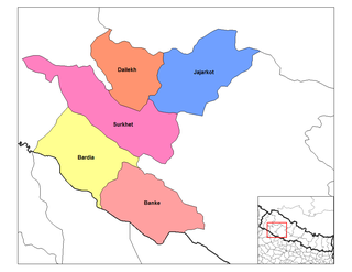
Dailekh District a part of Karnali province, is one of the seventy-seven districts of Nepal. The district, with Dailekh as its district headquarters, covers an area of 1,502 km² and had a population of 225,201 in 2001 and 261,770 in 2011.
Jaljala is a Village Development Committee in Baglung District in the Dhaulagiri Zone of central Nepal. At the time of the 1991 Nepal census it had a population of 3,637 and had 624 houses in the town.
Lapsiphedi is a village and former Village Development Committee that is now part of Shankharapur Municipality in Kathmandu District in Province No. 3 of central Nepal. At the time of the 1991 Nepal census it had a population of 5040 and had 919 households in it.
Gauri is a Village Development Committee in Dailekh District in the Bheri Zone of western-central Nepal. At the time of the 1991 Nepal census it had a population of 2008 people residing in 390 individual households.
Awalaching is a village development committee in Surkhet District in the Bheri Zone of mid-western Nepal. At the time of the 1991 Nepal census it had a population of 1911 people living in 286 individual households.

Betan is a village development committee in Surkhet District in the Bheri Zone of mid-western Nepal. At the time of the 1991 Nepal census it had a population of 2644 people living in 407 individual households.
Ghoreta is a village development committee in Surkhet District in the Bheri Zone of mid-western Nepal. At the time of the 1991 Nepal census it had a population of 1936 people living in 308 individual households.
Khanikhola is a village development committee in Surkhet District in the Bheri Zone of mid-western Nepal. At the time of the 1991 Nepal census it had a population of 3127 people living in 512 individual households.
Lagam is a village development committee in Surkhet District in the Bheri Zone of midwestern Nepal. At the 1991 Nepal census, it had a population of 3839 people in 647 households.
Lekhpharsa (लेखफर्सा) is a village development committee in Surkhet District in the Bheri Zone of mid-western Nepal. At the time of the 1991 Nepal census it had a population of 4809 people living in 805 individual households.
Lekhgaun, Bheri is a village development committee in Surkhet District in the Bheri Zone of mid-western Nepal. At the time of the 1991 Nepal census it had a population of 3999 people living in 651 individual households.
Mehelkuna is a village development committee in Surkhet District in the Bheri Zone of mid-western Nepal. At the time of the 1991 Nepal census it had a population of 7649 people living in 1404 individual households. Pavitra Bazzar is the largest town in this VDC. There are two Higher Secondary Schools.
Pamka is a village development committee in Surkhet District in the Bheri Zone of mid-western Nepal. At the time of the 1991 Nepal census it had a population of 1981 people living in 287 individual households.
Rajeni is a village development committee in Surkhet District in the Bheri Zone of mid-western Nepal. At the time of the 1991 Nepal census it had a population of 2730 people living in 430 individual households.
Ramghat is a Village Development Committee in Surkhet District in the Bheri Zone of mid-western Nepal. At the time of the 1991 Nepal census it had a population of 5581 people residing in 1060 individual households.
Sahare is a Village Development Committee in Surkhet District in the Bheri Zone of mid-western Nepal. At the time of the 1991 Nepal census it had a population of 7297 people residing in 1318 individual households.
Kalyan is a village development committee in Surkhet District in the Bheri Zone of mid-western Nepal. At the time of the 1991 Nepal census it had a population of 6426 people living in 1092 individual households.
Tatopani is a village development committee in Surkhet District in the Bheri Zone of mid-western Nepal. At the time of the 1991 Nepal census it had a population of 3973 people living in 759 individual households.
Sankarpur is a village development committee in Kanchanpur District in the Mahakali Zone of south-western Nepal. At the time of the 1991 Nepal census it had a population of 6538.