Ghazaouet

Last updated
Ghazaouet
الغزوات
Commune and town
Ghazaouet - 20240425 065403.jpg
DZ-13-07 - Ghazaouet - Wilaya Tlemcen.svg
Algeria location map.svg
Red pog.svg
Ghazaouet
Coordinates: 35°5′38″N1°51′37″W / 35.09389°N 1.86028°W / 35.09389; -1.86028
CountryFlag of Algeria.svg  Algeria
Province Tlemcen Province
Population
 (2008)
  Total33,774
Time zone UTC+1 (CET)
Ghazaouet Lighthouse
OOjs UI icon edit-ltr-progressive.svg
Les Deux-Freres.jpg
Coordinates 35°05′52.45″N1°52′23.69″W / 35.0979028°N 1.8732472°W / 35.0979028; -1.8732472
Constructed1868 [1]
Constructionmasonry tower
Height14.5 metres (48 ft) [1]
Shapecylindrical tower with balcony and lantern atop the centre of 1-storey keeper’s house [2]
Markingswhite tower, dark green lantern
OperatorOffice Nationale de Signalisation Maritime
Focal height95.4 metres (313 ft) [1]
Light sourcemain power
Range22 nautical miles (41 km; 25 mi) [1]
Characteristic Fl (3) W 15s. [3]

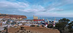
Ghazaouet is a town and commune in Tlemcen Province in northwestern Algeria. According to the 2008 census it has a population of 33 774. [4] It is renowned for its daily fresh seafood which include: Sardines, mackerels, and red snappers. Ghazaouet boasts with mountainous hills and close ports and beaches where locals can be seen diving and swimming near fishing boats. The port of Ghazaouet is also a point of entry for Algerians entering the country via boat from Almeria, Spain. The well known Algerian comedian Abdelkader Secteur is also from this town. The Lighthouse of Nemours, as displayed is also known by the locals as "Deux Frères". The rock itself is climbable however, requires a 7-to-10 minute swim from the pier/port to reach whereas, a ladder attached to the rock will allow you to climb onto a staircase to then walk around the top of the lighthouse, in which often times locals dive and jump from 95 meters high. This activity can be recognized just by standing at the pier/port. Ghazaouet was formerly and officially known as Nemours during the times Algeria was still recognised as a French colony.

Majority of Fliti's are also from this region.[ citation needed ]

See also

Related Research Articles

<span class="mw-page-title-main">Dellys</span> City in Algeria

Dellys is a small Mediterranean town in northern Algeria's coastal Boumerdès Province, almost due north of Tizi-Ouzou and just east of the Sebaou River. It is the district seat of the daïra of Dellys. The town is 45 km from Tizi Ouzou, 50 km from Boumerdes, and about 100 km from the capital Algiers.

<span class="mw-page-title-main">Saint Peter Port Harbour</span> Port Harbour located in Guernsey

Saint Peter Port Harbour is located in Saint Peter Port, Guernsey. It was a natural anchorage used by the Romans which has been changed into an artificial harbour that is now the island's main port for passengers. Loose cargo, liquids and gas are shipped to and from St Sampson's harbour.

<span class="mw-page-title-main">Tablas Island</span>

Tablas is the largest of the islands that comprise the province of Romblon in the Philippines. The name of the island was of Spanish origin. Before the colonization of the Philippines, Tablas was known as the Island of Osigan. At the time of contact with Westerners, Osigan had a population of two hundred and fifty people living in small villages. Wax was produced in this island.

<span class="mw-page-title-main">Jijel</span> City in Jijel Province, Algeria

Jijel, the classical Igilgili, is the capital of Jijel Province in north-eastern Algeria. It is flanked by the Mediterranean Sea in the region of Corniche Jijelienne and had a population of 131,513 in 2008.

<span class="mw-page-title-main">Saint-Marc</span> Commune in Artibonite, Haiti

Saint-Marc is a commune in western Haiti in Artibonite departement. Its geographic coordinates are 19°7′N72°42′W. At the 2003 Census the commune had 160,181 inhabitants. It is one of the biggest cities, second to Gonaïves, between Port-au-Prince and Cap-Haïtien.

<span class="mw-page-title-main">Sidi Fredj</span> Coastal town in Algiers Province, Algeria

Sidi Fredj, known under French rule as Sidi Ferruch, is a coastal town in Algiers Province, Algeria. It is located within the territory of the municipality of Staouéli, on a presque-isle on the Mediterranean Sea. It is the site of the ancient city and bishopric Obori, which remains a Catholic titular see.

<span class="mw-page-title-main">Ténès</span> Place in Chlef Province, Algeria

Ténès is a town in Algeria located around 200 kilometers west of the capital Algiers. As of 2000, it has a population of 65,000 people.

<span class="mw-page-title-main">Tralee Bay</span> Bay in County Kerry, Ireland

Tralee Bay is located in on the west coast of County Kerry, Ireland. It is situated between Kerry Head on the north side and the Maharees on the west and extends eastwards as far as the bridge at Blennerville. Several small rivers feed into the bay through the town of Tralee. Villages around the bay include; Ballyheigue, Fenit, Kilfinora, Spa, Blennerville, Camp and Castlegregory.

<span class="mw-page-title-main">Whiteford Lighthouse</span> Former lighthouse in Gower, Wales

Whiteford Point Lighthouse is located off the coast at Whiteford Point near Whiteford Sands, on the Gower Peninsula, South Wales.

<span class="mw-page-title-main">Grotto Point Light</span> Lighthouse in New South Wales, Australia

Grotto Point Light, also known as Port Jackson Entrance Range Front Light, is an active lighthouse located at Grotto Point, a rocky headland at the southernmost tip of Balgowlah Heights, New South Wales, Australia, on the north side of Sydney Harbour. It serves as the front range light, Rosherville Light serving as the rear light, into Port Jackson. Rosherville Light is located almost exactly 1 mile (1.6 km) behind Grotto Point Light.

<span class="mw-page-title-main">Donaghadee Lighthouse</span> Lighthouse in Northern Ireland

Donaghadee Lighthouse is a lighthouse in Donaghadee County Down, Northern Ireland. Donaghadee is probably best known for its lighthouse and harbour. There has been a haven for ships at Donaghadee for centuries, and there has also existed a harbour since at least the 17th century.

<span class="mw-page-title-main">Poolbeg Lighthouse</span> Lighthouse in Dublin, Ireland

Poolbeg Lighthouse is an active aid to navigation at the mouth of the River Liffey, near Poolbeg in Dublin, Ireland. First established in 1767, it initially operated on candlepower but this was changed to oil in 1786. It was re-designed and re-built into its present form in 1820.

<span class="mw-page-title-main">Beach Lighthouse, Fleetwood</span> Sandstone lighthouse in Fleetwood, Lancashire, England

The Beach Lighthouse is a 44-foot (13 m) tall sandstone lighthouse in Fleetwood, Lancashire, England.

<span class="mw-page-title-main">Eilat Light</span> Lighthouse

Eilat Light is a lighthouse in Eilat, Israel. It is located on a bluff on the west side of the Gulf of Aqaba, about 1.2 kilometres (0.75 mi) northeast of the Egyptian border and 7 kilometres (4.3 mi) southwest of the port of Eilat. The location is locally known as "the lighthouse beach", and is used for camping and snorkeling. It is close to the "University" diving location.

<span class="mw-page-title-main">Stanislav Range Front Light</span> Lighthouse in Ukraine

Stanislav Range Front Light or Small Adzhyhol Lighthouse is an active lighthouse and range light, located on a concrete pier on a tiny islet about 7 kilometres (4.3 mi) west northwest of Rybalce, about 35 kilometres (22 mi) from Kherson, Ukraine. Together with Adziogol lighthouse, located 6.49 kilometres (4.03 mi) 109° from it, it serves guiding ships entering the Dnieper River.

<span class="mw-page-title-main">Azeffoun</span> Commune and town in Tizi Ouzou Province, Algeria

Azeffoun, the classical Rusazus and colonial Port Gueydon, is a town and commune in Tizi Ouzou Province in northern Algeria, located on Cape Corbelin 64 km (40 mi) north-east of Tizi Ouzou. The economy of the town of Azeffoun is based on tourism, fishing, and agriculture.

<span class="mw-page-title-main">Habibas Islands</span> Lighthouse

The Habibas islands35°43′29″N1°8′00″W are located about 12 km off the Algerian coast, northwest of Oran. The islands consist of a principal island 1.3 km long surrounded by an archipelago covering a total area of about 40 ha. The highest point on the Habibas islands reaches 105 m. The islands are of volcanic origin.

<span class="mw-page-title-main">Detached Mole, Gibraltar Harbour</span>

The Detached Mole is a breakwater located at the western aspect of the middle section of Gibraltar Harbour, in the British Overseas Territory of Gibraltar, at the southern end of the Iberian Peninsula. The Detached Mole, with the rest of harbour, is just north of the east entrance to the Strait of Gibraltar and was the site of the Detached Mole Battery. In addition to the role the breakwater plays in the defence of and access to the harbour, the Detached Mole provides berths for ships. The area adjacent to the mole is also a source of recreational and research opportunities, with dive sites at the wrecks of sunken ships.

<span class="mw-page-title-main">Daedalus Reef</span> Reef in the Egyptian Red Sea

Daedalus Reef is a 400-meter-long and 100-meter-wide (1,310–330 ft) standalone reef in the Egyptian Red Sea situated about 90 kilometers from Marsa Alam. There is a small artificial island in the center of the reef, which hosts a lighthouse constructed in 1863 and rebuilt in 1931. Daedalus reef is a well-known place for diving because of good chances to see pelagic fish, such as hammerhead sharks, and an abundance of corals. In the high season one can find many dive safari boats staying overnight, anchored to the reef.

<span class="mw-page-title-main">Puerto Morelos Lighthouse</span> Lighthouse

Puerto Morelos Lighthouse is an active lighthouse in the town and port of Puerto Morelos, on the Riviera Maya in the state of Quintana Roo, Mexico. The current lighthouse is the third in a succession of lights that have operated at the site on the seafront, close to the main pier. The second lighthouse, known as the Inclined Lighthouse, began tilting in 1967 and remains in place.

References

  1. 1 2 3 4 "Ghazaouet". Office Nationale de Signalisation Maritime. Ministere des Travaux Publics. Retrieved 29 April 2017.
  2. Rowlett, Russ. "Lighthouses of Western Algeria". The Lighthouse Directory. University of North Carolina at Chapel Hill . Retrieved 29 April 2017.
  3. List of Lights, Pub. 113: The West Coasts of Europe and Africa, the Mediterranean Sea, Black Sea and Azovskoye More (Sea of Azov) (PDF). List of Lights . United States National Geospatial-Intelligence Agency. 2015.
  4. "Communes of Algeria". Statoids. Retrieved December 12, 2010.

35°06′N1°51′W / 35.100°N 1.850°W / 35.100; -1.850