The Institute of the Blessed Virgin Mary, whose members are commonly known as the Loreto Sisters, is a Roman Catholic religious congregation of women dedicated to education founded in Saint-Omer by an Englishwoman, Mary Ward, in 1609. The congregation takes its name from the Marian shrine at Loreto in Italy where Ward used to pray. Ward was declared Venerable by Pope Benedict XVI on 19 December 2009. The Loreto Sisters use the initials I.B.V.M. after their names.
The Metropolitan Borough of Dudley is a metropolitan borough of West Midlands in England. It was created in 1974 following the Local Government Act 1972, through a merger of the existing Dudley County Borough with the municipal boroughs of Stourbridge and Halesowen. The borough borders Sandwell to the east, the city of Birmingham to the south east, Bromsgrove to the south in Worcestershire, South Staffordshire District to the west, and the city of Wolverhampton to the north.

Mary Ward Catholic Secondary School is a Catholic secondary school in Scarborough, a district of Toronto, Ontario, Canada part of the Toronto Catholic District School Board, formerly the Metropolitan Separate School Board. Mary Ward is a centre of self-directed learning and a member of the Canadian Coalition of Self-Directed Learning. It is one of only two self-directed learning schools currently in Ontario and seven in Canada.

Rukum District was a "hill" and "mountain" district some 280 km (170 mi) west of Kathmandu partially belonging to Province No. 5 and partially to Karnali Pradesh before split into two districts Western Rukum and Eastern Rukum after the state's reconstruction of administrative divisions in 2017. Rukum covers an area of 2,877 km2 (1,111 sq mi) with population of 207,290 in 2011 Nepal census. Musikot was the district's administrative center.

Nepalgunj, also spelled Nepalganj, is a Sub-Metropolitan City in Banke District, Nepal. It lies on the Terai plains near the southern border with Bahraich district in Uttar Pradesh, India. Nepalgunj is 153 kilometers south-west of Ghorahi and 16 km south of Kohalpur. Former Village Development Committee: Udayapur, Bhawaniyapur, Piprahawa, Jaispur, Paraspur, Indrapur, Khaskarkado, Bashudevpur, Manikapur and Puraina were added to territory in order to make it Sub metropolitan city on 2071 Paush 28 and later Puraini was also added in list on 2072 Paush 21. Further, while restructuring of local levels nationwide, ward no. 23 was taken out to Janaki Rural Municipality and ward no. 7 of Hirminiya VDC was added to Nepalgunj.

Kiambu County is a county in the former Central Province of Kenya. Its capital is Kiambu and its largest town is Thika. Kiambu County borders Nairobi and Kajiado Counties to the South, Machakos to the East, Murang‘a to the North and North East, Nyandarua to the North West, and Nakuru to the West and has a population of 2,417,735.

Kodungaiyur is a residential neighbourhood in the northern part of the city of Chennai, Tamil Nadu, India. It comes under Perambur Taluk of the Chennai District.
Siraha is the headquarters and municipality of Siraha District, a part of Province No. 2, Nepal. Siraha had a population of 28,442 according to the census of 2011. and a population of 82,531 as of 2015. The mayor ois Asheswor Yadava and the deputy mayor is Dr. Namita Yadav. Both assumed office on 25 September 2017. The town is at 80 metres (260 ft) altitude, 29 kilometres (18 mi) ESE of Janakpur.
Tulsipur is a Sub-Metropolitan City in Dang District of Lumbini Province of Nepal. As per population, it is the district's second most populous city after Ghorahi. It was established in 1992 by merging the former Village development committees Tulsipur and Amritpur. In 2014, it was expanded and the Village development committees of Urahari, Tarigaun, Pawannagar and Halwar. At the time of the 2011 Nepal census it had a population of 141,528 people living in 31,243 individual households.
Aathbiskot is a Municipality in West Rukum District in Karnali province of Nepal that was established in 2015 through the merging the former Village development committees of Aathbiskot, Aathbisdandagaun, Ghetma, Magma, Gotamkot and Syalakhadi. At the time of the 2011 Nepal census it had a population of 33,601 people living in 6,421 individual households.

Musikot is a municipality and the district headquarter of Western Rukum District in Karnali province of Nepal that was established as Musikot Khalanga on 18 May 2014 by merging the two former Village development committees Musikot and Khalanga. It lies on the bank of Sani Bheri River. It borders with Eastern Rukum in the east, Sanibheri rural municipality in the west, Banfikot rural municipality in the north and Tribeni rural municipality and Rolpa district in the south. Musikot was formerly called Musikot Khalanga and served as the district headquarter of Rukum District.
Takasera is a village development committee in Eastern Rukum District in Province No. 5 of western Nepal. At the time of the 2011 Nepal census it had a population of 3698 people living in 902 individual households. It has altogether 6 clustered villages in different locations within the Takasera VDC and the clustered village names are Taka, Upallo (upper) Sera, Lower (down) Sera, BachiGaun, Ghumlibang,Damchan and Tupa. As per the new federal government system, Takasera has been in the Putha Utterganga Rural Municipality (Ga.Pa.) wards being 10 and 11, in the Rukum Purba (East) district.
Prayas Nepal is a non-profit, non-governmental organization in Nepal. It is registered with the District Administrative Office of Kathmandu. Prayas Nepal aims to protect the rights of children and the underprivileged including orphans, women and elderly in Nepal by helping them to access essential services such as education and health care.

Lumbini Province is one of the seven provinces established by the new constitution of Nepal which was adopted on 20 September 2015. The province covers an area of 22,288 km2 - about 15.1% of the country's total area. The Provincial Assembly adopted Lumbini Province as the permanent name by replacing its initial name Province No. 5 on 6 October 2020 and Rapti Valley, Dang, Nepal was declared the state capital of the province. It borders Gandaki Province and Karnali Province to the north, Sudurpashchim Province to the west, and Uttar Pradesh of India to the south. The major cities in this province are Butwal, and Bhairahawa from Rupandehi district, Nepalgunj from Banke district, Tansen from Palpa District while Ghorahi and Tulsipur from Dang District, Nepal.

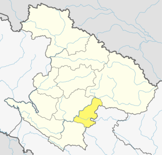
Eastern Rukum is a mountain district located in the Lumbini Province of Nepal. It is one of the twelve districts of the province and contains over sixty percent of Dhorpatan Hunting Reserve in the western section of Dhaulagiri mountain range. It is also the only mountain-district of the province with its tallest mountain Putha Hiunchuli situated in the west end of Dhaulagiri II mountain chain, at an elevation of 7,246 meters. Eastern Rukum has been included as one of "Nepal´s top 100 travel destinations" by the Government of Nepal.
Western Rukum a part of Karnali province, is one of the seventy-seven districts of Nepal. Musikot is the headquarter of the district.
Khadak Municipality is located in Saptari District in the Province 2 of Nepal. It was formed in 2016 occupying current 11 sections (wards) merging previous Siswa Belhi, Banarjhula, Pansera, Khojpur, Kalyanpur, Fulbariya, Mainasarsabahu and Banauli VDCs, residing its head office at Kalyanpur Bazaar. It occupies an area of 96.77 km2 with a total population of 45,367.
Agnisaira Krishnasavaran is a rural municipality in Saptari District in the Sagarmatha Zone of south-eastern Nepal. At the time of the 2017 Nepal census it had a population of 27,129 people living in 2265 individual households.
Pacharauta is a municipality in Bara District in Province No. 2 of South-Eastern Nepal. It was formed in 2016 occupying current 9 sections (wards) from previous 9 former VDCs. It occupies an area of 44.01 km2 with a total population of 34,175.
