Ghorakhal

Last updated

Ghorakhal
town

Golu Ghorakhal.JPG

Golu Devta temple, Ghorakhal
India Uttarakhand location map.svg
Red pog.svg
Ghorakhal
Location in Uttarakhand, India
India location map.svg
Red pog.svg
Ghorakhal
Ghorakhal (India)
Coordinates: 29°24′0″N79°28′7″E / 29.40000°N 79.46861°E / 29.40000; 79.46861 Coordinates: 29°24′0″N79°28′7″E / 29.40000°N 79.46861°E / 29.40000; 79.46861
CountryFlag of India.svg  India
State Uttarakhand
District Nainital
Languages
  Official Hindi
Time zone IST (UTC+5:30)
Vehicle registration UK
Website uk.gov.in

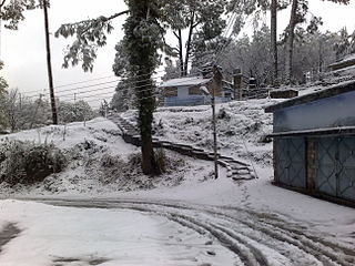
Ghorakal is the place situated in the Nainital district of the Uttarakhand state of India. Ghorakhal means pond for water to horses. It is the picturesque site at the height of more than 2,000 m.

Nainital district District in Uttarakhand, India

Nainital district is a district of Uttarakhand state, India. The headquarters is at Nainital.

Uttarakhand State in Northern India

Uttarakhand, formerly known as Uttaranchal, is a state in the northern part of India. It is often referred to as the Devabhumi due to a large number of Hindu temples and pilgrimage centres found throughout the state. Uttarakhand is known for the natural environment of the Himalayas, the Bhabhar and the Terai. On 9 November 2000, Uttarakhand became the 27th state of the Republic of India, being created from the Himalayan districts of Uttar Pradesh. It borders Tibet Autonomous Region of China to the north; the Sudurpashchim Pradesh of Nepal to the east; the Indian states of Uttar Pradesh to the south and Himachal Pradesh to the west and north-west. The state is divided into two divisions, Garhwal and Kumaon, with a total of 13 districts. The interim capital of Uttarakhand is Dehradun, the largest city of the state, which is a railhead. The High Court of the state is located in Nainital.

India Country in South Asia

India, also known as the Republic of India, is a country in South Asia. It is the seventh largest country by area and with more than 1.3 billion people, it is the second most populous country as well as the most populous democracy in the world. Bounded by the Indian Ocean on the south, the Arabian Sea on the southwest, and the Bay of Bengal on the southeast, it shares land borders with Pakistan to the west; China, Nepal, and Bhutan to the northeast; and Bangladesh and Myanmar to the east. In the Indian Ocean, India is in the vicinity of Sri Lanka and the Maldives, while its Andaman and Nicobar Islands share a maritime border with Thailand and Indonesia.

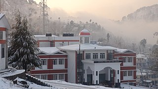
It is situated near Bhowali and is the seat for Army school, known as Sainik School Ghorakhal, established in 1966 at the Ghorakhal Estate of the Nawab of Rampur. The famous Golu Devta temple is situated on a hill above overlooking the school. [1]

Bhowali city in Uttarakhand, India

Bhowali is a town and a municipal board in Nainital District in the state of Uttarakhand, India. It lies close to Ghorakhal, known for Golu Devta temple and Sainik School Ghorakhal.

Some scenes of Madhumati 1958 classic by Bimal Roy, which was shot extensively around Nainital had some scenes shot at Ghorakhal as well. And scene of the temple in Vivah 2006 movie had the scene from the famous Golu Devta Mandir [2]

<i>Madhumati</i> 1958 film by Bimal Roy

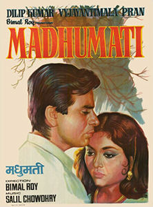
Madhumati is a 1958 Indian paranormal romance film directed and produced by Bimal Roy, and written by Ritwik Ghatak and Rajinder Singh Bedi. The film stars Dilip Kumar and Vyjayantimala in the lead roles, with Pran and Johnny Walker in supporting roles. The plot focuses on Anand, a modern man who falls in love with a tribal woman named Madhumati. They are unable to have a relationship during their lifetimes and are reincarnated.

Bimal Roy Indian film director

Bimal Roy was a Bengali Indian film director. He is particularly noted for his realistic and socialistic films such as Do Bigha Zamin, Parineeta, Biraj Bahu, Madhumati, Sujata, Parakh and Bandini, making him an important director of Hindi cinema. Inspired by Italian neo-realistic cinema, he made Do Bigha Zamin after watching Vittorio De Sica's Bicycle Thieves (1948). His work is particularly known for his mise en scène which he employed to portray realism. He won a number of awards throughout his career, including eleven Filmfare Awards, two National Film Awards, and the International Prize of the Cannes Film Festival. Madhumati won 9 Filmfare Awards in 1958, a record held for 37 years.

<i>Vivah</i> 2006 film by Sooraj R. Barjatya

Vivah is a 2006 Indian romantic drama film, written and directed by Sooraj R. Barjatya. Starring Amrita Rao and Shahid Kapoor, it was produced and distributed by Rajshri Productions. Vivah tells the story of two individuals, and relates their journey from engagement to marriage and aftermath.

Related Research Articles

Kumaon division administrative division of Uttarakhand, India

For Kumaoni people see Kumaoni people

Almora district District in Uttarakhand, India

Almora district is a district in the Kumaon division of Uttarakhand state, India. The headquarters is at Almora. It is 1,638 meters above sea level. The town of Almora is surrounded by Pithoragarh district to the east, Garhwal region to the west, Bageshwar district to the north and Nainital district to the south.

Narsinghgarh, Damoh town in Madhya Pradesh, India

Narsinghgarh is a town of historical importance in the Damoh District of Madhya Pradesh in India. There is an ancient fort built by Gondwana Kings in Narsinghgarh. The town Narsinghgarh is situated on Sonar River. Birla group has established one cement factory at Narsinghgarh. Now Heidelberg cement company of Germany has overtaken it, and now produces cement by the name of Mycem Cement.There are many more historic places in Narsingarh such as The Jankiraman temple dedicated to lord ram and mata sita, in one side of the temple there is some part of the fort of Narsingarh a few meter distance there is an old temple of Siddha Ganesha Mandir the local people called any thing you want lord Ganesh will provide it to you. The main part of the ancient fort which is built by The Godwana King is situated beside the Lord ganesha temple. Ram Bagh Temple in this temple Lord Hanuman is worshiped. There are many stories about this temple but the most popular belief is that the statue of Lord Hanuman was taken out from the well situated near the temple, by a cowboy after the instruction given by Lord Hanuman in his dream. On every Makarsankranti the fair (mela) organised by the near by locals, Another place which the locals call as Tullu Jhiriya is famous for continuous flowing water from the rocks.

Ranikhet Town in Uttarakhand, India

Ranikhet is a hill station and cantonment town in Almora district in the Indian state of Uttarakhand. It is the home for the Military Hospital, Kumaon Regiment (KRC) and Naga Regiment and is maintained by the Indian Army. Ranikhet is at an altitude of 1,869 metres (6,132 ft) above sea level and within sight of the western peaks of the Himalayas.

Sattal or Sat Tal is an interconnected group of seven freshwater lakes situated in the Lower Himalayan Range near Bhimtal, a town of the Nainital district in Uttarakhand, India. During the British Raj, the area had a tea plantation, one of four in the Kumaon area at that time.

Chand kings

The Chand Kings were a medieval Rajput ruling clan of the Kumaon region of the Uttarakhand state of India, which ruled the region after the decline of Katyuri Kings in 11th century AD. It claimed Raghuvanshi ancestry.

Rudraprayag district District in Uttarakhand, India

Rudraprayag district, is a district of Uttarakhand state of northern India. The district occupies an area of 2439 km². Rudraprayag town is the administrative headquarters of the district. The district is bounded by Uttarkashi District on the north, Chamoli District on the east, Pauri Garhwal District on the south, and Tehri Garhwal District on the south.

Sainik School, Ghorakhal

Sainik School, Ghorakhal is a Sainik School established by the Sainik Schools Society in 1966. It is located in Ghorakhal, 4 kilometres next to the Bhowali town, at an altitude of about 6,000 feet (1,800 m) above sea level amidst the Kumaon Hills in Nainital district of the state of Uttarakhand, India.

Berinag hill station in Uttarakhand, India

Berinag, is a hill station, located 160 km from Nainital in the Pithoragarh district, which is the easternmost Himalayan district in the state of Uttarakhand, India. It is one of the six Administrative Subdivisions (tehsil) of Pithoragarh. National Highway 309A passes through Berinag. Closest prominent villages include Garawon, Dhanoli, Bana, Bhattigaon, Banoli, Quarali, Tripuradevi and Sangarh.

Ramnagar, Uttarakhand city in Uttarakhand, India

Ramnagar is a small town and municipal board in the Nainital district of Uttarakhand, India. It is located approximately 65 kilometres (40 mi) from Nainital, the headquarters of the district.

Bhimtal Town in Uttarakhand, India

Bhimtal is a town and a nagar panchayat in Nainital district in the state of Uttarakhand, India, situated at an altitude of 1370 meters above sea level and is about 22 kilometers from Nainital. The major attraction in Bhimtal is the Bhimtal Lake, which has an island at its centre. Besides tourism, Bhimtal has also now become a mini district headquarters since most of the district administration offices have been shifted to the newly constructed Vikas Bhawan, the building complex for district administrative offices.

Golu Devata

Golu Devta or Lord Golu is the legendary God of the Kumaun and eastern Garhwal region of Uttarakhand state of India and is their deity. In eastern Garhwal, he is worshipped as Goril Devta.

Nathuakhan village in Uttarakhand, India

Nathuakhan is a village in the Ramgarh block of the Nainital district in the state of Uttarakhand. It is situated at a height of 1940 meters, in the heart of Kumaon Mountains of the central Himalayas, close to the towns of Mukteshwar and Nainital. Also close by are places like Hartola and Ramgarh, all accessible from Nainital and Bhimtal.

Dhaulakot Village chandakot development committee in Mahakali Zone, Nepal

Dhaulakot is a village development committee in Darchula District in the Mahakali Zone of western Nepal. At the time of the 1991 Nepal census it had a population of 2094 people living in 337 individual households.

Binoli village in Uttarakhand, India

Binoli is a small town in the Almora district in the state of Uttarakhand, India.

Mahasu Devta Temple building in India

Mahasu Devta Temple ,(Garhwali: महासू देवता मंदिर,हनोल) is located on the Tuini-Mori road at Hanol. The temple is dedicated to Mahasu Devta. Lord Mahasu is the chief deity of this area and is worshiped in Mahasu Devta Temple by the people of Hanol and nearby villages. It is the ancient temple of Mahasu Devta built in the 9th century. The temple was constructed in Kath-Kuni or Koti-Banal style of architecture. It is included in the Archaeological Survey of India list of ancient temple in Dehradun circle, Uttarakhand.

Naukuchiatal lake in India

Naukuchiatal or "lake of nine corners" is a small hill station in Nainital district of the Indian state of Uttarakhand. The lake is 175 feet deep and is situated at 1,220 m above sea level. It is surrounded by hills covered in trees and shrubs. It is the deepest of all the lakes in the Nainital region. The length of the lake is 983 m, its breadth is 693 m and it has a depth of 40.3 m. Within the valley are opportunities for angling and bird watching. Other activities include parasailing, paragliding, fishing, rowing, paddling or yachting. The lake is fed by an underground perennial spring. Naukuchiatal is also known for the 'escape festival' which happens once every year.

Kumaon Kingdom

Kumaon Kingdom was a Himalayan kingdom ruled by Many Himalayan dynasties in the Kumaon region of present-day Uttarakhand state of India

References

  1. Ghorakhal Official website of Nainital district.
  2. "Hero worship". Mint . 4 January 2013. Retrieved 2014-09-07.