Aarhus is the second-largest city in Denmark and the seat of Aarhus municipality. It is located on the eastern shore of Jutland in the Kattegat sea and approximately 187 kilometres (116 mi) northwest of Copenhagen.

Malling is a village in Denmark, located about 12 km (7.5 mi) south of Aarhus. It has a population of 6,194 (Jan 1, 2020).

Moesgaard Museum (MOMU) is a Danish regional museum dedicated to archaeology and ethnography. It is located in Beder, a suburb of Aarhus, Denmark.

Højbjerg is a postal district of Aarhus, Denmark.

Skåde is a neighbourhood of Højbjerg, a southern district of Aarhus in Denmark. It is located 6 km south from the city centre.

Grenaa is a Danish town and seaport on the east coast of the Jutlandic peninsula. Tourism, education and commerce are important sectors in the economy of Grenaa. It is the only larger town on Djursland. Grenaa is the municipal seat, and the largest town, in Norddjurs Municipality, which covers the northern half of Djursland.

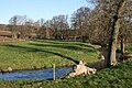
Aarhus River is a 40-kilometre (25 mi) long river or stream, in eastern Jutland, Denmark.

Egå Engsø is an artificial lake and wetland site located in the north of the town of Aarhus between Vejlby, Risskov and Lystrup. Engsø means 'meadow lake' and Egå means 'oak stream', referring to the stream that drains the lake into the Aarhus bay. The lake area is bordered by the Djursland motorway to the north and the Aarhus-Grenaa railway and the municipal heating pipes from Studstrup Power Station to the south and west.

Brabrand Lake is a lake in the district of Brabrand (Gellerup), west of Aarhus city, Denmark. The Aarhus River passes through Brabrand Lake and it is possible to canoe all the way to the inner city from here. The lake is oblong-shaped.

Marselisborg Forests, or simply Marselisborg Forest, is a 550 hectares forest to the south of Aarhus City in the Kingdom of Denmark. Many present day sources now includes the forest of Fløjstrup, as part of the Marselisborg Forests, upping the total area with another 200 hectares. Marselisborg Forests runs along the coastline of the Aarhus Bay in a hilly terrain with steep slopes and deep gullies, especially at the shoreline. There are many traces of prehistoric activities here and the landscape have been covered by woodlands for thousands of years.
The following is a timeline of the history of the city of Aarhus, Central Denmark Region, Denmark.
Vilhelmsborg is the National Equestrian Centre of Denmark and a listed building in Aarhus Municipality. The main manor building was completed in 1842 and was listed by the Danish Heritage Agency on 3 March 1945. The manor lies 10 km. south of Aarhus, by Beder-Malling in Mårslet Parish, and is today owned by Aarhus Municipality along with 288 hectares of adjoining land.

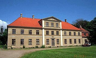
Moesgård is a former manor house and a listed building in Aarhus Municipality. The current buildings were completed in 1778 and was listed in the Danish registry of protected buildings and places by the Danish Heritage Agency on 17 July 1918.

Moesgård Forest Mill is a mill and a listed building in Aarhus, Denmark. The mill was built in 1785 and was listed on the Danish registry of protected buildings and places by the Danish Heritage Agency on 13 April 1984. The mill is situated in the Marselisborg Forests just south of the suburb Skåde and Moesgård Museum, some 6 km. south of Aarhus city center.

Bispetorv is a public square located in the Indre By neighborhood in Aarhus, Denmark.

Skæring Hede or Skæring Mindelund is a forest and memorial park in Skæring, the northernmost suburb of Aarhus, Denmark. Skæring Hede was originally a large heath but today only a fraction of it remains as encroaching suburbs and areas with summer houses have gradually taken over much of the natural land in the area, through the 70s and 80s. The remaining area of 8.5 hectares are mainly forest, although some heath do remain, and is managed as a public forest park by Aarhus Municipality. Today Skæring Hede is one of only a few public forests in Skæring and the northernmost park in Aarhus. The forest is mainly mixed pine and birch forest with a number of walking paths crossing through it and it is home to a World War II memorial. Skæring Hede is well known as the place where five Danish resistance fighters were executed during the Second World War in one of the first mass executions during the war. Parking facilities on Åstrup Strandvej.
Lillering Forest is a forest and protected Natura 2000 area in Denmark. It is located in peninsular Denmark in Aarhus Municipality, south of Harlev and some 10 km. west of Aarhus. It is a deciduous forest covering some 50 hectares and it is composed mainly of beech and European ash. It is privately owned but protected and partially managed by Aarhus Municipality and the Danish Nature Agency. The Natura 2000 site covers 135 hectares and also encompasses Tåstrup Bog, Tåstrup Lake and Stjær Forest, south of Lillering Forest. The southern section with Stjær Forest is within, and managed by, Skanderborg Municipality.

Moesgård Beach is a public Blue Flag beach in Aarhus Municipality in Denmark. The beach is located in the southern outskirts of Aarhus in the Marselisborg Forests on the Bay of Aarhus in the suburb of Højbjerg. Helgenæs lies across the bay to the east, a bit inland to the west is the Marselisborg Deer Park and to the north is the Varna Palace. The beach area is some 1000 meters long and between 25 and 40 meters wide. It is a white sandy beach with occasional rows of boulders extending into the sea, for coastal erosion protection. Moesgård Beach is popular for sunbathing and swimming due to the shielding effects and scenic views of the nearby forests on the steep hillsides to the west. The beach has a single jetty extending some 20 meters into the sea, offering a platform to jump from or relax on. The Beach is open year-round for everyone at no charge.

Idrætsforeningen Lyseng Fodbold, commonly known as IF Lyseng, is an association football club based in the suburb of Højbjerg, Aarhus Municipality, Denmark, that competes in the Denmark Series, the fourth tier of the Danish football league system. The club's name comes from its home ground, which is located on the former land of Lysenggård, a farm in Højbjerg. The football department is the most notable one of Idrætsforeningen Lyseng, a major multi-sport club who compete in football, handball, volleyball, swimming and beach volleyball, among others.