Sandnes (help·info) is a city and municipality in Rogaland county, Norway. It is the 8th largest city in Norway and it lies immediately south of the city of Stavanger, the 4th largest city in Norway. Together, the Stavanger/Sandnes area is the 3rd largest urban area in Norway.

Time is a municipality in Rogaland county, Norway. It is located in the traditional district of Jæren. The administrative centre of the municipality is the town of Bryne. Some villages in the municipality include Kvernaland, Lyefjell, Mossige, and Undheim. Most of Time is fairly flat and it is used for agriculture. The eastern portion of the municipality is more rugged moorland.

Forsand is a municipality in Rogaland county, Norway. It is located in the traditional district of Ryfylke. The administrative centre of the municipality is the village of Forsand. Other villages in the municipality include Lysebotn, Øvre Espedal, Oanes, Kolabygda, and Fløyrli.

Kleppe is the administrative centre of Klepp municipality in Rogaland county, Norway. The village is located about halfway between the lakes Orrevatnet and Frøylandsvatnet. The village of Bore lies about 3 kilometres (1.9 mi) northwest of Kleppe and the village of Klepp stasjon lies about 3 kilometres (1.9 mi) to the east. The town of Bryne lies about 5 kilometres (3.1 mi) to the south and the city of Sandnes is located about 12 kilometres (7.5 mi) to the northeast. Klepp Church is located in Kleppe.

Tau is a village in Strand municipality in Rogaland county, Norway. The village is located on the shore of the Horgefjorden, a branch of the main Boknafjorden. The 2.11-square-kilometre (520-acre) village has a population (2015) of 3,158 which gives the village a population density of 1,497 inhabitants per square kilometre (3,880/sq mi). Strand Church is located in the village.

Månafossen is a waterfall in Gjesdal municipality in Rogaland county, Norway. The 92-metre (302 ft) tall waterfall is located along the river Månaåna, about 6 kilometres (3.7 mi) east of the end of the Frafjorden where the village of Frafjord is located. The waterfall is in a fairly isolated area. There is a parking area nearby with a steep, rough 250-metre (820 ft) hiking trail up a mountainside to see the waterfall. The hike takes about 30 minutes.

Ålgård is the administrative centre of Gjesdal municipality in Rogaland county, Norway. The village is located along the European route E39 highway, about 10 kilometres (6.2 mi) southeast of the city of Sandnes in the Jæren district of the county. The village includes the neighborhoods of Ålgård, Bærland, Fiskebekk, Opstad and Solås. The large lake Edlandsvatnet lies on the south side of the village, emptying into the river Figgjoelva which runs northwest to Sandnes.

Vikeså or Vigjeså is the administrative centre of Bjerkreim municipality in Rogaland county, Norway. The village is located along the European route E39 highway at a crossroads with the village of Ålgård about 20 kilometres (12 mi) to the northwest, the village of Dirdal about 25 kilometres (16 mi) to the northeast, and the town of Egersund about 20 kilometres (12 mi) to the south. The lake Svelavatnet lies along the south side of the village.
Pollestad is a village in Klepp municipality in Rogaland county, Norway. The village is located south of the lake Orrevatnet and about 5 kilometres (3.1 mi) southwest of the town of Bryne. Orre Church is located in Pollestad. It was built in 1950 to replace the nearly 800-year-old Ole Orre Church located 3 kilometres (1.9 mi) to the northwest in the village of Orre.

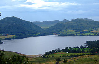
Oltedalsvatnet is a lake in the municipality of Gjesdal in Rogaland county, Norway. The 3.12-square-kilometre (1.20 sq mi) lake lies just south of the village of Oltedal. It is a reservoir along the river Oltedalsåna that is used to store water for the Oltedal Hydroelectric Power Station. The lake sits at an elevation of 101.5 to 112.5 metres and it holds about 28,800,000 cubic metres.

Dirdal is a village in Gjesdal municipality in Rogaland county, Norway. The village is located where the Frafjorden joins the main Høgsfjorden. The village lies at the end of the Dirdalen valley, which stretches to the southeast from Dirdal. The village of Gilja lies about 5 kilometres (3.1 mi) into the valley. The village of Oltedal lies about 8 kilometres (5.0 mi) west of Dirdal. Dirdal Church is located in the village.

Høle is a borough and village in the western part of Sandnes municipality in Rogaland county, Norway. It is located along the Høgsfjorden in the eastern part of the municipality. The area was historically a part of the municipality of Høle. Høle Church and Høle School are both located in the village. The Norwegian National Road 13 runs through the village and the borough.
Edlandsvatnet is a lake in the municipality of Gjesdal in Rogaland county, Norway. The 2.11-square-kilometre (0.81 sq mi) lake lies just south of the large village of Ålgård, immediately southwest of the lake Limavatnet. The European route E39 highway runs along the northern shore of the lake. The lake empties into the river Figgjoelva on the northwestern end of the lake. The lake has many brown trout in it.
Flassavatnet is a lake in Rogaland county, Norway. The lake lies on the border of the municipalities of Gjesdal and Sandnes. The 0.9243-square-kilometre (0.3569 sq mi) lake sits about 1 kilometre (0.62 mi) north of the large village of Ålgård, not far north of the lakes Edlandsvatnet and Limavatnet. The lake is a reservoir with a small dam on the southern edge of the lake. The water level is kept at about 177 metres (581 ft) above sea level. The reservoir holds about 900,000 cubic metres.
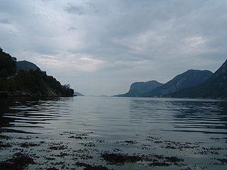
Høgsfjorden is a fjord in Rogaland county, Norway. The innermost part of the fjord is located at the village of Frafjord in the municipality of Gjesdal. It flows west to Dirdal and then heads northwards. At the village of Forsand, the Lysefjord branches off to the northeast. The Høgsfjorden continues to the northwest past the islands of Idsal and Idse before emptying into the Horgefjorden and ultimately into the vast Boknafjorden. The fjord runs through the municipalities of Gjesdal, Forsand, Sandnes, and Strand.

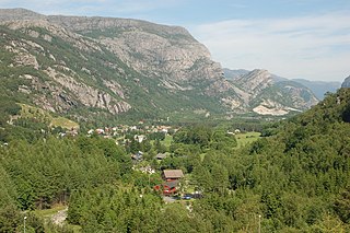
Frafjord is a village and farming community in the municipality of Gjesdal in Rogaland county, Norway. It is located in the Frafjorddalen valley, at the innermost end of the Frafjorden, a branch of the larger Høgsfjorden. The village had about 100 inhabitants in 2001. The 3.8-kilometre (2.4 mi) long Frafjord Tunnel connects the village of Frafjord to the villages of Gilja and Dirdal on the other side of the mountains, replacing the old, narrow, winding road over the mountain pass. The Månafossen waterfall lies about 5 kilometres (3.1 mi) northeast of the village of Frafjord.
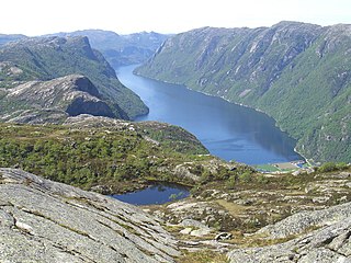
Frafjorden is a fjord in the municipalities Gjesdal and Forsand in Rogaland county, Norway. The 6-kilometre (3.7 mi) fjord is the innermost branch of the Høgsfjorden. The Frafjorden has steep sides with no habitation along its shores, except for the village of Frafjord at the innermost part of the fjord. The village and the surrounding Frafjorddalen farming valley stretches about 5 kilometres (3.1 mi) east of the fjord and the whole area has about 100 residents. There are also many holiday cottages on top of the high mountain located south of the village of Frafjord. The village of Dirdal is located at the mouth of the Frafjorden.

The Frafjord Tunnel is a road tunnel in Gjesdal municipality in Rogaland county, Norway. The 3,812-metre (12,507 ft) long tunnel is located along the Norwegian county road 281 connecting the villages of Frafjord and Gilja which are in two separate valleys with a large mountain between them. The tunnel opened on 10 June 1999 to replace the old, narrow, winding road that crosses the mountain pass above it, making the trip a faster and safer one.
Oltedal is a village in Gjesdal municipality in Rogaland county, Norway. The village is located in a narrow river valley about 11 kilometres (6.8 mi) northeast of the municipal centre of Ålgård and about 9 kilometres (5.6 mi) west of the village of Dirdal, just west of the Høgsfjorden. The lake Oltedalsvatnet lies on the southwestern edge of the village. Oltedal Church is located in the village. The village has some small industries such as yarn making, chemicals, and sand/gravel pits.